Yeah, you’ve probably seen those LiDAR maps—the ones that strip away trees to reveal ancient ruins or show cityscapes in stunning 3D detail. They’re impressive.
But here’s a question
Drones have completely changed the game in modern mapping, making data collection incredibly efficient and precise. With their advanced sensors and high-res cameras, they're giving mapping experts like you the power to capture detailed geospatial data with ease. This tech not only speeds up mapping but also helps you tackle tough terrains and emergency situations. From urban planning to agriculture, their applications are diverse.
Now, here's the kicker: choosing the right drone is crucial for nailing data collection. You've got to consider stuff like flight time, payload capacity, camera specs, and software compatibility. These factors have a direct impact on the quality of your data.
In this article, we'll dive into how drones are used in mapping, what features to look out for when picking one, why advanced sensors matter, and even compare different types of mapping drones.
10 Best Drones for Mapping and Surveying
We conducted rigorous testing on 10 of the most popular mapping drones available in the market today. These drones were put through their paces, and we've compiled the essential data, along with their advantages and disadvantages, to help you make the right choice for your specific mapping requirements.
What are the Benefits of Drone Mapping?
Drone mapping offers a multitude of advantages, from cost-effective real estate assessments to enhancing agricultural practices. Discover the extensive benefits that come with integrating drones into your mapping endeavors.
High Precision and Accuracy
One of the most compelling benefits of using drones for mapping is their ability to provide high precision and accuracy in data collection. Aerial mapping drones, such as CW-007 and CW-15, are equipped with advanced GPS and GNSS systems, allowing them to capture data with centimeter-level accuracy. This level of precision is invaluable in fields like surveying, GIS mapping, and construction, where even minor inaccuracies can lead to costly errors.
Cost-Effective Data Collection
Traditional methods of data collection, such as manual surveys or manned aerial photography, are not only time-consuming but also expensive. Drones offer a cost-effective alternative. They require minimal manpower, and the operational costs are significantly lower. As a result, businesses and organizations can collect valuable mapping data without breaking the bank.
Efficient and Rapid Data Collection
Drones excel in covering vast areas quickly and efficiently. Whether you need to survey a construction site, monitor agricultural fields, or map a large real estate property, drones can accomplish the task in a fraction of the time it would take using traditional methods. This efficiency translates to quicker project timelines and faster decision-making.
Enhanced Safety
In industries like construction, where safety is paramount, drones have made a remarkable impact. They can access hard-to-reach or hazardous areas without exposing humans to risks. For example, drones can inspect construction sites, bridges, or mining operations, reducing the need for workers to perform dangerous tasks.
Versatility in Applications
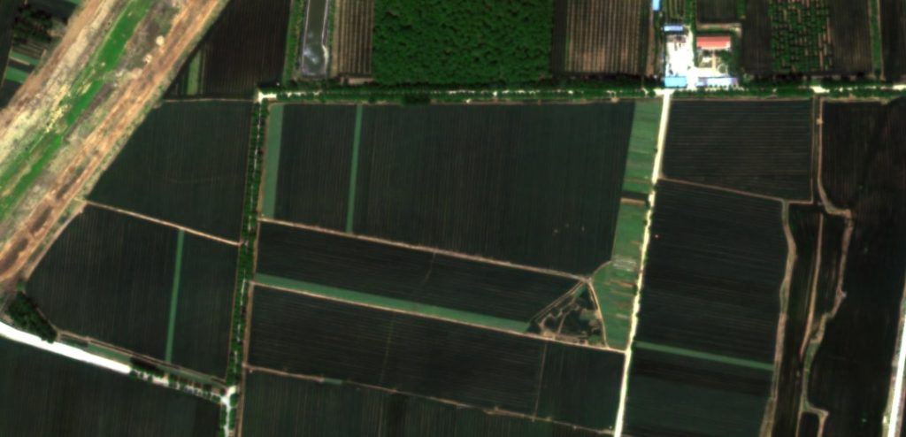
Drone mapping isn't limited to a specific industry; it's incredibly versatile. Aerial mapping drones can be customized with various sensors and cameras to suit specific applications. Whether you need thermal imaging for agriculture, lidar scanning for topographic surveys, or high-resolution cameras for real estate marketing, there's a drone configuration to meet your needs.
What is Drone Mapping Used for?
Drone mapping has diverse applications, including real estate, mining, security, agriculture, and emergency response like fire investigation. Explore how drones are revolutionizing each of these sectors.
Real Estate
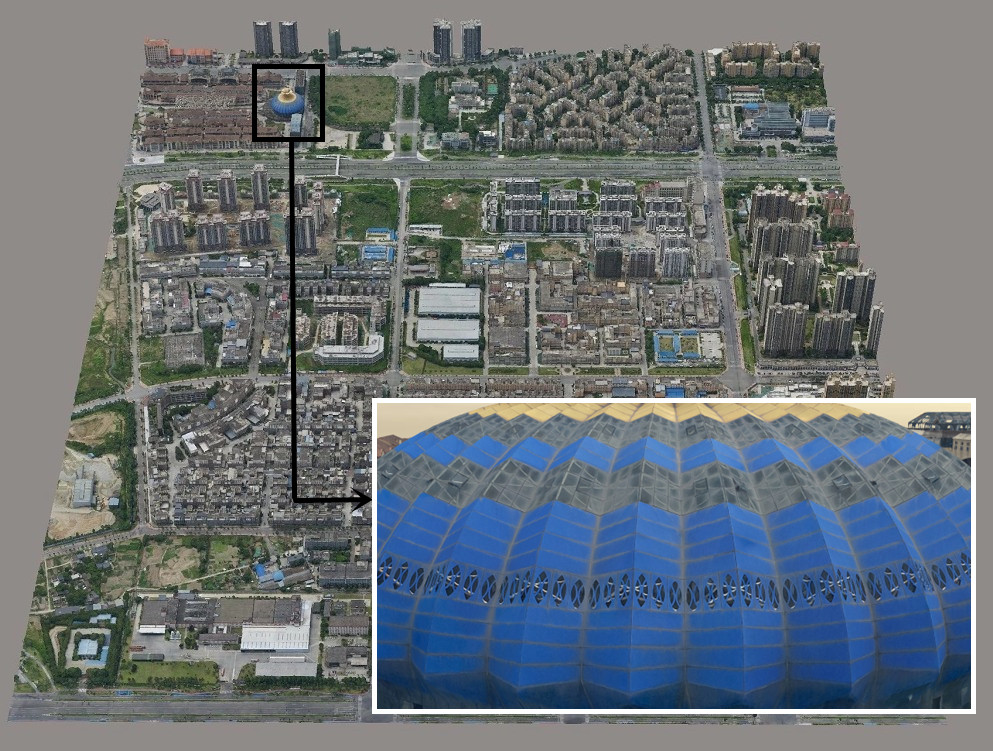
In the realm of real estate, the utilization of mapping drones has become indispensable. Realtors, property developers, and land surveyors have embraced these aerial mapping drones for several reasons. Firstly, drones provide breathtaking aerial views of properties, enhancing the marketing of real estate listings. Potential buyers can now explore properties from the comfort of their screens, thanks to high-resolution cameras mounted on drones.
Additionally, mapping drones aid in land surveying, accurately measuring boundaries, and identifying potential issues such as encroachments. This technology expedites the due diligence process and reduces the risk of disputes.

Mining and Metals
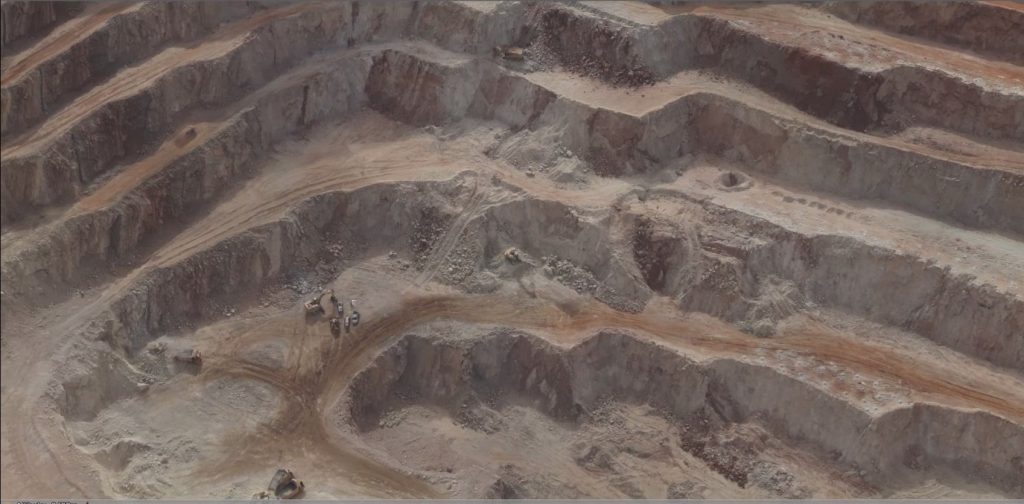
Mining drones have been increasingly used by companies to improve efficiency and safety in their operations. They can survey vast mining sites, providing highly detailed, up-to-date maps and 3D models. This data aids in mine planning, ensuring optimal resource extraction while minimizing environmental impact.
Drones equipped with LiDAR technology can penetrate vegetation and dust, revealing the terrain beneath, even in challenging conditions. The real-time data gathered by these drones helps in monitoring stockpiles, ensuring accurate inventory management.
Security and Surveillance
Security professionals are harnessing the power of mapping drones for comprehensive surveillance and monitoring. Drones equipped with advanced cameras and thermal imaging capabilities can patrol large areas efficiently. In critical infrastructure protection, these drones can detect unauthorized access, potential threats, and perimeter breaches.
They are also valuable in disaster management, providing a bird's-eye view during emergencies and natural disasters. Surveillance Drones empower security teams with real-time data, allowing swift decision-making and response.
Agriculture
The agricultural sector has embraced drone technology to usher in a new era of precision farming. Agricultural drones equipped with multispectral and thermal cameras are used for crop monitoring and management. They can capture valuable data on plant health, pest infestations, and irrigation needs.
With this information, farmers can optimize resource allocation, reduce chemical usage, and ultimately increase crop yields. Drones are particularly beneficial for large farms, where manually inspecting vast fields can be time-consuming and labor-intensive.
Emergency Response
In times of crisis, drone mapping plays a pivotal role in emergency response, particularly in fire investigation. Mapping drones can access areas that are hazardous or difficult for humans to reach. Equipped with thermal cameras, they can quickly identify hotspots and areas of concern during wildfires.
This real-time information guides firefighting efforts, ensuring that resources are deployed effectively. Additionally, drones help investigators reconstruct fire scenes, aiding in post-incident analysis and insurance claims.
What to Consider When Choosing a Drone for Mapping?
Selecting the perfect mapping drone involves considering various factors. We'll guide you through making an informed choice based on:
Types of Drones
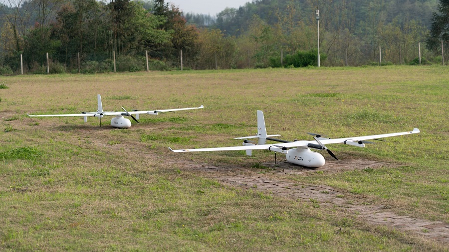
The first decision to make is whether you need a fixed-wing or a multi-rotor drone.
- Fixed-Wing Drones: These are ideal for large-area mapping tasks. They can cover substantial ground and typically have longer flight times compared to multi-rotor drones. If you're mapping extensive agricultural fields or conducting surveys over large construction sites, a fixed-wing drone might be the best choice.
- Multi-Rotor Drones: Multi-rotor drones, like quadcopters and hexacopters, are versatile and can hover in place. They are suitable for more precise and detailed mapping in smaller areas. If you need to capture fine-grained data for real estate mapping or 3D modeling, a multi-rotor drone is a solid option.
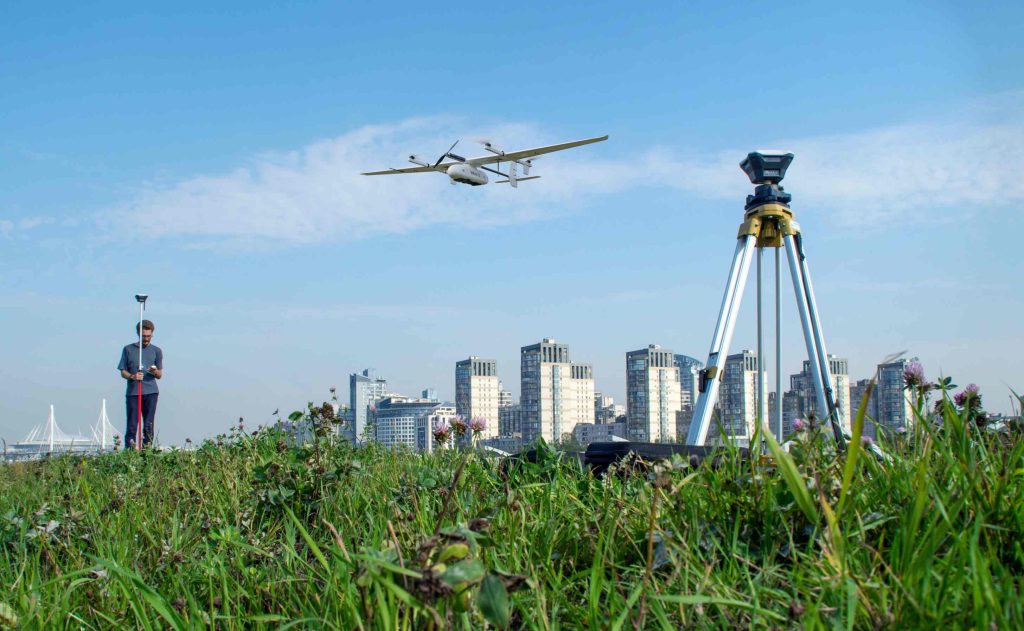
- Hybrid VTOL Drones: Hybrid VTOL drones combine the benefits of both fixed-wing and multi-rotor designs. They can take off and land vertically like a multi-rotor drone but also transition to fixed-wing flight for greater endurance and coverage. Hybrid VTOL drones are excellent for applications where flexibility and efficiency are crucial, such as long-range mapping missions with the ability to cover large areas and land in confined spaces.
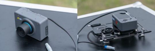
Camera Quality and Payload Capacity
The quality of your mapping data depends heavily on the drone's camera capabilities. Here's what to consider:
- Resolution: Look for drones with high-resolution cameras (e.g., 20MP or more) to capture detailed images. This is essential for producing accurate maps and 3D models.
- Zoom and Thermal Capabilities: Some mapping drones come with zoom and thermal imaging cameras. These are valuable for tasks like wildlife tracking, search and rescue, and thermal mapping.
- Payload Capacity: If you need to attach additional sensors, such as LiDAR or multispectral cameras, ensure that the drone has the necessary payload capacity.
Flight Time and Range
Consider the drone's flight time and control range. Longer flight times are advantageous for covering larger areas without frequent battery swaps, while extended control ranges allow you to operate the drone from a safe distance. Look for options with at least 30 minutes of flight time and a control range of several kilometers for versatility.
RTK and GPS Accuracy
For precision mapping and surveying, drones equipped with Real-Time Kinematic (RTK) and GPS are invaluable. RTK technology provides centimeter-level accuracy, ensuring your mapping data is highly reliable. This feature is particularly important for applications like agriculture and construction, where precision is paramount.
Ease of Use and Autonomy
Consider your level of expertise when choosing a mapping drone. Some models offer autonomous flight modes and obstacle avoidance systems, making them suitable for beginners. Advanced users may prefer drones that allow manual control for greater flexibility.
Software and Data Processing
Mapping drones are only part of the equation. You'll also need robust software for data processing and analysis. Ensure that the drone you choose is compatible with popular mapping and GIS software packages.
Specific Industry Requirements
Tailor your drone selection to the specific needs of your industry:
- Agriculture: Consider drones with multispectral cameras for crop health analysis.
- Construction: Look for construction drones with high-resolution cameras for site surveys and progress tracking.
- Mining: Consider robust drones capable of operating in harsh environments.
- Real Estate: Focus on drones with good camera quality for property photography and 3D modeling.
What Factors Influence Drone Mapping Accuracy?
Achieving accurate drone mapping depends on several factors. Explore how altitude, camera settings, and ground control points influence mapping accuracy and how to optimize them.
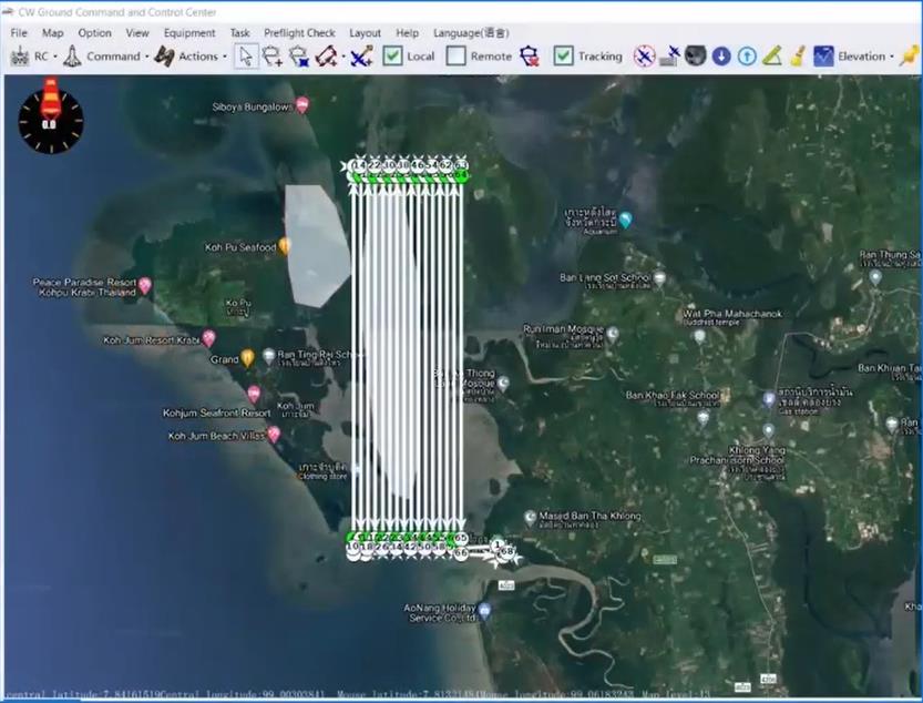
Mission Parameters
When embarking on a drone mapping mission, it's essential to carefully consider several mission parameters to achieve the desired level of centimeter (cm) accuracy:
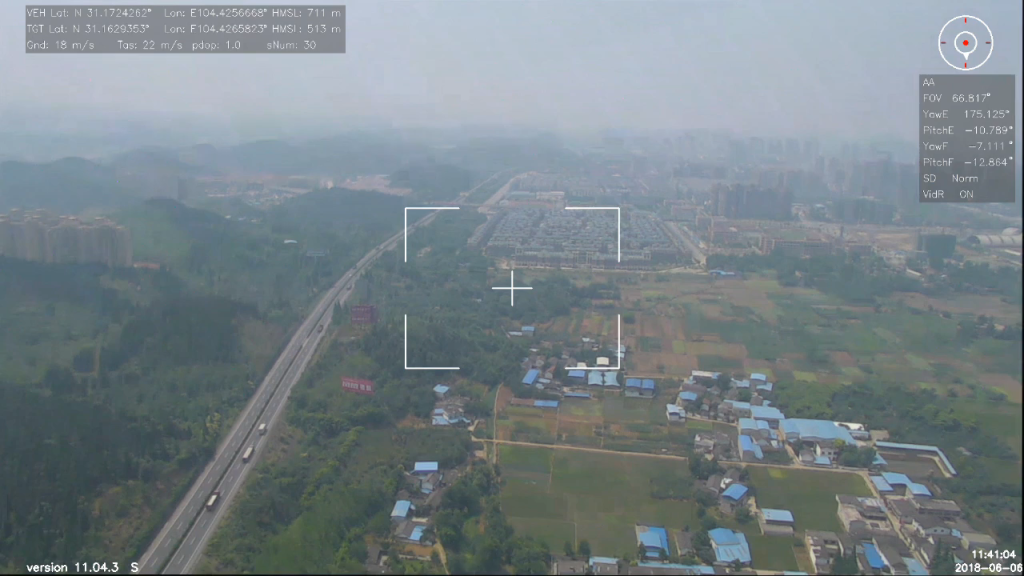
- Image Resolution: The quality of your mapping data starts with the resolution of the images captured by your drone. Higher-resolution imagery results in better data. To attain this, opt for a camera with a high pixel resolution. A minimum of 12 megapixels is required, with 20 megapixels considered ideal for precision mapping.
- Altitude: The altitude at which you fly your drone plays a crucial role in accuracy. Flying higher allows you to cover larger areas quickly but with reduced accuracy. Conversely, flying lower takes more time but significantly improves mapping accuracy. Thus, lower altitudes are preferred for precise mapping tasks.
- Image Overlap: Overlapping of images is another vital parameter. Greater overlap reduces the chances of data gaps caused by camera rotations, tilt, flying height variations, and terrain changes. While more overlap increases flight times, it's a worthwhile trade-off for improved accuracy. Aim for at least 60% side overlap and 75% front overlap, with up to 85% overlap for challenging terrains.
Environmental Conditions
Environmental factors can significantly affect drone mapping accuracy. Here are two critical considerations:
- Weather Conditions: Choose your mapping days wisely. Avoid flying in strong winds, dense cloud formations, or smog whenever possible. While many drones can handle high winds, it's best to steer clear of winds exceeding 7 meters per second (15 mph) for precise mapping.
- Obstacles: In urban environments, tall structures like skyscrapers can obstruct GNSS (Global Navigation Satellite System) signals, leading to multi-path interference and inaccurate data. Be mindful of such "Urban Canyon" scenarios and plan your flights accordingly.
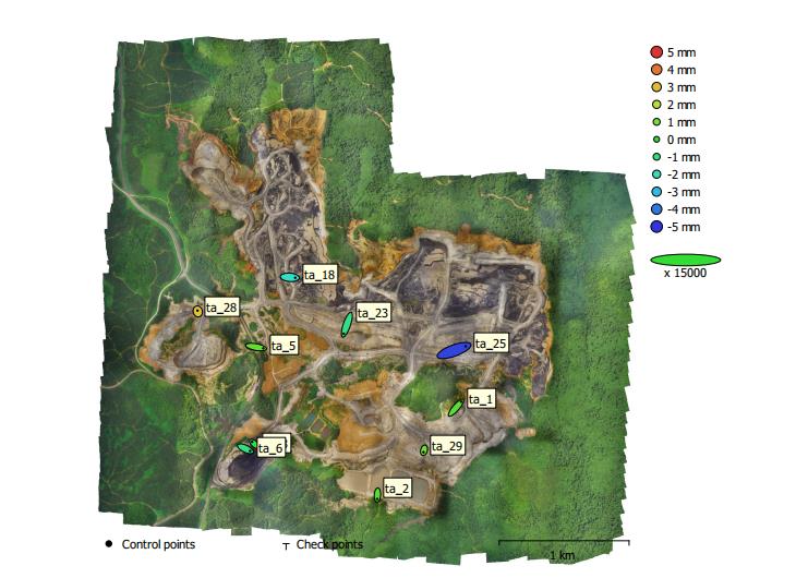
Ground Control Points (GCPs)
Ground control points are indispensable for achieving high mapping accuracy. These reference markers laid out across the mapping area provide known, accurate coordinates on the ground. Here's what you should know:
- Quantity of GCPs: The number of GCPs you use is a subject of study. While more GCPs can significantly enhance mapping accuracy, there's a point of diminishing returns. It's essential to consider the area and terrain. As a general guideline, aim for at least five GCPs on your site.
- Distribution of GCPs: The strategic placement of GCPs matters. Research has shown that evenly distributing GCPs in a triangular mesh grid formation can effectively double their impact on accuracy. Additionally, consider placing GCPs in the corners of the site and at the highest and lowest points for optimal results.
Read More
Let me tell you something that happens way too often.
A company spends $15,000 on a drone, excited about the flight time and range. They get it in the air and mount their LiDAR sensor—and the drone ba

Have you ever watched a drone hover effortlessly over a construction site, inspect a wind turbine blade, or deliver medical supplies to a remote village?
That drone was almost certainly a multirotor.

JOUAV Product News and Use Cases
Fixed-Wing VTOL Drones Insights and Industry Trends
Invitations to online demo events