Benefits and Features
The JOUAV VTOL Hangar is a complete drone-in-a-box solution featuring a weatherproof JOS-C800 docking station, a high-performance CW-15V VTOL drone, and the intelligent Jocloud platform. Designed for 24/7 and all-weather operation, this integrated system automates tasks like drone takeoff, landing, charging, and data transmission and processing.
product-detail
30-50km Operation Radius
Cover large areas with a single deployment
product-detail
180min Flight Time
Handle extended missions without recharging
product-detail
IP54 Rated
Built to withstand dust, dirt, and light rain showers
product-detail
Private Deployment
Open SDK enables developers to create integrated applications
product-detail
Complete Situational Awareness
Multi-layered monitoring with cameras & weather sensors
product-detail
Seamless Cloud Management
Manage missions, data, and fleets from anywhere
product-detail
Third-Party Payload Support
Open system integrates seamlessly with various payloads
product-detail
-20℃ to 50℃ Operating System
Operate with confidence in extreme temperatures
JOS-C800 Station: Rock-Solid, Ready 24/7
The JOS-C800, the heart of the JOUAV VTOL Hangar, is a weatherproof drone station that charges, stores, and safely lands your CW-15V drone – all autonomously.

120min Fast Charge

With a powerful 20A charging current, the JOS-C800 rapidly charges drones upon their return from missions. It efficiently reaches 80% charge in just 70 minutes and achieves a full 100% charge within 2 hours, minimizing downtime and optimizing operational efficiency.

img
img

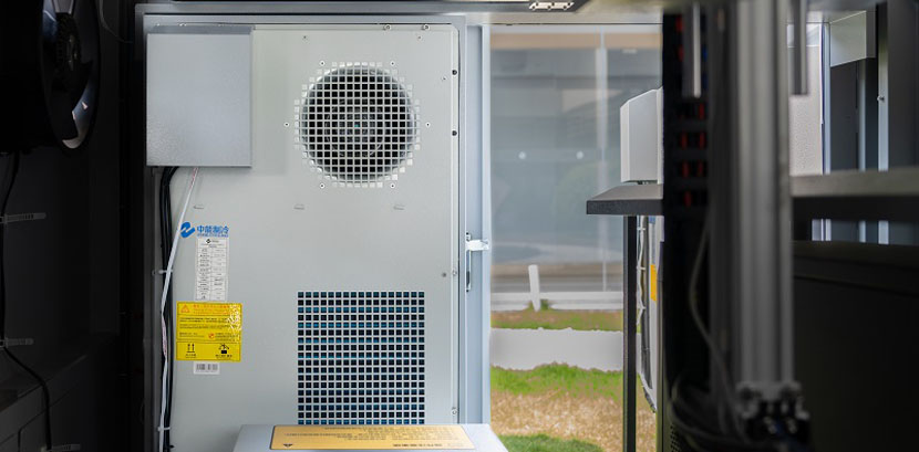
Multi-Layered Protection

The docking station features a dual control system with automatic temperature-sensitive fire extinguisher deployment and remote-controlled fire extinguishing agent release for enhanced safety. Real-time surveillance cameras inside and outside provide continuous monitoring, while overload protection and leakage prevention safeguard against electrical risks.

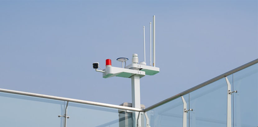
Built-in Base Station

A built-in base station with data link antennas facilitates reliable UAV communication. Integrated high-definition cameras, a weather station, GPS, and RF infrastructure enable comprehensive mission management and real-time environmental monitoring.

img
img

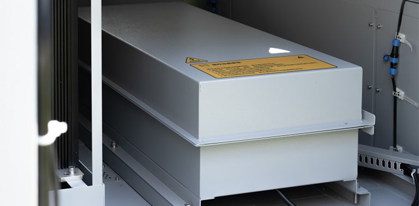
4 Hours Power Backup

In the event of power outages, the built-in UPS (Uninterruptible Power Supply) system ensures uninterrupted operation for over 4 hours. This feature provides ample time for drones to return to the station, even during unexpected disruptions safely.

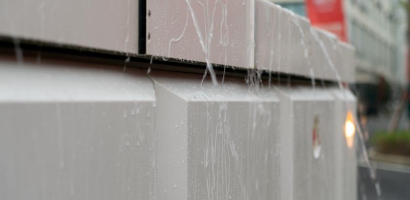
24/7 Operation in Any Condition

Built to withstand harsh conditions, the charging station boasts IP54 dustproof and waterproof certification. It operates reliably in temperatures ranging from -20℃ to 50℃ and altitudes up to 4500 meters, making it suitable for diverse environmental challenges.

img
CW-15V VTOL Drone: Fly Further, See More
The CW-15V features exceptional range, precision positioning, and advanced obstacle avoidance for reliable operations in various conditions.
180 min
Flight Time with Payloads
50 km
Long Range
4kg
Payload Capacity
3cm
Vertical Positioning Accuracy
13.8 m/s
Wind Resistance
IP43
Ingress Protection

Advanced Obstacle Avoidance

The CW-15V prioritizes safety with a dual obstacle avoidance system. A downward millimeter wave (MMW) radar detects objects in its path, while a visual obstacle avoidance system provides additional real-time situational awareness, ensuring safe and reliable flight operations.

Automatic Return, Safe Take-off & Landing

Whether experiencing signal loss or critical battery levels, the drone automatically returns home. For added security, it plans take-off and landing paths based on wind direction and can re-select a safe landing zone if obstacles arise, ensuring smooth and worry-free operation.

Dual Payloads, Double Efficiency, Zero Swap
Fly further, faster with the CW-15V's dual payload bays. Equip two sensors at once - our standard combo includes monitoring & mapping - for comprehensive data collection in a single flight. Eliminate swap time, streamline workflow, and maximize productivity.
grid-image

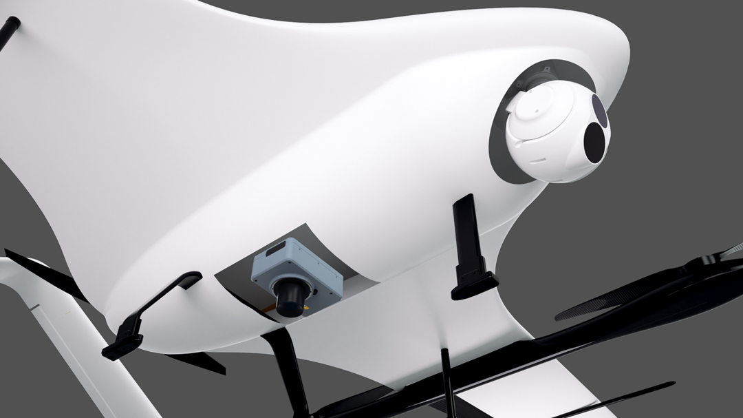
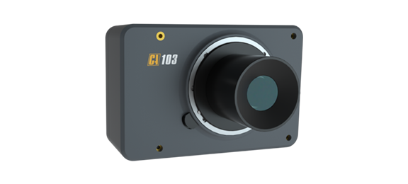
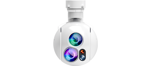
Gimbal Camera + RGB Camera

Dual-light Gimbal Camera

  • Visible Light Camera:
    • 1920x1080 resolution
    • 30x optical zoom
    • a focal length of 4.3-129mm
  • Infrared Thermal Camera:
    • 640x512 video resolution
    • a 35mm focal length
    • 2x digital zoom

RGB Camera

  • Full-frame Exmor R CMOS sensor (35.7x23.8mm)
  • 35mm focal length
  • 61MP effective pixels
grid-image

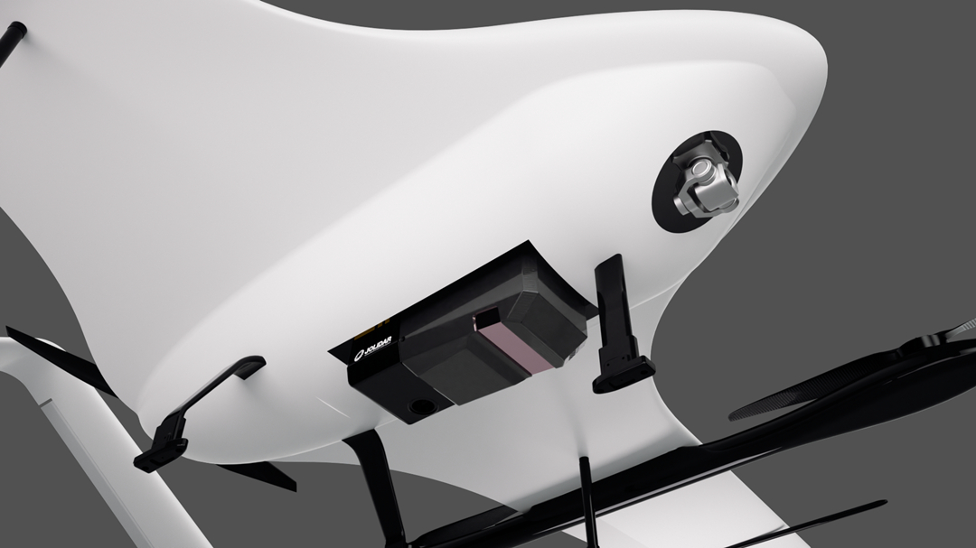
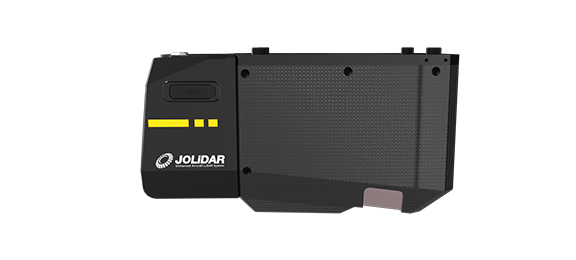
Gimbal Camera + LiDAR Sensor

Single-light Gimbal Camera

  • 6x digital zoom
  • 21mm focal length
  • Sony 1/1.7" sensor
  • 8MP effective pixels
  • 4K resolution (4096x2160) @25fps

LiDAR Sensor

  • 100° field of view
  • Up to 1500 kHz laser pulse frequency
  • 300 lines/second scan rate
  • 5cm accuracy at 300m distance
  • Up to 25km² coverage in a single flight (50% overlap, 200m altitude)
  • 7 Returns, suitable for dense vegetation
  • Object detection up to 1000m away with 80% reflectivity
  • 26MP half-frame camera (6252x4168 resolution)
Optional Payloads
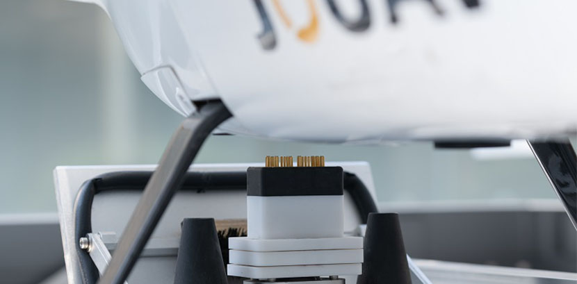
The JOUAV drone-in-a-box solution offers a versatile platform for diverse applications.  To further enhance its functionality, you can equip your CW-15V drone with a variety of optional payloads.
CA-103 Aerial Camera
61 MP full-frame camera for land surveying, urban planning
MG-120E EO/IR Gimbal Camera
Lightweight 3-axis gimbal camera with 30X optical zoom and thermal sensors
JoLiDAR-1000
An Affordable, Mid-Range LiDAR System with High Precision
Jocloud: AI Command Center in the Cloud
Jocloud empowers you to seamlessly control your JOUAV VTOL Hangar missions. Plan & manage flights, access real-time data anywhere, and leverage AI for insights - all in one platform.
Effortless Mission Planning

Craft intricate flight paths with ease, whether you need linear surveys, detailed area coverage, or high-resolution orthographic maps. Define waypoints, set specific areas of interest, and schedule tasks with precision. Jocloud also allows you to orchestrate synchronized missions for multiple drones, maximizing efficiency.

Real-Time Data Visualization

Monitor live video feeds, view high-resolution orthomosaics for detailed inspections, and analyze LiDAR point clouds for 3D terrain mapping – all from a single platform. Jocloud grants you secure access to this critical data from anywhere, be it your command center, a field vehicle, or even a mobile device.

AI-Powered Insights

Jocloud utilizes advanced AI to prioritize potential anomalies within the live video stream, highlighting areas of concern and enabling rapid decision-making. Additionally, video marking and augmented reality overlays let you annotate critical information directly onto the live feed, facilitating clear communication and collaboration with your team.

Streamlined Data Management

Jocloud automates the heavy lifting of data management. It automatically processes all collected data, meticulously records flight details, and compiles comprehensive reports. These reports are enriched with AI-generated insights, providing a clear picture of your mission's success and potential areas for further exploration.

Open Ecosystem, Endless Possibilities
The JOUAV VTOL Hangar isn't just a powerful autonomous drone solution; it's a platform designed for innovation. Our open ecosystem empowers you to tailor the system to your specific needs.
item-icon
Integrate Any Payload
The CW-15V drone boasts an open architecture with a common API, empowering developers to design custom payload applications. Its dual payload bays, located on the nose and belly, can house two third-party sensors or equipment simultaneously for versatile mission execution.
item-icon
Integrate Drone Data with Any Cloud
Jocloud supports various video transmission standards (RTSP, RTMP, GB28181, UDP). This allows you to integrate data and video feeds into your preferred third-party cloud platform for maximum flexibility in data management.
item-icon
Customize Flight Operations
Designed for flexibility, the JOS-C800 supports open SDK integration, allowing seamless adaptation to third-party systems. This capability enables customization of flight control functions, catering to specific operational needs across various industries.
item-icon
Connect Any Drone Platform
Jocloud supports industry-standard API and MQTT protocols. This enables seamless integration of third-party drone platforms, ensuring compatibility with your preferred systems.
Industry Applications
This  is a revolutionary solution for a wide range of industries. Its automated operation, long-range capabilities, and diverse payload options make it ideal for:
Water Resources
"Smart water resources" needs to rely on modern technical means to establish a basic water resources information perception system, improve the support system, promote the fine management of integrated water resources.
Smart City
Digital Earth and Smart Earth put forward the slogan for efficient application of resources and environment. The construction of smart cities require drone remote sensing technology to obtain surface data in a short period of time.
Power Line Inspection
Drones are an attractive alternative for power line inspection. but what are the benefits, outputs, and applications? Let's explore more.
Technical Specifications
JOS-C800 STATION
Size (W×LxH)
2.45 x 1.9 x 1.9m [8 x 6.2 x 6.2ft](Folded)
Operating altitude
4500m[14763.8ft]
Operating temperature
—20℃—50℃
Power supply
AC 220V 50Hz
Drone battery recharge method
Automatic charging
Drone charging time
81% in 70min, 100% in 120min
Maintenance interval
Half yearly
Protection level
IP54
Other functions
Air pressure, temperature, humidity, wind speed/direction, rainfall, and real-time images; Automatic fire suppression; External environmental monitoring; Real-time dual-light surveillance video transmission
Communication
1000M network, optical fiber
Weight
850kg (with 4 hours UPS power)
CW-15V VTOL DRONE
Fuselage Length
1.72m[5.64ft]
Wingspan
2.22m[ 7.28ft]
Max. flight time
180min, single-light gimbal & RGB camera
150min, dual-light gimbal
Max. cruising speed
72km/h[38.9kts]
Max. take-off altitude
4500m[14763.8ft]
Precise landing
RTK+ Visual Guidance
Operation radius
30km ~ 50km [ 18.6 ~ 31.1mi ]
* All performance data in the foregoing pages are theoretical values obtained by JOUAV® internal laboratories through tests carried out under particular conditions. For more information on the specific testing conditions, refer to the aforementioned product details. Actual performance may vary owing to differences in individual product configuration, software versions, application conditions, and environmental factors. All data is subject to actual usage.