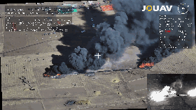
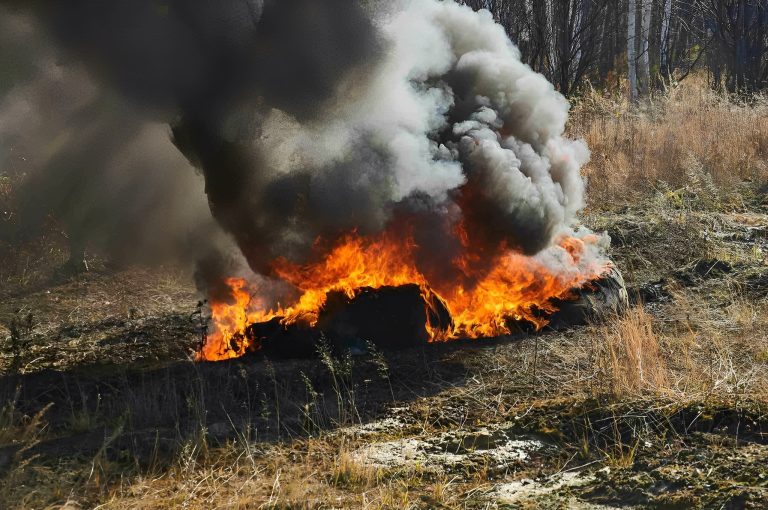
During the deep Qinghai autumn, telltale plumes of smoke rise from the grassland in the east.
Qinghai is a landlocked province in northwest China. Its eastern region is highland pastoral areas i
Benefits of drones in emergency services
Emergency services across the country could benefit from using drone technology in a variety of ways:
- Rapid deployment: Unlike helicopters, UAVs do not require runways or landing fields that can be launched quickly and easily from almost anywhere.
- Access to remote areas: Emergency response drones can access remote and difficult-to-reach areas, enabling first responders to reach people and places that would be inaccessible by other means.
- Improved situational awareness: With a bird’s eye view of the situation, drones provide first responders with a better understanding of the environment and help them make decisions faster.
- Faster response time: Drones can quickly cover large geographic areas and provide real-time data to first responders, enabling them to make informed decisions and respond more effectively.
- Increased safety: Drones minimize the risk to emergency responders by allowing remote operation from almost anywhere. In search and rescue, thermal sensor-equipped drones efficiently detect people in hard-to-reach areas like rubble and tunnels.
- Cost savings: Drones help disaster response by quickly assessing damage, enabling accurate damage assessment, reducing costs, and speeding recovery. In addition, they reduce transportation costs by delivering medical supplies to remote areas.
How drones are used in emergency management?
First responder drones are now being used in a variety of ways to help people in emergencies. From providing critical information to delivering vital supplies, drones are proving to be an essential tool in emergency situations.
Monitoring hazardous areas
Emergency drones can actually help prevent accidents and injuries. They are often used to monitor hazardous areas, such as construction sites or industrial sites, to detect potential safety risks and alert workers to take action. Drones can also be used to monitor and inspect infrastructure, such as bridges or pipelines, to detect any potential issues before they become a safety hazard.
Providing real-time situational awareness
Drones can provide critical information in emergency situations. With applications to quickly survey a disaster site, drones can provide valuable insight into the local situation. Such information can help first responders make decisions about the best way to respond to the situation. Beyond that, drones are useful for identifying areas of concern, such as collapsed buildings, hazardous materials, or blocked roads. This data can then be used to help direct resources to the most severely affected areas.
Search and rescue
Search and rescue operations are often dangerous and can involve access to hazardous environments that are difficult for humans to access. And rescue drone technology allows search teams to quickly and efficiently cover large areas and locate missing persons.
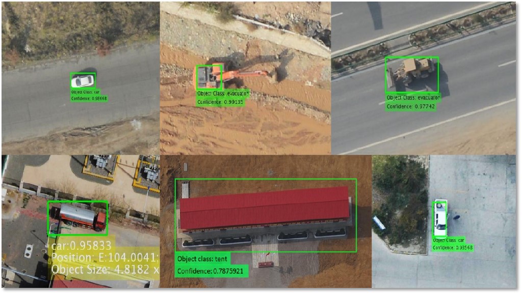
Equipped with a variety of sensors, such as thermal imaging cameras, rescue drones enable search teams to quickly detect heat signatures, as well as high-resolution cameras and audio pickups, which can provide valuable information about terrain and environmental conditions.
Delivering medical supplies
Emergency response drones can also be used to deliver vital supplies in emergency situations. Drones can quickly and safely transport medical supplies, food, and other essentials to areas that would otherwise be difficult to reach. This can be especially helpful in areas that are affected by natural disasters, such as floods or earthquakes. Drones can also be used to deliver medical equipment, such as defibrillators, to areas that may not have easy access to medical services.
Insurance assessment
Drones can survey damaged buildings, roads, bridges, and other structures, providing a comprehensive overview of the affected area. Images taken by drones can be used to calculate the cost of repairing or replacing damaged property so that insurance companies can quickly assess claims and provide compensation to policyholders.
Post-disaster reconstruction and recovery
Drones enable the possibility of quickly surveying and collecting data after a natural disaster. The 3D models and orthophoto maps collected by drones can be used to identify areas that have been damaged, assess the extent of the damage, and plan the reconstruction process. They can also be used to inspect critical infrastructure, such as bridges and power lines, to assess the extent of the damage and determine if they are safe for use.
What types of drones are used for emergency services?
Drones for emergency response services come in all shapes and sizes and can be used for a variety of purposes. Here are some of the most common types of drones:
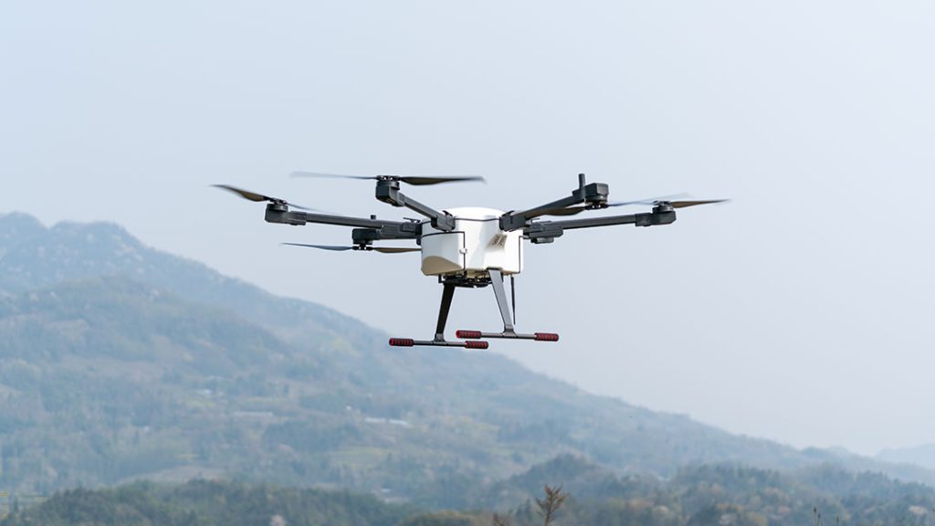
Multi-rotor drones are the most popular choice in emergency services. They are easy to maneuver and have the ability to hover in place, making them ideal for capturing images or video from a variety of angles. However, they are not the most effective option for long-range surveillance because their battery life is limited by the amount of time they can stay in the air.
Fixed-wing drones are better suited for long-range surveillance because they can cover more ground in a shorter period of time. They are also more aerodynamic, which increases their range and efficiency. However, they are not as maneuverable as multi-rotor drones and require a runway or launch pad to take off.
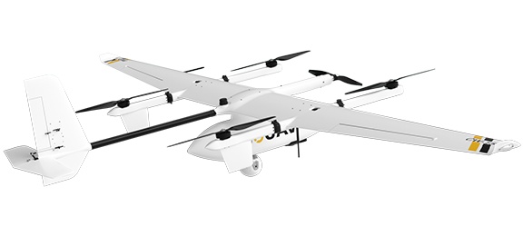
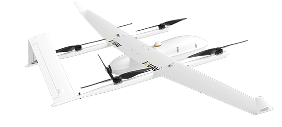
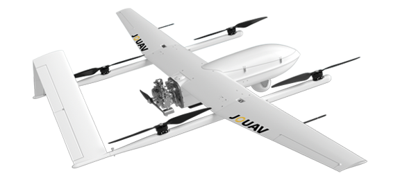
VTOL (vertical takeoff and landing) drones are a relatively new technology with the benefits of both multi-rotor and fixed-wing UAVs. They have the ability to take off and land vertically like multi-rotor drones, while also flying long distances like fixed-wing drones. This makes them ideal for disaster response and relief operations and for monitoring hazardous situations, as they can cover large distances quickly and also hover in place for detailed observation.
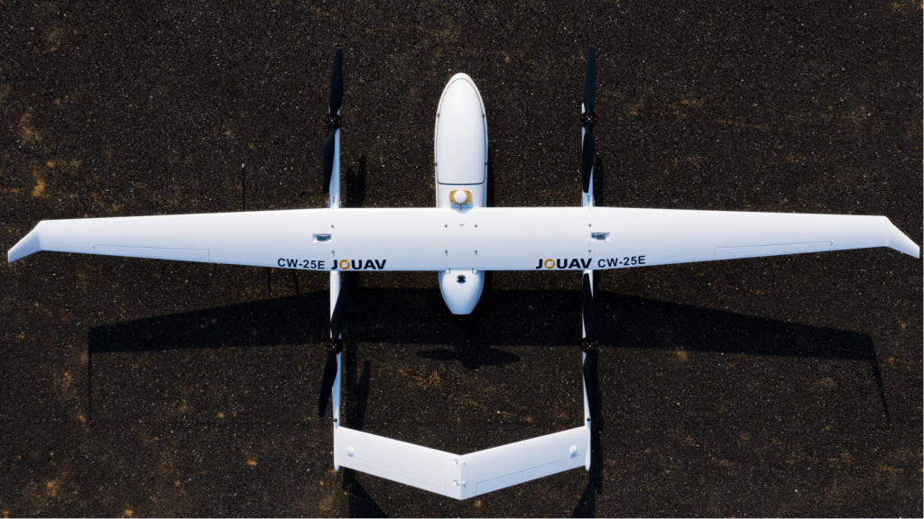
Up to 480 min of flight time and 200km of range
In addition to its VTOL capabilities, the CW Series UAVs also offer a large coverage area and long range. With a flight time of up to 480 min and a range of over 200 km, JOUAV drones can survey vast areas in a single mission, providing emergency response teams with a comprehensive view of the situation on the ground. This helps teams make more informed decisions and respond more effectively to emergencies.
- Check this blog post for a detailed review of the best long-range drones
Interchangeable HD camera
JOUAV emergency drones can be equipped with payloads of different weights, ranging from 0.8-25 kg, allowing them to adapt to different situations and meet the needs of different rescue and response teams. Whether you want to use thermal sensors to detect heat signatures from a distance, multi-spectral and hyperspectral cameras to capture high-resolution images for damage assessment or powerful speakers to alert ground personnel and civilians, the JOUAV drone can quickly and easily swap out these payloads to meet your the specific needs.
AI tracking and live streaming
Equipped with an EO/IR gimbal camera, JOUAV drones can identify and track objects in the camera's field of view, such as people, vehicles, or wildlife. This information can then be transmitted in real-time to a central command center or to authorized personnel, who can monitor the live feed and take appropriate action if necessary.
Fast deployment and autonomous flight
JOUAV autonomous drones come with a GPS-based autopilot system that can fly the drone autonomously. This not only increases efficiency but also reduces the risk to response teams who often work in hazardous environments. Their flight control software is very simple to operate which makes it accessible to those with limited technical knowledge. With just a few taps on the control application, the self-driving drone can be deployed quickly, providing critical information in minutes.
Active safety flight technology
JOUAV drone is equipped with several safety features that ensure a safe and secure flight. It features obstacle avoidance sensors that detect and avoid any obstacles in the drone's path, ensuring a safe flight. Moreover, the JOUAV drone also has a return-to-home function that automatically brings the drone back to its starting point in case of a low battery or signal loss.
Excellent environmental adaptability
The JOUAV emergency drones are designed to be highly adaptable to the environment it is in. It has a rugged design that enables it to handle harsh weather and temperatures of -20°C to 50°C. In addition, it is waterproof and dustproof for use in challenging conditions, such as rain, wind, and dust.
Recommended UAV platforms
Best emergency management software
In addition to UAV platforms, JOUAV also provides the best emergency management software, JoCloud. As a cloud-based platform, the JoCloud typically integrates multiple data sources, including UAV sensors, ground-based systems, and remote sensing technologies, to provide real-time information about the emergency situation. This information is then analyzed and processed to create actionable insights that can be used to inform response efforts.
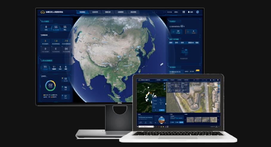
With the JoCloud, data can be stored and processed at scale, allowing for real-time analysis and decision-making. Meanwhile, multiple stakeholders, including emergency responders, government agencies, and NGOs, can access the same data and work together to respond to the emergency effectively.
Real-word cases of JOUAV drone solutions
Explore some real-world cases where JOUAV drones have been used to save lives and support emergency responders in challenging situations. From earthquake response to firefighting operations, these cases demonstrate the potential of drone technology to make a real difference in times of crisis.
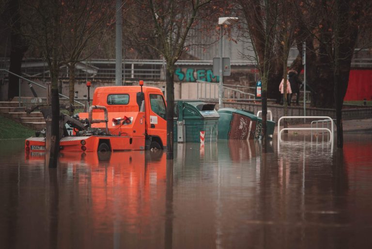
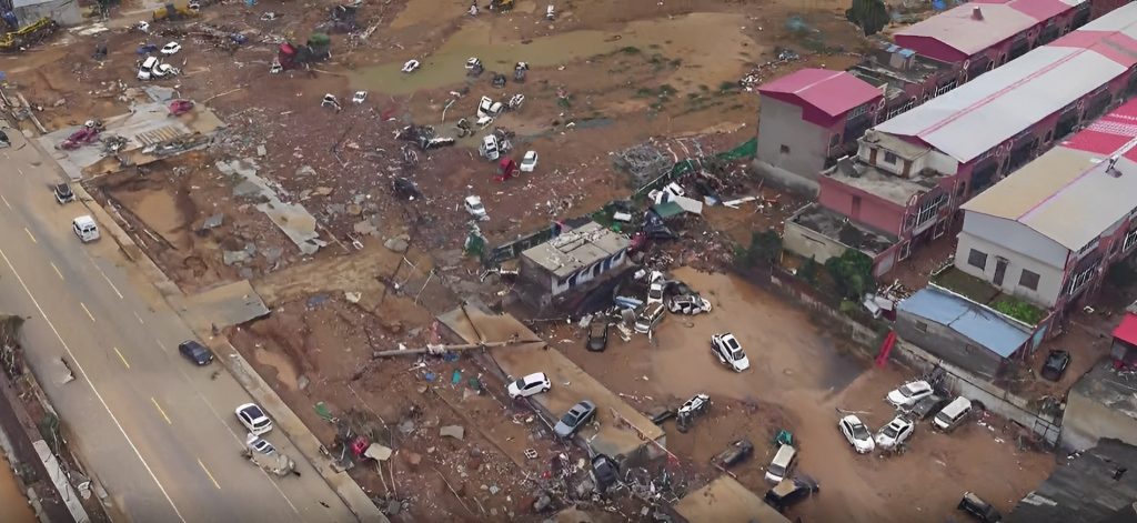
Home to an estimated population of 99.41 million residents, Zhengzhou is the capital and largest city of Henan, China. Between 17 and 31 July 2021, Zhengzhou experienced catastrophic flooding as a res
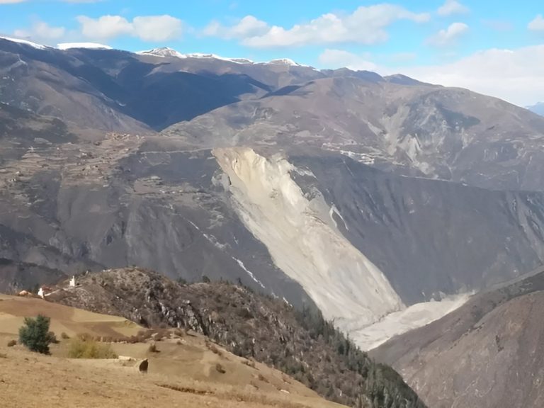
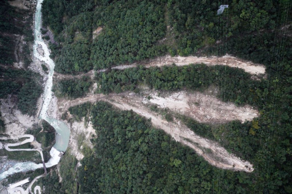
The Jinsha River, as the upper reaches of the Yangtze River, flows through four provinces including Qinghai, Tibet, Sichuan, and Yunnan in western China. On Oct. 11, 2018, a large-scale landslide occu