At 2:27 PM on a storm-lashed afternoon in July 2025, a small fishing boat capsized off the coast of Gulei, Zhangzhou.
Two men were thrown into violent waters. Winds howled at gale force. Waves surged
Home to an estimated population of 99.41 million residents, Zhengzhou is the capital and largest city of Henan, China. Between 17 and 31 July 2021, Zhengzhou experienced catastrophic flooding as a result of historic intense rainfall.
The observed precipitation surpassed the historical record of past decades and caused 73 fatalities and 15,500 collapsed structures.
Traditional aircraft remote sensing has limitations
In the case of a flood, emergency responders must know the path of the flooding that is occurring. Once the floodwaters have receded, the challenge is to assess the extent of the damage.
Traditional methods rely on the use of satellite data or aerial imagery collected from aircraft. But these methods can be affected by low cloud cover and aircraft can be expensive to deploy.
Therefore, it was decided that drones would be used. Drones are usually cheaper and easier to operate. Unlike conventional aircraft, drone flights can be conducted by trained volunteers without the need for a licensed pilot.
Emergency services call for drone support
As the situation worsened, National Emergency Management Center called in support from JOUAV and their specialist drone team. In the afternoon of July 21, the team members listened to the unified deployment of the command department and flew the JOUAV CW-15 UAV with CA502R to make instant sensing of the designated disaster area and feed valuable information to the emergency responders.
"It's hard to imagine how we would have to drone this without this aerial perspective," commented Captain John Song of the Zhengzhou rescue team." It has been instrumental in providing truly high-quality intelligence that we could not have seen in any other way."
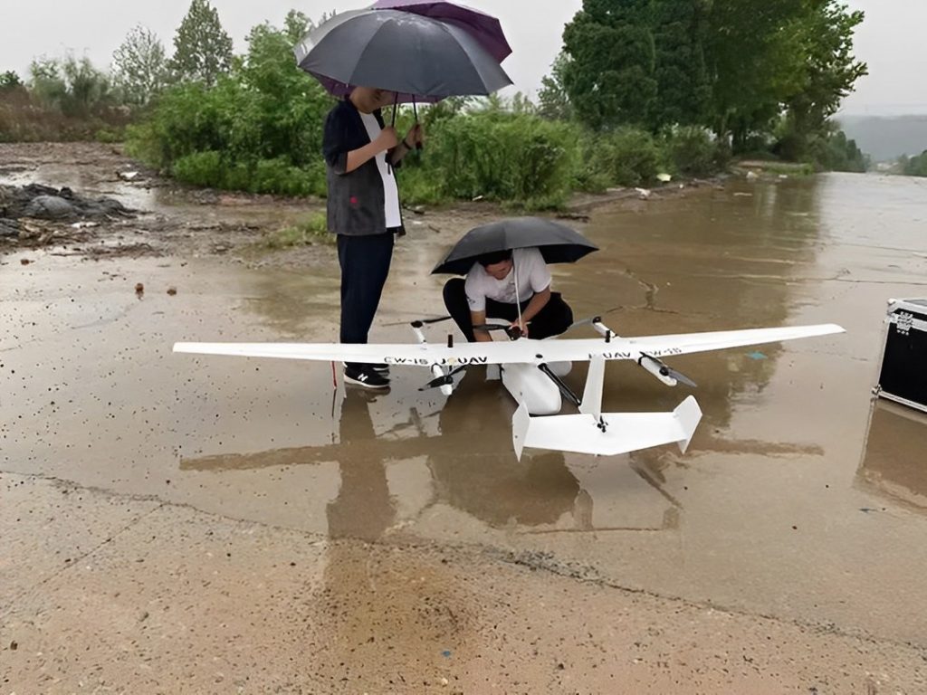
Two crew members doing pre-takeoff checks.
Challenge of accurate 3D flood modeling
City officials wanted the corridor map to cover 5km2 in less than 5 hours and with the high accuracy required. Using the CW-15 vertical takeoff and landing fixed-wing drone allowed for longer stays in the air and rapid coverage of a large area, but there is a challenge.
The team had to pay close attention to flight safety, as the drones flew in heavy rain and strong winds. In rainy weather, visibility can be severely reduced due to fogging, which means the likelihood of getting caught in a drone crash becomes greater. A strong gust of wind can disrupt the flow of air that drones rely on to lift off.
Performing well in heavy rain and strong wind
It's worth emphasizing here that the CW-15 VTOL drone is built to handle severe weather conditions. With Water-proof and wind-resistant capabilities, it can safely fly and capture data in sustained winds up to 10.8m/s (4.8 mph) and gusts up to 13.8m/s (6.2mph). The drone is also able to resist brisk rain for an extended period.
"That's the great thing about JOUAV: we can safely cover large disaster areas. We don't have to take the risk that it will go off course. The hard part for any drone is the landing. During this mission, it rained all the time in Zhengzhou accompanied by a very strong wind, but we managed to land very well." Luis Liu is one of the pilots of the Zhengzhou rescue team.
Mapping a 5km2 to 3.5cm GSD in 2 hours
The rescue team deployed the CW-15 with a CA502R oblique camera to complete aerial mapping of a 5km2 area 3 hours ahead of schedule. The rescue team estimate that it would take 1 to 2 days to hire a manned aircraft to conduct the same survey. It would have cost $1,500 per hour, plus the risk to the crew in the wind.
The drone surveying not only saved the team and the government a lot of time but also collected highly accurate data.
"We collect data at the centimeter level, and our results are 3.5 cm (1.4 in.) GSD. digital elevation models must be very accurate so that we can accurately assess the extent of damage to help communities start to recover." John Song said.
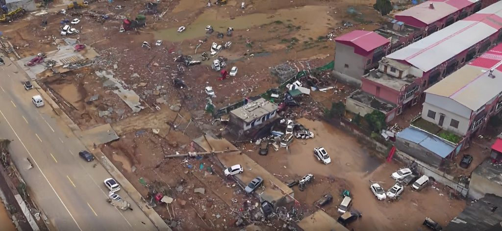
The oblique imagery of the Henan flood was captured by CW-15.
The road ahead…
When a disaster strikes, a rapid and effective emergency response is critical to assisting the population, reducing the number of victims, and mitigating the economic impact. During emergencies, accurate data collection can be difficult due to a lack of coordinated action among agencies during a disaster.
Drones not only provide fast, actionable data, but also augment and protect first responders on the scene with aerial insight. It is a true force multiplier, cost-effective, allows for sensor and payload flexibility, and is a rapidly deployable asset.
More Use Cases


Chongqing’s Qinba Mountains are basically a giant green wall protecting the region. But there’s a problem – pine wood nematodes are eating through it. Fast.
The forestry department n

When TotalEnergies set out to build one of Southeast Asia’s largest solar and battery storage projects—spanning 12,000 hectares across the dense acacia forests of Riau, Indonesia—they faced a problem

JOUAV Product News and Use Cases
Fixed-Wing VTOL Drones Insights and Industry Trends
Invitations to online demo events