At 2:27 PM on a storm-lashed afternoon in July 2025, a small fishing boat capsized off the coast of Gulei, Zhangzhou.
Two men were thrown into violent waters. Winds howled at gale force. Waves surged
Imagine inspecting critical power lines deep in mountainous terrain—all without leaving your desk. At Yunnan Power Grid in China, this is now a daily reality.
With a simple click of the “Take Off” button from an office in Kunming, a drone located 140 kilometers away autonomously launches from its hangar, navigates high-altitude landscapes, and performs a detailed inspection mission—all without human intervention on-site.
Challenges of Yunnan’s Terrain
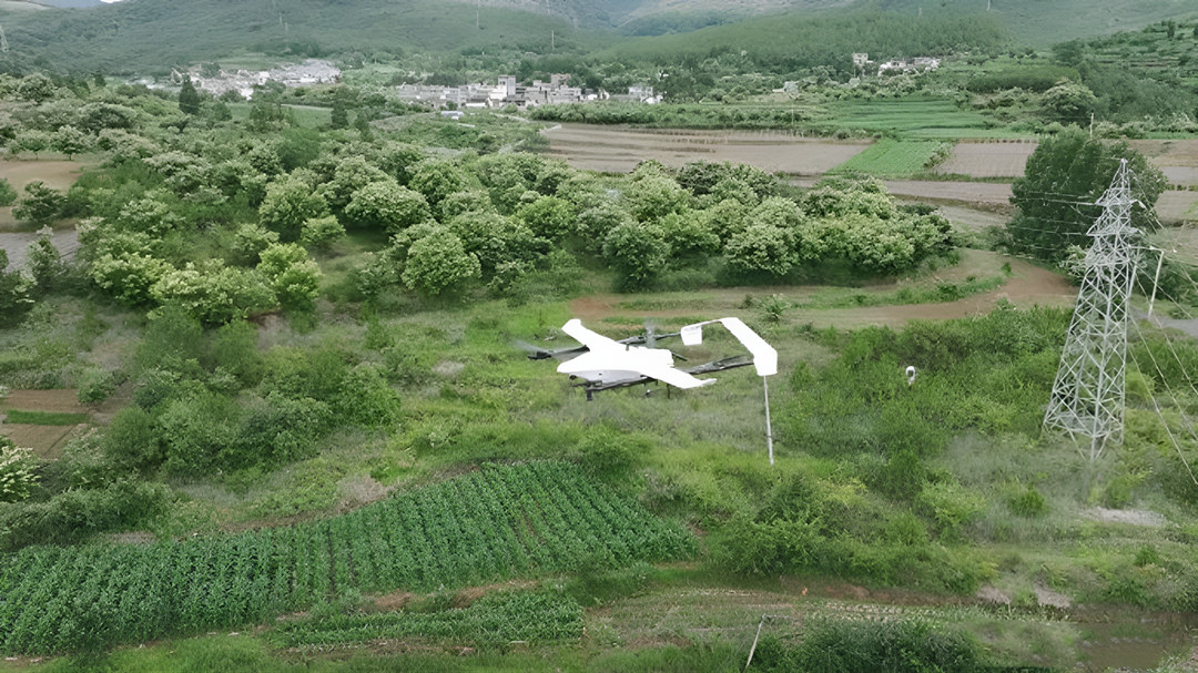
Yunnan lies on the rugged Yunnan-Guizhou plateau, where 80% of power lines traverse steep mountains and valleys. Altitudes range from a few hundred meters up to over 6,000 m, and many transmission routes sit 2,000–4,000 m high.
Manual patrols in these conditions can take hours of climbing per tower and involve high safety risks. In fact, traditional “foot patrol” methods once required ~20 days to inspect 100 km of line, whereas drones can do the same in only 4 days.
Dense karst landscapes and thick vegetation further hide faults from view. By contrast, autonomous drones allow one-click aerial surveys: the aircraft automatically follows pre-programmed flight paths, avoids obstacles, and collects high-resolution imagery and LiDAR data. This dramatically reduces risk and manpower while catching defects that ground teams might miss.
Strategic Hangar Deployment and Mission Execution
To meet these challenges, Yunnan Power Grid Co., Ltd. has installed JOUAV’s VTOL Hangar (JOS-C700 station + CW-15V drone + Jocloud) at a substation in Luquan County. The hangar is a fully automated, weatherproof docking station that houses and recharges the drone, enabling 24/7 operation in any condition.
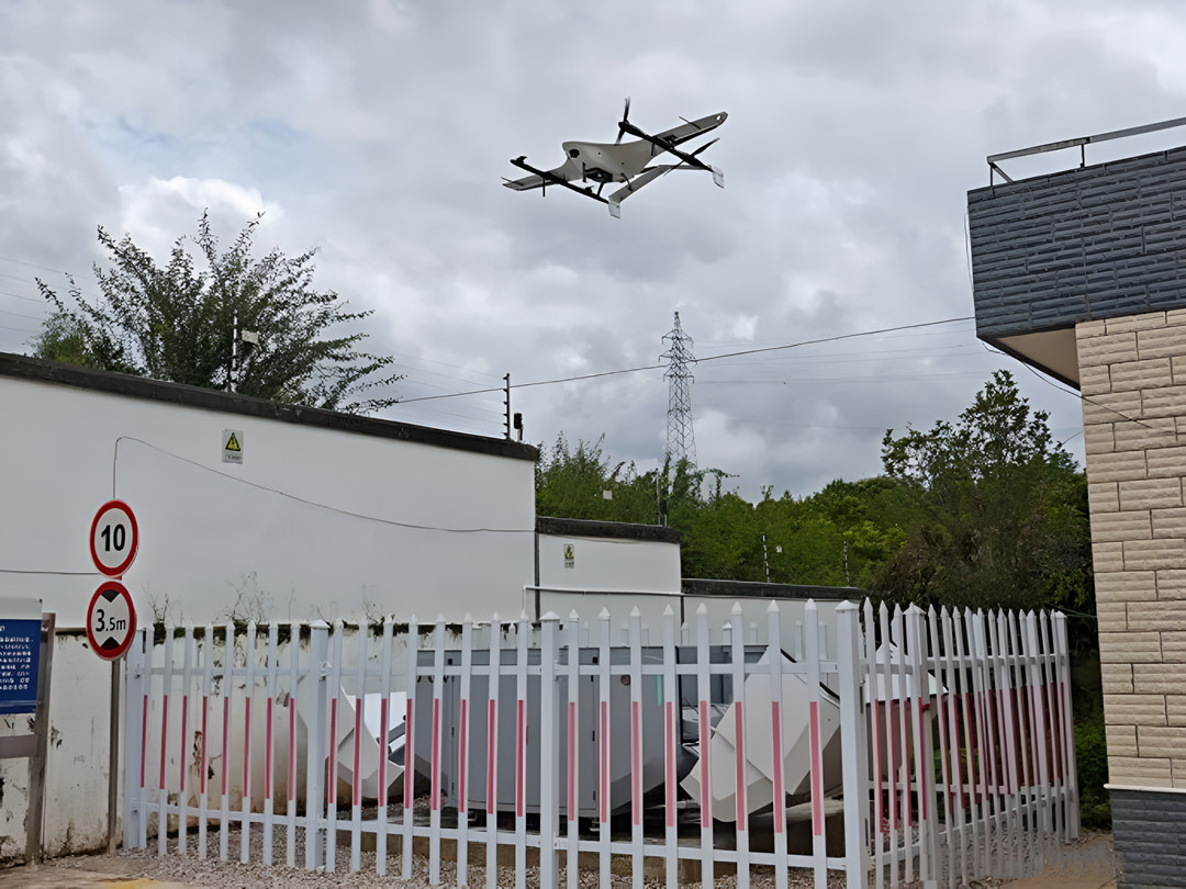
Once the operator presses “takeoff,” the CW-15V drone autonomously launches and follows its route. In the demonstrated mission, the drone flew a 19.4 km section of the 220 kV “Saizhong” line, performing continuous 3D LiDAR scanning and transmitting data live to the control room.
Key results from this deployment include:
- 80% time savings and 5× efficiency boost: Manual control time dropped by nearly four-fifths, while coverage per mission soared almost five-fold.
- Huge coverage area: One hangar now covers ~251.2 km² of terrain—about 35 times the area of a typical multi-rotor UAV system.
- Long single-flight range: A CW-15V can survey >80 km of line in one sortie, far beyond what a multi-rotor can achieve.
- “Remote-seat” operation: Inspectors can oversee 15 major transmission corridors (including “West-East Power” lines and UHV projects) from the office, without physically climbing any towers.
System Components and Technical Highlights
The JOUAV VTOL Hangar powerline solution combines three elements: the JOS-C700 automated station, the CW-15V VTOL UAV, and the cloud-based Jocloud command platform. The JOS-C700 station (IP54-rated) shelters the drone, handles autonomous takeoff/landing, and fast-charges batteries (10→90% in <100 min).
It even includes a built-in UPS backup and environmental sensors so it can operate unattended at altitudes up to 4,500 m. The CW-15V is a hybrid wing UAV with 120-minute flight endurance and up to 50 km range, capable of high-speed transit between hangars.
Payload versatility is a key feature. The CW-15V has dual payload bays, letting it carry two sensors in one mission. A typical configuration mounts a 4K gimbal camera plus a LiDAR scanner. This dual arrangement enables simultaneous visual inspection and 3D point-cloud mapping of lines and towers.
In practice, each mission gathers photogrammetry and LiDAR data together, eliminating time lost to swapping sensors. Optional payloads include infrared/thermal cameras, high-resolution ortho cameras, or other specialized instruments, making the UAV adaptable to vegetation surveying, tower analysis, and more.
The Jocloud AI-powered command center ties it all together. From Jocloud, operators can plan routes over Google Earth tiles, schedule flights, and coordinate multiple drones across hangars. Live video and telemetry stream back to the platform for real-time monitoring. Jocloud even applies AI analytics (object detection, anomaly highlighting) to the incoming video and LiDAR data, flagging issues like line sag or insulator faults. All data are logged in Jocloud’s cloud database for later analysis and report generation.

Staff at Yunnan Power Grid are using JoCloud in the office to view a live drone feed.
Dramatic Efficiency and Safety Gains
This autonomous solution is already proving transformative for Yunnan’s grid maintenance. By substituting drones for ground patrols, crews avoid long treks and hazardous climbs. The entire inspection mission that once might have required a team in the field now happens at the push of a button, with the aircraft doing the work. As a result, inspection cycles that used to span days are now cut to hours.
In summary, JOUAV’s VTOL Hangar ushers Yunnan’s power inspection into a smart, remote era. The integrated system overcomes the region’s high-elevation, dense-vegetation challenges by flying beyond human reach, and it greatly enhances accuracy by capturing 3D models on every flight.
Operators report up to 80% manpower reduction and 5× throughput while gaining new capabilities for emergency surveillance (e.g., for wildfires or storm damage). This case underscores how automation and advanced UAV technology can make even the toughest terrains “inspectable” from the office, ensuring safer, faster, and more precise power lines.
More Use Cases


Chongqing’s Qinba Mountains are basically a giant green wall protecting the region. But there’s a problem – pine wood nematodes are eating through it. Fast.
The forestry department n

When TotalEnergies set out to build one of Southeast Asia’s largest solar and battery storage projects—spanning 12,000 hectares across the dense acacia forests of Riau, Indonesia—they faced a problem

JOUAV Product News and Use Cases
Fixed-Wing VTOL Drones Insights and Industry Trends
Invitations to online demo events