Have you ever watched a drone hover effortlessly over a construction site, inspect a wind turbine blade, or deliver medical supplies to a remote village?
That drone was almost certainly a multirotor.
What is Ground Sample Distance (GSD)?
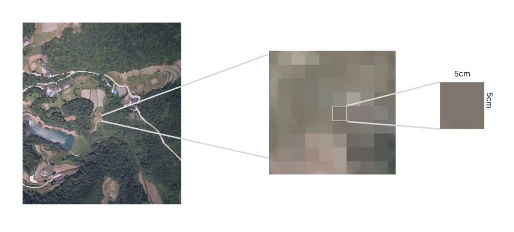
Ground Sample Distance, also known as Ground Sampling Distance, often abbreviated as GSD, refers to the distance between the centers of two consecutive pixels on the ground as captured by a drone's camera. In simpler terms, it is the actual size of one pixel on the ground.
For instance, if the GSD is 5 cm, each pixel in the image represents a 5 cm by 5 cm square on the ground. This metric is crucial because it directly impacts the level of detail and accuracy in the images and maps produced by drones.
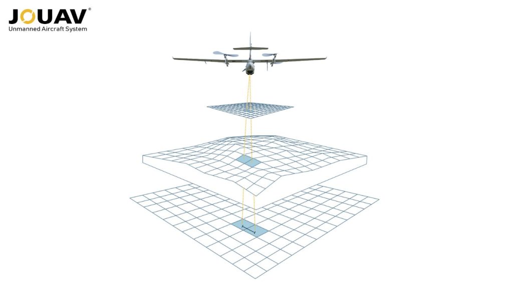
A common misconception is that GSD only applies to the ground surface. However, GSD is relevant to any surface captured by the drone, whether it's a building facade, a roof, or any other vertical structure.
For example, in roof inspections, the GSD is calculated based on the roof's surface area rather than the ground. This broader application is why sometimes it might be more accurate to refer to it as "surface sampling distance" rather than just ground sampling distance.
How GSD Impacts Accuracy in Drone Mapping?
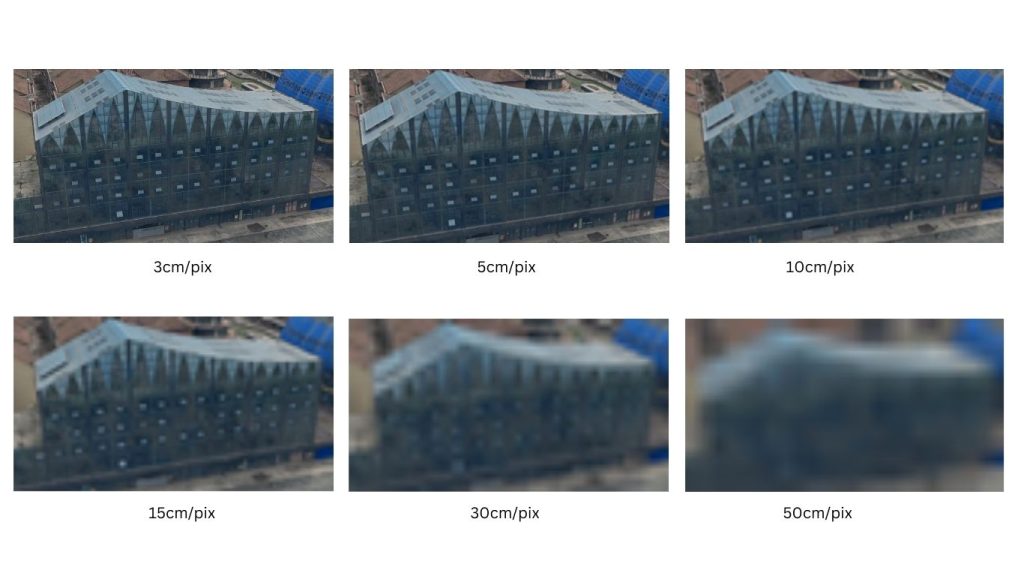
In drone mapping, GSD is used to quantify the spatial resolution of aerial imagery. A smaller GSD indicates higher resolution, meaning more detail is captured in the image.
Conversely, a larger GSD signifies lower resolution, with less detail visible. The GSD is determined by factors such as the altitude of the drone, the focal length of the camera, and the sensor size.
A Comparison Table Between Low and High Ground Sample Distance:
| Feature | Low GSD | High GSD |
| Pixel Size | Smaller | Larger |
| Image Detail | Higher | Lower |
| Data Accuracy | Higher | Lower |
| Flight Altitude | Lower | Higher |
| Image Capture | More images | Fewer images |
What is the Difference Between GSD and Spatial Resolution?
GSD and spatial resolution are often used to describe image quality and detail, but they refer to different aspects of image data.
Definitions
Ground Sampling Distance (GSD) defines the size of a single pixel in an image as measured on the ground.
This metric is calculated using the sensor's focal length, sensor array dimensions, and the distance between the sensor and the ground at image capture, typically indicated by the altitude of the aircraft or satellite.
On the other hand, spatial resolution encompasses the size of pixels within an image relative to real-world objects or terrain features in focus.
Unlike GSD, which focuses on ground-level pixel dimensions, spatial resolution varies based on object distance from the sensor. Objects closer to the sensor appear more detailed, while those farther away may appear less detailed.
Measurement Focus
GSD is a direct measure of the ground distance represented by each pixel. A smaller GSD indicates a higher-resolution image, meaning more details can be discerned.
Spatial Resolution is about the sensor’s capability to distinguish between closely spaced objects. A higher spatial resolution means the sensor can detect smaller objects or details in the image.
Variability
In a scenario where the ground is flat (scenario 1), the distance (D) between the sensor and the ground is consistent across the image, resulting in equal spatial resolution and GSD throughout the scene.
However, in scenarios where objects vary in height or the image includes areas with variable surface relief (scenarios 2 and 3), spatial resolution diverges from the calculated GSD. Objects closer to the sensor exhibit higher detail, while those farther away show lower detail.
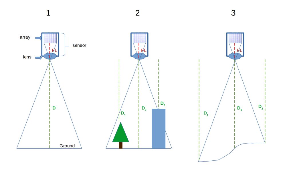
Image credit: stackexchange.com
Precision Planning
The fundamental importance of GSD lies in its direct impact on survey accuracy. GSD serves as a cornerstone for surveyors to meticulously plan their drone flights.
It dictates essential parameters such as the altitude from which the camera will capture images and specific camera settings like sensor width, focal length, and image resolution.
Note: It's important to remember that GSD can be affected by variations in elevation across the survey area. For instance, flying over a large pit or a tall mound can impact the consistency of GSD across the entire model.
What is the Ideal Ground Sample Distance?
Determining the ideal Ground Sample Distance (GSD) depends on the specific application, which can be broadly categorized into two groups: mapping and inspection. The GSD required for each scenario varies based on the level of detail and accuracy needed.
Precise Mapping
A lower GSD value translates to a more accurate survey. Your survey's accuracy cannot exceed the GSD. For UAV photogrammetry, the typical GSD range falls between 1.5 to 2.5 cm/px (0.6 to 1 inch). Professional surveys often recommend a GSD of 1 cm/px for optimal accuracy, though this is quite low.
High-Detail Inspections
For tasks that require highly detailed inspections, such as analyzing cracks in a building facade, identifying individual roof shingles, or inspecting for corrosion on power lines, a lower GSD (ideally below 1 cm) is recommended. A finer GSD allows for zooming in and seeing fine features with greater clarity.
Ideal GSD Ranges for Common Applications:
| Application | Ideal GSD Range | Focus |
| Facades/Roofs Inspections | 1 cm or less | Capture cracks, defects, material condition |
| Construction Site Monitoring | 1.5 - 2.5 cm | Monitor progress, identifying potential issues |
| Stockpile Volume Calculations | 5 - 10 cm | Accurately estimate stockpile volumes |
| Topographic Mapping | 1 - 5 cm | Map terrain features, creating elevation models |
| Environmental Monitoring | 8 - 15 cm | Monitor vegetation health, identify changes |
| Large Scale Urban Planning | 10 cm | Capture broad geographic features |
Read More


Every drone needs a brain.
Without it, you’re holding an expensive paperweight with spinning blades.
That brain is called a flight controller—but most people have no idea what it actually does.

Let’s be honest: the drone world loves its acronyms. UAV, UAS, drone, RPAS, UCAV, FPV–it’s an alphabet soup. And most people use them like they’re the same thing.
They’re not.
And here’s why that matt

JOUAV Product News and Use Cases
Fixed-Wing VTOL Drones Insights and Industry Trends
Invitations to online demo events