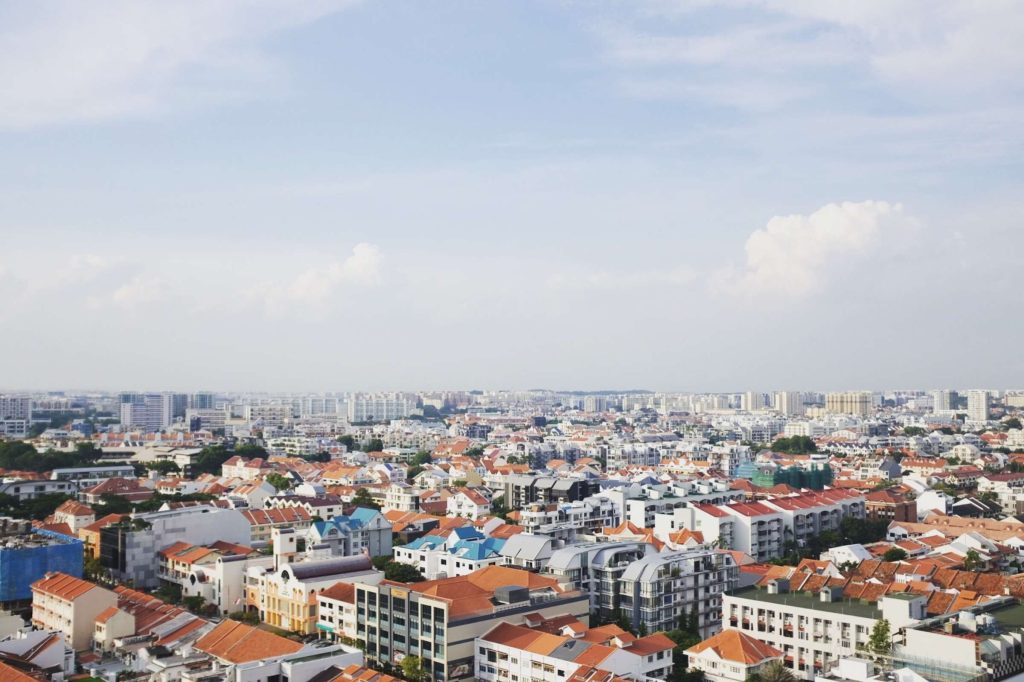
More and more people are using commercial drones for 3D mapping.

3D modeling drones capture data from the air and can do many things that traditional surveying can't - record all objects quickly and accurately.

Using photogrammetry software, you can stitch the data into an accurate 3D model.

There, any captured information can be easily viewed and retrieved.

Drone 3D models have been widely used for urban planning, traffic control, mobile telecommunication design, etc.

However, creating high-quality 3D models that look great from all angles is not as simple as buying an excellent survey drone. There’s a bit more to it.

In this article, we'll explain everything you need to know about 3D drone mapping and modeling, including what a drone 3D model is, which is the best 3D mapping drone, and how to create a 3D model from drone images.

Let's dive right in.

drone 3D mapping

What is drone 3D mapping and modeling?

What is drone 3D mapping and modeling?

Drone 3D mapping refers specifically to the process of capturing oblique images by drones through the use of laser scanning and aerial photogrammetry techniques. 3D modeling, on the other hand, uses specialized software to analyze and process the aerial images captured by the drone to create a 3D model with GPS coordinates and precise measurements.

What is a 3D model?

What is a 3D model?

A 3D model is created by drawing individual points on the X, Y, and Z axes of 3D space to create a 3D representation of an object. These points are connected by different geometric forms, such as triangles, lines, curved surfaces, etc., to form the model.

Why drones are great for aerial photogrammetry?

Why drones are great for aerial photogrammetry?

The benefits of utilizing aerial photogrammetry are plentiful, whatever the applications.

First, drone photogrammetry easily captures data in areas that are difficult or unsafe for surveyors to reach, including places with severe landslides, crime or war, difficult-to-navigate terrain, and harsh weather conditions. This reduces the potential for crew injuries.

Second, equipped with high-resolution cameras, drones can capture sharp and detailed photos. If RTK/PPK is enabled, the drone can provide highly accurate survey results.

  • Read more: What is an RTK drone? How does it work?

Third, drones can reduce the time spent on field surveys. Photogrammetry with drones is five times faster than terrestrial methods and does not require the placement of many GCPs. this allows you to deliver your survey results faster.

Finally, drones bring a dramatic reduction in cost, rather than the high cost of hiring full equipment such as helicopters and cranes. Drones are easy to operate, cost a fraction of a manned aircraft, and eliminate huge fuel and labor costs.

Drone for 3D mapping

Best drone for 3D mapping and modeling

Best drone for 3D mapping and modeling

Are you looking for the best drone 3D mapping drones? But not all drones are made for 3D mapping. Here we will show you some of the best 3D modeling drones you can buy.

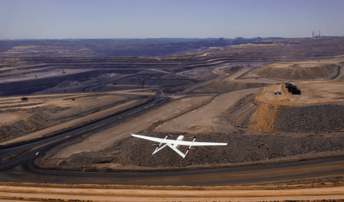
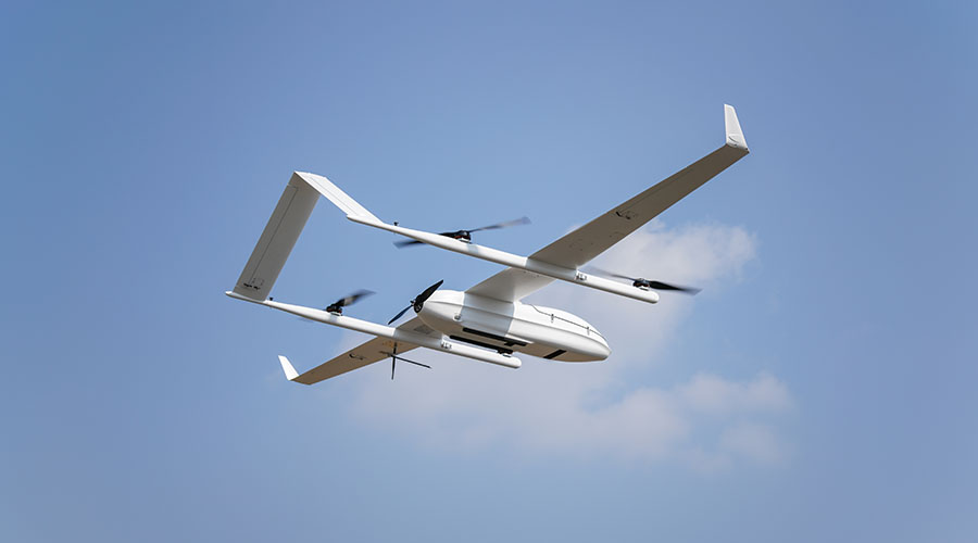
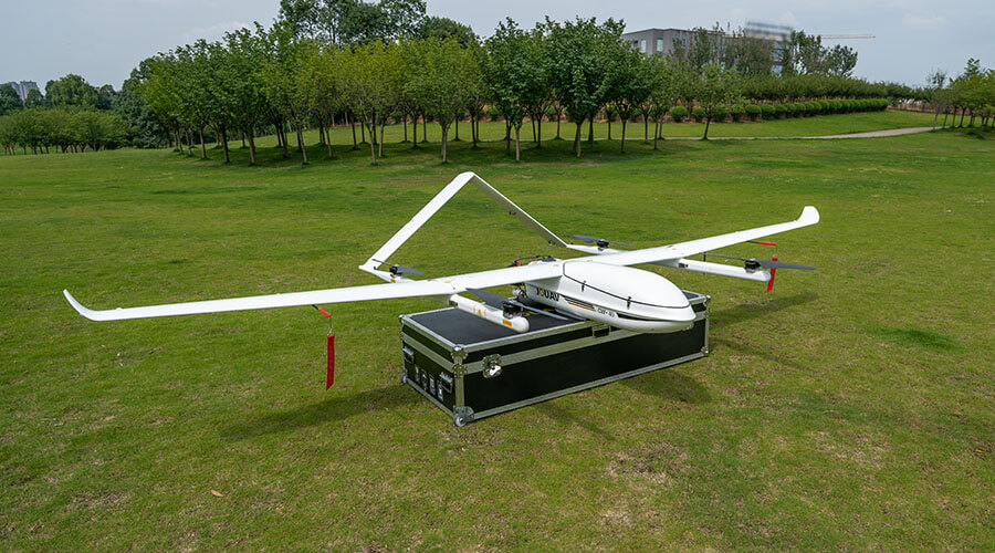
JOUAV CW-15: Best entry-level drone for 3D mapping

The JOUAV CW-15 is a vertical take-off and landing (VTOL) fixed-wing drone specifically designed for 3D mapping. It offers a flight time of up to 180min and a cruising speed of 61km/h, making it the best choice for mapping tasks as it can cover a large area in a short time. With a range of up to 50km, the CW-15 allows you to cover a large area without worrying about losing the signal.

The CW-15 can lift different loads of 3kg in weight. It can carry both a 155MP five-lens oblique camera for 3D surveys, a 50MP medium-format camera to capture orthophotos, and a LiDAR sensor to achieve centimeter-level 3D point clouds.

It has a compact design, as well as advanced obstacle avoidance features and an intelligent landing system, enabling surveyors to capture more complex scenes while safeguarding the CW-15 from more obstacles.

CW-15 drone for 3D mapping

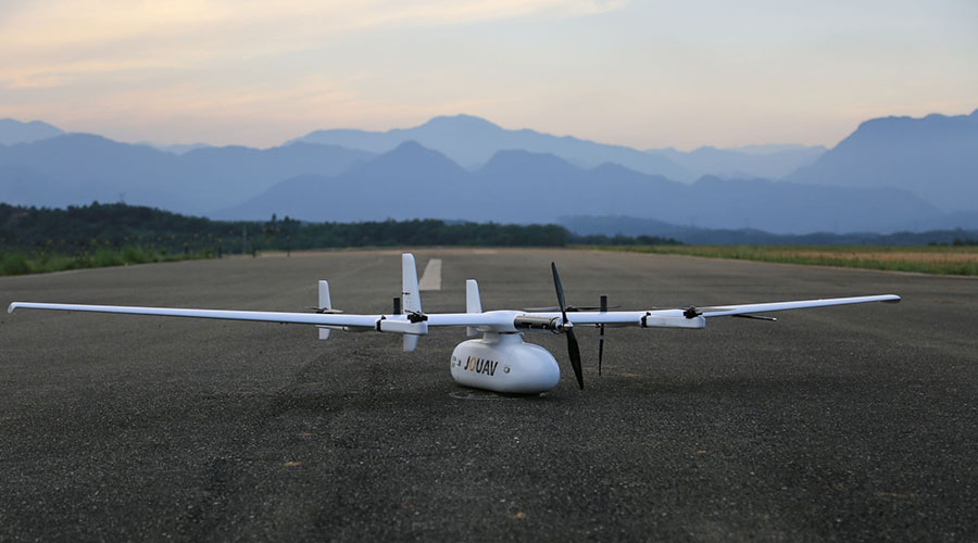
JOUAV CW-25E: Best drone for photogrammetry

The JOUAV CW-25E is a top-notch 3D model drone that offers impressive flight time, range, speed, and camera quality. Thanks to its powerful motor and large battery, the CW-25E offers 240min flight time and 72km/h on a single charge, which gives you enough time to cover a large area or get detailed photos or videos of a specific location.

With its self-developed PPK and RTK GNSS modules, the CW-25 photogrammetry drone can achieve best-in-class vertical accuracy down to 1cm while reducing ground control points by more than 80%.

With a range of 50 or 100km, the CW-25E allows you to explore more of your surroundings and capture stunning images. This camera also records and outputs GPS coordinates and attitude angles at the time of exposure, providing you with the best 3D mapping solution.

3D modeling drone - CW-25E

JOUAV CW-30E: Best drone for GIS mapping

The CW-30E is a hybrid electric and gas powered drone for GIS mapping, providing centimeter-level positioning accuracy. It is specifically designed for mapping and its integrated RTK and PPK modules provide industry-leading positioning performance.

With a four-stroke EFI engine, the 3D modeling drone has a flight time of 600min and a cruising speed of 90km/h. The CW-30E also has a range of 200km, so you can explore your surroundings to your heart's content without worrying about running out of battery or losing the signal.

Its large cabin space, extensive mechanical and electrical interfaces, and load capacity of up to 10kg allow it to carry a variety of mission loads such as aerial cameras, oblique cameras, LiDAR sensors, and dual thermal cameras. In addition, the CW-30E can take off and land anywhere, whether on a cliff, in the woods, in the mountains, or even on a moving boat or vehicle.

CW-30E 3D model drone

Drone 3d modeling software

Drone 3d modeling software - Pix4D Mapper

Pix4D Mapper is a PC application focused on 2D orthomosaic and 3D model reconstruction. It is equipped with LiDAR point cloud processing, orthomosaic map stitching, 3D modeling, and more features. Its comprehensive reconstructed models are targeted at applications such as topographic mapping, power, emergency services, construction, transportation, and agriculture.

What is drone 3D mapping used for?

What is drone 3D mapping used for?

Since drone 3D models provide users with richer geographic information and a more user-friendly experience, the technology has been used in many different industries.

  • Urban planning. By comparing 3D maps from different periods, relevant departments can detect buildings that have changed (such as new buildings) and can measure the areas that have changed, providing favorable evidence for demolition work. Read the real-world case study of the Weinan 3D modeling project.
  • Architecture and landscape design. The team often uses photogrammetry to create accurate 3D models of public spaces. Using these models, they can study the urban landscape and influence new designs.
  • Farmers can use 3D models of farmland to better understand the topography and soils of the area. Drones are particularly useful for companies managing large areas of land, helping to identify problems such as soil erosion and crop diseases.
  • Construction industry. The construction industry uses drone 3D models to track and document project progress and help communicate site layouts, including the location of landscape elements and utility equipment. These 3D model drone inspections are also ideal for facility maintenance, such as backhoes, bulldozers, and excavators.
  • Real Estate Management. Real estate companies use 3D maps of properties that associate service titles and registries with spatial locations to provide a reliable basis for future change comparisons.
  • Equipment Inspections. Energy companies are using 3D models to inspect the condition of transmission towers, bridges, or cell towers from a safe distance. A full 360° view of all critical components gives your team the ability to analyze potential issues.
  • Environmental monitoring. Forest service groups use drone 3D models to study invasive plant production and forest fire. Environmental inspectors can predict the likelihood of a disaster and help with disaster recovery tasks after a flood or hurricane event.
  • Public safety. Using drone 3D models, law enforcement agencies can find the approximate hiding places of suspects and plan their arrests. In emergency situations, the data can also help first responders plan evacuation routes and enable rescue teams to locate missing persons and save lives.
How much does a drone 3d mapping cost?

How much does a drone 3d mapping cost?

How much a drone cost is one of the most common questions in the drone form. Intermediate drones for mapping cost less than $2,000, but can only perform basic levels of mapping. Serious mapping equipment will cost anywhere from $10,000 to $100,000.

How do you create a 3D model from drone images?

How do you create a 3D model from drone images?

Are you stuck with making a 3d model from drone photography? Here is a step-by-step guide to help mappers and architects convert drone photos into 3D models or maps

Step 1: Get a drone with a high-quality camera. The quality of the photos captured by the drone affects the clarity and accuracy of the 3D maps and models. JOUAV's CW Series VTOL drones combine RTK and PPK modules that are often used for aerial photogrammetry.

Step 2: Set up Ground Control Points (GCPs). GCPs are black and white square points placed on the ground around the survey site to serve as reference points for the UAV pilot. The pilot can easily determine the area to be captured in the field based on the GCPs when operating the drone, which can greatly reduce the error during the survey.

Step 3: Set up the drone and camera. Before taking off, you need to perform a pre-flight check and double-check everything. Make sure that your drone has enough battery life, and the memory card has enough storage space, and set your camera angle, aperture, and shutter speed.

Step 4: Check the weather report. If you don't want to jeopardize your equipment, you should make sure you're surveying on a sunny day, avoiding rain and cloudy days. In addition to that, you need to choose a time of day when the light is good, such as sometime around noon.

Step 5: Choose a suitable 3D drone modeling software and use it to process your data. Professional photogrammetry software, such as Pix4Dmapper, can help you process your data into a 3D model. If you are not very good at processing drone data yourself, you may also consider outsourcing this part of the work to a professional. GIS experts are more than capable of handling drone data to ensure the end result meets your requirements.

Tips for improving the accuracy of your drone maps and 3D models

Bonus tips: How to improve the accuracy of your drone maps and 3D models?

To create accurate 3D models, you need to do the following two things.

First, you need to make sure that your aerial photos have 60 to 70 percent overlap, which here includes lateral overlap and frontal overlap. This suggested overlap for drone 3d mapping is to make the triangulation process more accurate by tracking the same points between images.

Secondly, you need to make sure the drone captures more detail of the landscape at different angles and altitudes, so more data points are available. Also, try to have the drone fly at lower altitudes so you can get clearer images.

Share :
Read More
thumbnail
Millions lost, projects delayed: Construction site theft is a costly reality. According to the National Equipment Register,a staggering $300 million to $1 billion lost annually in stolen construction
thumbnail
Have you ever wondered why Greenland appears larger than South America on a world map? This is a prime example of map distortion, a necessary consequence of transforming our spherical Earth onto a fla
thumbnail
Our modern world relies on hidden resources – the metals in our phones, the minerals in buildings, and the coal that once powered our societies. However, extracting these materials has an environmenta