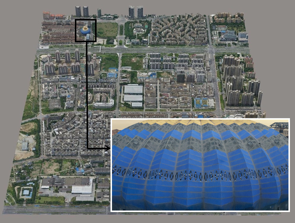
Yeah, you’ve probably seen those LiDAR maps—the ones that strip away trees to reveal ancient ruins or show cityscapes in stunning 3D detail. They’re impressive.
But here’s a question
Have you ever wondered what makes those stunning maps, aerial photos, and survey data so incredibly precise?
It's the unsung heroes of the geospatial world - Ground Control Points (GCPs).
These seemingly inconspicuous markers play a crucial role in ensuring the accuracy of your geospatial information.
But what exactly are Ground Control Points, and why do they hold such a significant place in georeferencing? How to set up ground control points?
Let's begin our journey of discovery to unravel these secrets and more.
Types of Ground Control Points
Different types of GCPs are used in control point surveying for drone mapping and other applications to maximize georeferencing accuracy. Here are some common types of drone ground control points:
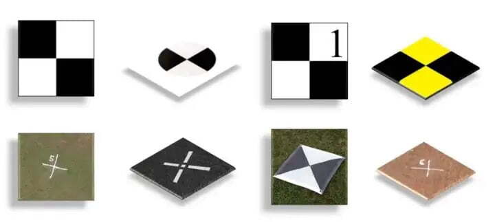
Source from surveyaan.com
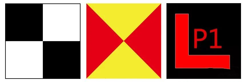
Black and white checkerboard squares: Sometimes, simplicity is key. Using bright orange spray paint to create large X-shaped markings on the ground is a straightforward yet effective GCP method. The vivid orange color against the natural backdrop ensures that drones can easily spot and capture these markings for georeferencing.
Orange spray paint in the form of an X: The use of orange spray paint to create large X-shaped markings on the ground is a simple yet effective GCP strategy. The bright color contrast between the orange X and the natural surroundings ensures that drones can detect and capture these markings, making them ideal for georeferencing.
White V shapes: White V-shaped markers offer a distinct pattern that's visible from the air. Whether you're using standard RGB or multispectral imagery, these markers are easy to spot. This makes them an excellent choice for georeferencing in various mapping and surveying scenarios.
1 m × 1 m black squared GCPs with white opposite facing triangles: These GCPs consist of a 1-meter by 1-meter black square with white triangles pointing in opposite directions. The combination of contrasting colors and unique geometry ensures that drones equipped with cameras and sensors can easily detect and reference them, providing high accuracy.
White circular (0.30 m diameter) GCPs with concentric black rings: Circular GCPs with concentric black rings offer a distinctive visual pattern. These GCPs are often used in photogrammetry and aerial photography applications where precision in georeferencing is crucial. The circular shape and concentric rings provide a clear reference point for the drone.
What Are Ground Control Points Used For?
Ground Control Points serve several important purposes in geospatial and remote sensing applications:
Cartography and Mapping
The field of cartography relies heavily on GCPs to create precise and reliable maps. GCPs enable cartographers to transform two-dimensional representations of the Earth's surface into an accurate, three-dimensional model. This accuracy is essential for producing navigational maps, topographic maps, and thematic maps used in urban planning, environmental management, and disaster response.
Remote Sensing and Satellite Imagery
In remote sensing and satellite imagery, GCPs are indispensable for correcting distortions and inaccuracies introduced by various factors. These factors include camera lens distortion, satellite orbits, and terrain elevation variations. GCPs facilitate the precise alignment of captured images with the Earth's surface, allowing for accurate analysis, change detection, and resource management.
Infrastructure and Construction
The construction and infrastructure sectors heavily rely on GCPs for accurate surveying and project management. GCPs help ensure that construction projects, such as roads, bridges, and buildings, are built in the right location and conform to design specifications. They aid in land surveying, site preparation, and quality control.
Natural Resource Management
In the context of natural resource management, GCPs contribute significantly to monitoring and analyzing changes in the landscape. They assist in precise measurements related to deforestation, urban expansion, changes in water bodies, and shifts in vegetation cover. This data is crucial for informed decision-making in conservation, land use planning, and environmental protection.
When Do You Need Ground Control Points?
The necessity for GCPs depends on the scale and accuracy requirements of your geospatial project. Here are some scenarios in which GCPs are essential:
High-Precision Mapping
When your mapping project demands a high level of accuracy, especially in applications such as land surveying, cartography, or infrastructure planning, incorporating GCPs is essential. High-resolution satellite imagery or aerial photographs can be aligned with ground truth data using GCPs, ensuring that every feature on the map is accurately represented.
Large-Scale Projects
In large-scale geospatial projects covering extensive areas, the Earth's curvature and terrain variations can cause distortions in imagery. GCPs help correct these distortions, allowing for precise measurements and analysis. Large-scale applications include urban planning, forestry management, and agricultural monitoring.
Change Detection
When monitoring changes over time, such as urban development, deforestation, or glacier movement, GCPs aid in detecting subtle shifts in the landscape. By providing a stable reference frame, GCPs enhance the accuracy of change detection analyses, allowing for reliable assessments of environmental changes.
Integration of Diverse Data Sources
In cases where data is collected from diverse sources or sensors, ground control points ensure consistent alignment. They serve as a bridge to harmonize data, enabling smooth integration and analysis. This is particularly relevant in multi-sensor remote sensing projects or when merging aerial and satellite imagery.
Absence of RTK or PPK Correction
One primary scenario demanding the use of GCPs is when your aerial survey data is not corrected in real-time or post-process by real-time kinematic (RTK) or post-process kinematic (PPK) methods. Without these correction techniques, the inherent accuracy of standalone GPS data can only be achieved within a few meters. However, for precise mapping and surveying, this level of accuracy often falls short. In such cases, GCPs become indispensable to improve the overall accuracy of your mapping results.
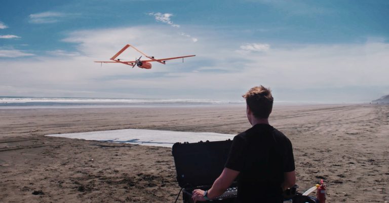
RTK and PPK-equipped drones like JOUAV CW-007 have transformed aerial surveying by integrating highly accurate positioning technology, often reducing the number by over 80% in comparison to non-PPK drones. These drones can achieve 1cm (0.4 in) absolute accuracy, minimizing GCP deployment.
What is a Good Ground Control Point?
Not all ground control points are created equal, and to be effective, they must meet a comprehensive set of criteria. In this detailed section, we will explore what makes a good ground control point.
Size and Visibility
An optimal GCP should measure about half a meter by half a meter (2 feet by 2 feet) to ensure visibility from aerial altitudes. Painted with high-contrast colors like black and white, orange, yellow and black, or bright green, GCPs stand out clearly against the natural environment.
Additionally, they should have a matte finish to reduce glare and reflections in the imagery. A clear corner or center as the point enhances their identifiability in aerial imagery.
Distinctiveness and Identifiability
Distinctive shapes, such as squares or crosses, are preferred for GCPs. These shapes are unlikely to occur naturally in the environment, making them easily identifiable.
Beyond basic contrasting colors, the GCP should also contrast sharply with its immediate surroundings in terms of color and texture. This stark contrast aids automated algorithms in precise identification.
Durable Materials
To ensure the longevity of GCPs and their visibility in various weather conditions, it is recommended to use durable materials. Paint or vinyl flooring tiles are commonly employed for this purpose.
When using vinyl tiles, it is advisable to apply construction glue to secure them to the ground firmly. This prevents displacement caused by environmental factors like wind or rain, ensuring the stability of the GCP.
Location Accuracy
A GCP must be placed at a location where its ground coordinates can be determined with utmost precision. Advanced tools like GPS receivers or total stations are employed to establish accurate real-world coordinates.
The point should be situated in such a way that its location can be accurately determined at the resolution of the raw image. This ensures that the GCP can be precisely matched to its corresponding pixel in the imagery.
Avoiding Confounding Factors
GCPs must be placed on permanent features, avoiding non-permanent elements like seasonal changes, temporary structures, or vegetation that may alter over time. Shadows, which shift with changing sunlight angles, can create confusion in identifying the true location of a GCP and should be avoided.
Furthermore, GCPs must not coincide with repetitive patterns like periodic lines along roads or markings on surfaces, as these features can introduce ambiguity, making it difficult to pinpoint the exact location of the GCP.
How to Lay Ground Control Points?
When setting up GCPs, it's essential to follow specific principles and guidelines to guarantee reliable results. This section will outline the key considerations and steps for laying GCPs effectively.
Layouts for Varied Flight Areas
When it comes to setting up Ground Control Points (GCPs), an essential principle is to strategically distribute them across the surveyed area while avoiding linear arrangements. This approach is crucial for eliminating any georeferencing bias and reducing errors in the mapping process.
Here's how to optimally lay out GCPs for different types of flight areas:
Regular Rectangles and Squares: For smaller areas, it's recommended to place a minimum of five control points. These should be positioned at each of the four corners of the flight area and one in the center. In cases where the area is extensive and has a regular shape, you can arrange GCPs in a zigzag pattern.
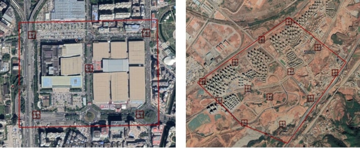
Irregularly Shaped Areas: Often, the terrain results in irregularly shaped flight areas. In such situations, the key is to adapt the placement of control points according to the natural contours of the landscape. This ensures even coverage across the entire measurement area.
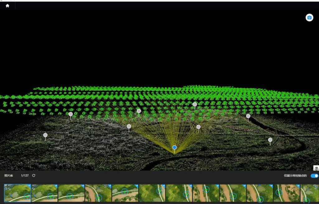
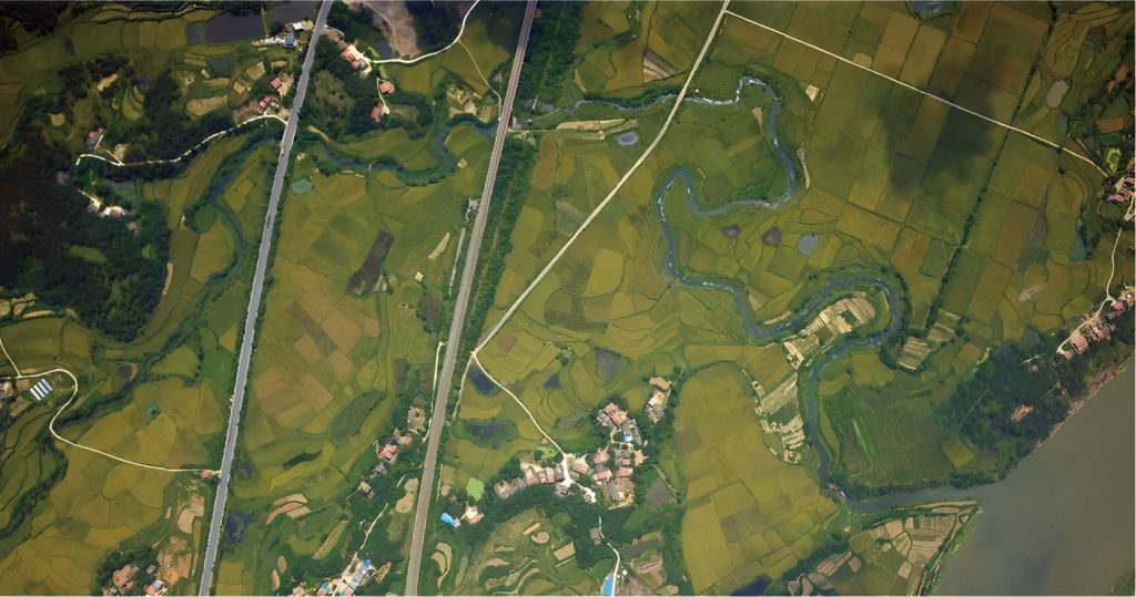
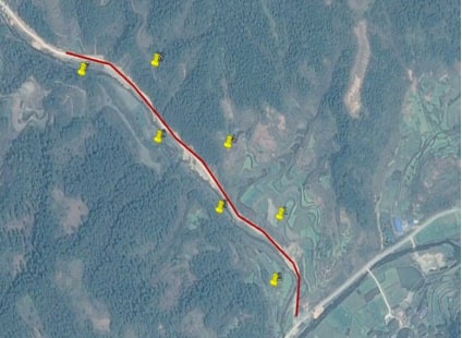
Strips, Rivers, Highways, and Similar Areas: In these instances, a commonly used layout involves an "S" or "Z" pattern. This means placing two control points perpendicular to the strip on both sides and one control point in the center of the strip, as demonstrated in the accompanying figure.
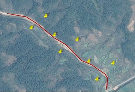
An alternative "S" pattern provides flexibility but may compromise elevation accuracy. Consider this approach based on specific project needs.
Prevent the "Dome-ing" Phenomenon
In drone mapping, the "dome-ing" phenomenon, akin to securing a tarp at its corners in the wind, can introduce distortion. To mitigate this, distribute GCPs strategically across the mapping area. Place one or more GCPs in addition to the corner points, especially in areas with significant terrain changes. These additional GCPs anchor the aerial imagery, enhancing accuracy.
Consider the Inverse Relationship of GCP Accuracy
The accuracy of your survey is inversely proportional to the distance from the GCP. In other words, areas near a GCP will be very accurate, while those farther away will have lower accuracy. To manage this effect, consider defining an imaginary circle with a radius of 200 meters around each GCP. Areas outside this circle are considered to have lower data quality.
It's important to note that the 200-meter radius is a general guideline and may vary depending on the camera or drone being used. High-end cameras may allow for larger radii, while lower-end equipment, such as the Mavic Mini, might require a smaller radius.
Account for Changes in Elevation
In survey areas with significant changes in elevation, it's crucial to place GCPs at both the highest and lowest points of the site. Elevation differences can introduce errors in survey data, particularly in hilly or mountainous terrain. Carefully positioned GCPs that span different elevations help minimize these discrepancies and enhance the overall accuracy of the mapping project.
Additional Considerations
Field of View: When situating control points, it's crucial to choose spots with clear views and minimal obstructions. Ideally, position them at a 45° angle to the ground, ensuring the flying drone captures them effectively.
Strategically, consider placing GCPs at crosswalk corners or the upper corners of buildings. These distinct locations simplify data post-processing later on.
Avoid placing control points near utility poles, parking lots, or areas with substantial shadows. These conditions can obscure visibility and impact the accuracy of your survey data.
Slope: Avoid placing control points in areas with steep slopes, as deviations during point marking may be amplified, potentially affecting model accuracy.
Anticipated Damage: Consider areas where GCPs may be susceptible to damage, such as construction sites or locations close to residential buildings.
Control Point Size: Customize the size of control points based on different flying altitudes, accuracy requirements, and overlap rates. Anticipate how control points will appear from the drone's altitude to avoid post-processing complications.
Overlap: Control points should be positioned to be shareable between multiple images, typically within 5 to 6 image overlaps. Ensure a sufficient distance from image edges and markings to prevent potential inaccuracies.
Maintain a buffer of at least 150 pixels from the image edges. This precautionary measure prevents control points from being too close to the image borders, minimizing the risk of inaccuracies creeping in.
The distance between control points and image markings must exceed 1 millimeter. This guarantees distinct visibility of control points within the images, aiding accurate data correlation.
Ideally, position control points along the central line of lateral overlap. If there's a lack of lateral overlap, extra points might be necessary. However, ensure the vertical distance between control points is less than 2 centimeters. This approach enhances survey precision, even with reduced lateral overlap.
How to Choose Ground Control Points?
In situations where traditional ground control points are unavailable, natural landforms or landscape features can serve as reliable markers for GIS mapping.
These features must be situated on the ground in an open environment to ensure their visibility in the original images. The proximity of tall structures, like buildings or trees, should be avoided, as they can obstruct the point in the ortho-ready image. Opting for locations on flat terrain enhances the expected accuracy of the digital elevation model (DEM) at the GCP's position, which is a crucial factor influencing the quality of the orthorectification process.
Additionally, it's crucial to select points with distinct contrast compared to their surroundings. For example, consider features like road markings or the intersection of asphalt and concrete sidewalks, where there's a significant difference in color.
When choosing natural features as reference points, prioritize relatively large ones. Accompany your selection with 2 to 4 on-site photographs to clearly illustrate their positions. These photographs should include at least one close-up image of the point and another providing context of the surrounding area.
In cases where you need to mark these features with spray paint, ensure a minimum width of 30 centimeters and sharp angles for clarity. This ensures visibility and accuracy in subsequent geospatial processes.
Ground Control Points Examples
The following comprehensive GCP setups take into consideration the specific requirements and challenges of each project, ensuring that accurate georeferencing is achieved and maintained during the course of the work.
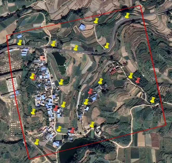
Example 1: Mapping an 80-acre Urban Redevelopment Area
Mapping an 80-acre urban redevelopment area for planning and construction purposes.
- Utilize 17 Ground Control Points (GCPs) and 5 Checkpoints for high-precision mapping.
- Place GCPs as follows: Four GCPs at the corners of the redevelopment area to establish a precise boundary reference.
- Distribute the remaining 13 GCPs evenly throughout the site to ensure accurate mapping of details and features.
- Ensure GCPs are positioned in areas with different terrain characteristics.
- Set up GCPs at elevated points, and areas with significant elevation changes, to account for topographic variations.
- GCPs should be located at least 30 meters from the site boundary to avoid edge effects.
- Deploy 5 checkpoints within the area at locations representing different sections of the redevelopment site.
- Accurately record GPS coordinates for each GCP and checkpoint.
- Implement highly visible markers or surveying monuments to facilitate easy identification during data collection.
- Regularly check the stability and integrity of the GCPs and checkpoints throughout the project.
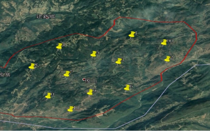
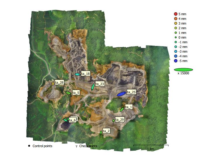
Example 2: Surveying a 1500-acre Open-Pit Mine
Surveying a large 1500-acre open-pit mine for monitoring shifts in the pit and coal production.
- Utilize 29 Ground Control Points (GCPs) to accurately monitor shifts and changes in the open-pit mine.
- Place GCPs strategically: Position GCPs near the mine's boundaries and in areas prone to geological movement or related to coal production.
- Distribute GCPs to capture key aspects of the mining operations, ensuring coverage of different operational sections.
- Consider placing GCPs at elevated points and in locations with significant terrain changes.
- Record highly precise GPS coordinates for each GCP, preferably using real-time kinematic (RTK) GPS equipment.
- Implement permanent, well-maintained ground markers or monuments to serve as reference points for ongoing monitoring.
- Regularly survey and verify the stability and accuracy of GCPs in a dynamic mining environment.
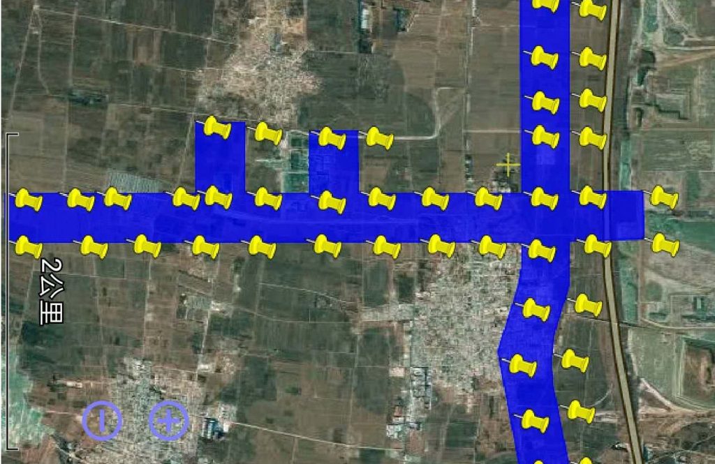
Example 3: Statewide Transportation Infrastructure Project (11 Miles of Highways)
Conducting a survey for a statewide transportation infrastructure project covering 11 miles of highways.
- Utilize 9 Ground Control Points (GCPs) to ensure accurate georeferencing across the 11-mile stretch of highways.
- Position GCPs strategically: Place GCPs at entry and exit points, major intersections, and other significant landmarks along the highway.
- Distribute GCPs to cover areas with different terrain characteristics, including elevation changes.
- Space GCPs at intervals of approximately 1.5 miles to maintain surveying accuracy over the entire project.
- Record highly precise GPS coordinates for each GCP, employing high-precision surveying equipment such as RTK GPS.
- Implement clear and highly visible ground markers or survey control points to ensure easy identification by field surveyors and construction teams.
- Regularly monitor and maintain GCPs to ensure their integrity and accuracy throughout the project's duration.
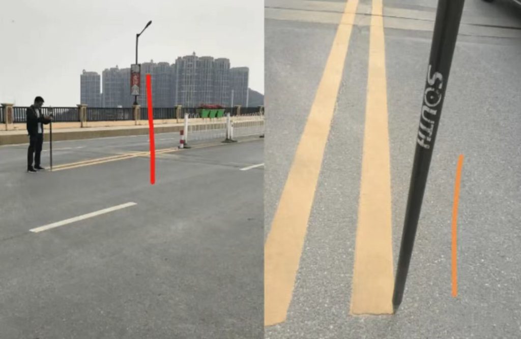
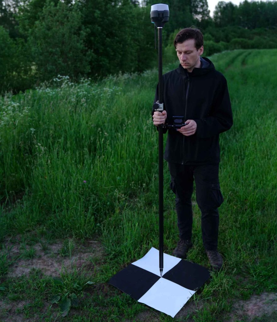
How to Measure GCP Positions?
After placing GCPs, the next crucial step is to accurately measure their positions. This is typically done using Real-Time Kinematic (RTK) or Post-Processed Kinematic (PPK) capable GNSS (Global Navigation Satellite System) receivers. These high-precision GNSS systems provide accurate positional data for the GCPs.
Step 1: Prepare Your Equipment
Before you start measuring GCP positions, ensure that you have the following equipment and software ready:
- RTK or PPK GNSS Receiver: Make sure you have a high-precision GNSS receiver capable of RTK or PPK corrections. These receivers should be well-maintained and calibrated.
- Survey Pole or Tripod: A stable support system is necessary to hold the GNSS receiver at a fixed height above the GCP.
- Data Collector or Tablet: You'll need a data collector or tablet with GNSS software to monitor and record the receiver's position.
- Survey Control Points: These are known points with accurately determined coordinates. They are used as reference points for your GNSS receiver to correct its measurements. The accuracy of your GCP measurements depends on the quality of the control points.
Step 2: Set Up the GNSS Receiver
- Power on the GNSS receiver and make sure it has a clear view of the sky. Ensure it's connected to the survey pole or tripod at a known and constant height above the ground.
- Configure the receiver for your survey. Set parameters such as the GNSS constellation (GPS, GLONASS, Galileo, etc.), correction sources (RTK base station or PPK post-processing), and data logging settings.
- Initialize the receiver by allowing it to acquire satellite signals. This may take a few minutes, depending on your location and satellite visibility.
Step 3: Collect GCP Data
Depending on whether you are using RTK or PPK, the data collection process will differ:
For RTK:
- Establish a connection to a nearby RTK base station. This base station provides real-time corrections to your GNSS receiver, ensuring high accuracy.
- Once the RTK corrections are received, the GNSS receiver will start providing real-time position data. Position accuracy can reach centimeter-level precision.
- Move the GNSS receiver to each GCP location. Hold it steady at a fixed height above the ground (usually around 2 meters) and allow it to collect data for a sufficient amount of time (typically a few seconds to a minute) to achieve high precision.
- Record the position data for each GCP in your data collector or tablet.
For PPK:
- You can move the GNSS receiver to each GCP location without the need for a real-time correction source, as PPK corrections are applied post-survey.
- After completing data collection at all GCP locations, download the raw GNSS data from the receiver.
Step 4: Post-Processing (PPK Only)
If you're using PPK, you'll need to post-process the collected GNSS data to obtain accurate GCP positions. This typically involves the following steps:
- Download and install PPK software on your computer.
- Import the raw GNSS data collected from the receiver into the PPK software.
- Apply the PPK corrections, which can include satellite ephemeris data, atmospheric corrections, and clock corrections.
- Process the data to compute accurate GCP coordinates. The software will provide the final, precise positions for each GCP.
Step 5: Quality Control and Verification
After obtaining GCP positions, it's essential to perform quality control checks to ensure the accuracy of your data. Compare the GCP positions to your survey control points, and if there are discrepancies, investigate and rectify them.
Read More
Let me tell you something that happens way too often.
A company spends $15,000 on a drone, excited about the flight time and range. They get it in the air and mount their LiDAR sensor—and the drone ba

Have you ever watched a drone hover effortlessly over a construction site, inspect a wind turbine blade, or deliver medical supplies to a remote village?
That drone was almost certainly a multirotor.

JOUAV Product News and Use Cases
Fixed-Wing VTOL Drones Insights and Industry Trends
Invitations to online demo events