How to Read METAR Weather Report?
You glance at the METAR report:
KJFK 031452Z 28022G35KT 1/4SM +TSRA OVC005CB 18/16 A2987 RMK AO2
It looks like aviation's secret code—and you're not alone if you feel overwhelmed.
Many aviation trainees find decoding METARs challenging.
Yet these real-time weather snapshots guide over 100,000 daily flights worldwide. Misinterpreting even one element—like confusing BKN008 (800 feet) for 8,000 feet—could lead to flying into low clouds or thunderstorms.
But here's the truth: METARs aren't reserved for experts. Once you learn their logic, you'll unlock critical insights for safer flying—whether you're a student pilot planning a cross-country flight or a drone operator checking conditions.
In this guide, you'll master METARs step-by-step. We'll translate abbreviations like +TSRA (heavy thunderstorm rain) and OVC005CB (dangerously low cumulonimbus clouds), walk through real-world examples, and show you how to spot risks before takeoff.
What is METAR in Aviation?
METAR stands for Meteorological Terminal Aviation Routine Weather Report. It is a standardized format used globally to report current weather observations at airports. These reports are issued hourly, or more frequently when weather conditions change significantly, and are essential for ensuring safe and efficient flight operations.
METARs are not forecasts—they are real-time observations. They include key weather elements such as wind speed and direction, visibility, cloud coverage, temperature, dew point, atmospheric pressure, and any significant weather phenomena like rain, fog, or thunderstorms.
METARs follow the ICAO standard format, making them universally readable by pilots, air traffic controllers, and aviation professionals around the world.
There are two main types of METAR reports:
- Routine METAR: Issued at regular hourly intervals.
- SPECI: A special report issued when there is a significant, unexpected change in weather conditions.
In some cases, a TREND forecast may be appended to a METAR, offering a short-term outlook (usually valid for two hours), although this is used selectively by some countries.
METAR vs. TAF: What's the Difference?
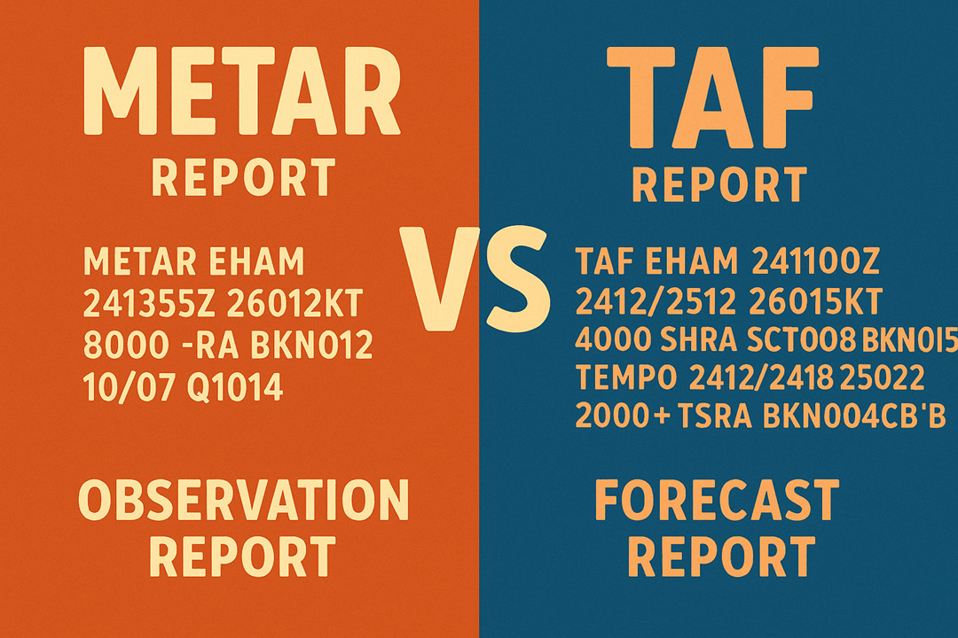
In aviation weather reporting, both METAR and TAF reports are essential—but they serve different purposes.
Feature | METAR | TAF (Terminal Aerodrome Forecast) |
Type | Actual observation | Weather forecast |
Issued | Every hour (or as needed – SPECI) | Every 6 hours (or as needed – amended) |
Validity | Instantaneous, current conditions | Forecasted for 24–30 hours |
Purpose | Describes what's happening now | Predicts what's expected later |
A METAR provides a snapshot of actual weather conditions observed at a specific airport, typically issued every hour. It includes vital data such as wind speed and direction, visibility, temperature, dew point, cloud cover, and significant weather events. With its short validity period, a METAR is best suited for real-time flight decisions—especially during takeoff, landing, or while en route.
A TAF, on the other hand, is a forecast report that predicts weather trends over a 24 to 30-hour window. Issued four times daily, it helps pilots anticipate changes in visibility, wind, precipitation, and ceiling height that may impact future flight operations or route planning.
In simple terms:
- METAR = What's happening now
- TAF = What's likely to happen later
Pilots, flight dispatchers, and drone operators rely on both METAR and TAF to ensure situational awareness, compliance with regulations, and safe, informed decision-making throughout the flight lifecycle.
Why Learn to Read METAR?
METARs play a crucial role in aviation safety and decision-making. By providing accurate, up-to-date weather information, they help:
- Determine whether conditions meet Visual Flight Rules (VFR) or require Instrument Flight Rules (IFR)
- Guide pilots during takeoff, landing, and en-route navigation
- Alert crews to weather hazards such as low visibility, icing, or crosswinds
- Support flight planning and dispatch operations
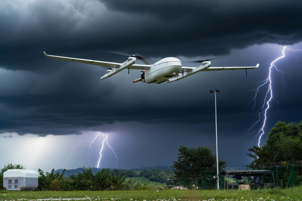
- Enable drone operators to fly safely, especially in controlled airspace or during BVLOS missions
In short, METARs provide the real-time data needed to make safe, informed flight decisions. Without accurate observations, even the best forecasts can fall short.
Step-by-Step METAR Decoding Guide
Trying to decode an entire METAR string at once can be overwhelming. A better approach? Break it down into smaller chunks—each delivering a specific type of weather data. That’s how METARs are designed: concise, structured, and packed with vital information.
Let’s walk through a real-world METAR, breaking it down into 10 core components.
Standard METAR Sequence:
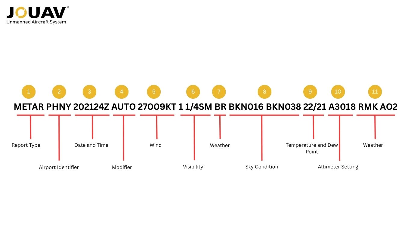
1. Report Type
The report always begins with either METAR or SPECI:
- METAR: Routine weather observation, issued hourly.
- SPECI: Special, unscheduled report due to rapidly changing or hazardous conditions (e.g., thunderstorms, fog, or snow).
Knowing the type immediately tells pilots whether conditions are stable or quickly evolving.
2. Airport Identifier
After the report type, you'll see a four-letter ICAO code that identifies the airport or weather station. Unlike the three-letter IATA codes used for ticketing, ICAO codes are regionally structured and used in flight planning and operations worldwide.
- Continental U.S.: Start with “K” plus the IATA code (e.g., KSEA = Seattle).
- Alaska, Hawaii, Guam, Puerto Rico: Begin with “P” (e.g., PA for Alaska, PH for Hawaii, PG for Guam, TJ for Puerto Rico).
- Canada: Prefixes like CY, CZ, CU, or CW.
- Mexico: Typically MM (e.g., MMMX = Mexico City).
This code ensures that weather data is tied to the correct location—critical in metro areas with multiple airports, such as KAPA (Centennial Airport, Colorado) or VHHH (Hong Kong International).
3. Date and Time
Next comes the date and time of issue. The first two digits (20) correspond to the day of the month, and the last four digits (2124) correspond to the time of issue in hours and minutes.
The "Z" appended to the end signifies Coordinated Universal Time (UTC), also known as Zulu time or Greenwich Mean Time (GMT).
In our example, the METAR was issued on the 20th of the month at 21:24 Zulu time. Pilots are responsible for converting this to their local time.
The timeliness of a METAR is paramount, as reports are generally valid for only one hour.
4. Modifier
This optional element provides context about the report's origin or if it's a correction.
- AUTO indicates a fully automated report generated without human intervention or oversight. Automated stations may further detail their sensor types in the remarks section (e.g., AO1 for no precipitation discriminator, AO2 for a precipitation discriminator).
- COR identifies a corrected report that replaces an earlier one containing an error.
- If no modifier is present, it implies a human observer directly created the report or was actively overseeing the automated system.
Modifiers help assess data reliability. Automated reports can miss subtle or fast-changing conditions, while human observers provide greater accuracy in complex weather like moving fog or storms.
5. Wind
Wind data is presented as a three-digit direction, followed by a two- or three-digit speed, and then "KT" for knots.
- Direction indicates where the wind is coming from, measured in tens of degrees from true north (e.g., 160 means from 160 degrees). Leading zeros are used for directions less than 100° (e.g., 090 for 90°).
- Speed is in knots (KT). Speeds less than 10 KT use a leading zero (e.g., 05KT).
- Gusts are shown with "G" and peak gust speed (e.g., 16005G17KT = 5 knots gusting to 17). Indicates rapid wind variation.
- Variable Wind (VRB) is used if the wind direction is fluctuating significantly (e.g., by 60° or more, or if speed is 3 knots or less, or if direction cannot be determined).
- Calm Wind is reported as 00000KT.
For example, 16005KT indicates wind from 160 degrees at 5 knots. 24015G25KT means wind from 240 degrees at 15 knots, gusting to 25 knots.
Wind information is crucial for runway selection (ideally landing into a headwind), calculating crosswind components, and avoiding dangerous tailwinds.
6. Visibility
This section describes the horizontal visibility at the airport.
In the U.S., prevailing visibility is reported in statute miles (SM), in whole numbers or fractions. An "M" prefix means "less than" (e.g., M1/4SM for less than 1/4 statute mile). The maximum visibility listed is 10 SM, even if it's greater.
Internationally, visibility is often reported in meters (e.g., 0600 for 600 m). 9999 indicates 10 km or more, while 0000 signifies less than 50 m.
At larger airports, especially during low visibility conditions (typically when prevailing visibility is 1 mile or 1600 m or less), Runway Visual Range (RVR) may be reported. This is formatted as R followed by the runway designator (e.g., R07L), then a slash (/) and a four-digit value in feet (U.S.) or meters (international).
A letter may follow the value to indicate tendency: U (upward/increasing), D (downward/decreasing), N (no significant change), or V (variable).
7. Weather
This section utilizes two-letter codes, often preceded by indicators of intensity or descriptors, to describe current weather phenomena. These descriptors add further detailed information, designed to present a fuller picture.
Here is a list of common elements that could be reported:
Code | Meaning | Code | Meaning |
+ | Heavy | BL | Blowing |
- | Light | MI | Shallow |
(no sign) | Moderate | BC | Patches |
VC | Vicinity (5-10 SM from the station) | PR | Partial |
RA | Rain | FG | Fog |
SN | Snow | BR | Mist (visibility ≥5/8SM) |
DZ | Drizzle | HZ | Haze |
GR | Hail | FU | Smoke |
GS | Small hail and/or snow pellets | VA | Volcanic ash |
PL | Ice pellets | DU | Widespread dust |
IC | Ice crystals | SA | Sand |
SG | Snow grains | PY | Spray |
UP | Unknown precipitation | SQ | Squalls |
SH | Showers | FC | Funnel cloud (also tornado/waterspout) |
TS | Thunderstorm | SS | Sandstorm |
FZ | Freezing | DS | Dust storm |
DR | Low drifting | PO | Dust/sand whirls (dust devils) |
This information has a direct impact on flight safety and operational decisions; for instance, thunderstorms must always be avoided. The severity and intensity of precipitation can have serious implications for flight safety.
8. Sky Condition
This part of the report indicates cloud cover levels at various altitudes. It follows a format of a three-letter contraction (describing cloud amount) followed by a three-digit number, which represents the cloud base altitude in hundreds of feet Above Ground Level (AGL). The sky is conceptually divided into eight equal sections, called "oktas," to grade the amount of sky covered.
An example is FEW060 OVC100, meaning few clouds at 6,000 feet and an overcast layer at 10,000 feet. BKN022 OVC050 indicates a broken layer at 2,200 feet and an overcast layer at 5,000 feet.
Code | Meaning | Oktas/Coverage |
SKC | Sky Clear (manual report) | 0/8 (Clear) |
CLR | Clear (automated report, no clouds below 12,000 ft) | 0/8 (Clear) |
FEW | Few clouds | 1-2 oktas |
SCT | Scattered clouds | 3-4 oktas |
BKN | Broken clouds | 5-7 oktas |
OVC | Overcast clouds | 8 oktas (Total sky coverage) |
VV | Vertical Visibility (for obscured sky) | N/A |
The ceiling is defined as the lowest broken (BKN) or overcast (OVC) layer, or the vertical visibility (VV). Cloud cover is critical for flight safety, especially for VFR pilots who generally avoid clouds due to the lack of visibility within them. Clouds can also obscure obstacles and other aircraft, posing significant hazards. Dangerous cloud formations like CB (Cumulonimbus) or TCU (Towering Cumulus) may follow the altitude code, indicating convective activity that pilots must be aware of.
9. Temperature and Dew Point
This section presents two numbers separated by a slash, both in whole degrees Celsius. The first number is the Outside Air Temperature (OAT) at the aerodrome, and the second is the dew point temperature. The dew point is the temperature at which water vapor in the air will condense to form clouds or fog. Negative temperatures are indicated by an "M" prefix for "minus" (e.g., M04 for -4°C).
A small difference between the OAT and dew point indicates high humidity and a greater likelihood of cloud or fog formation, as well as a lower cloud base. Higher temperatures result in lower air density, impacting aircraft performance (known as density altitude effects).
10. Altimeter Setting
This block provides barometric pressure data essential for calibrating an aircraft's altimeter.
- In the U.S., the setting is prefixed with an A, followed by a four-digit number representing inches of mercury (inHg), with the decimal point implied.
- Internationally, the setting is prefixed with a Q, followed by a four-digit number in hectopascals (hPa) (e.g., Q1018).
Correctly setting the altimeter is vital for safe flying, as it directly indicates the aircraft's height above the ground. Pilots must regularly check and adjust pressure settings, especially when flying between different airfields, to maintain accurate altitude awareness.
11. Remarks
Finally comes the optional but often critical "Remarks" section, introduced by RMK. This section provides additional important details not covered in the standard categories and is frequently identified as the most challenging part of METAR decoding. The content of this section can vary significantly depending on the type of weather station.
The "Remarks" section is where the most nuanced and potentially critical operational details reside. It often contains information that directly addresses specific safety concerns or provides finer granularity than the main report body. For example, while the main body might indicate rain, the remarks could specify when the rain began or ended, or if it's freezing rain, which is a significant icing hazard.
METAR Example
To truly master the language of the skies, let's break down a real-world METAR example, dissecting each component to reveal its meaning and operational significance.
Let's decipher what each bit of this METAR means:
METAR PHNY 202124Z AUTO 27009KT 1 1/4SM BR BKN016 BKN038 22/21 A3018 RMK AO2
METAR | Routine weather observation |
PHNY | Lanai Airport in Hawaii |
202124Z | Issued on the 20th at 21:24 Zulu (UTC) time |
AUTO | Automated report |
27009KT | Wind from 270° at 9 knots |
1 1/4SM | Visibility: 1.25 statute miles (~2.0 km) |
BR | Mist (reduced visibility due to moisture) |
BKN016 BKN038 | Broken clouds at 1,600 ft and 3,800 ft above ground |
22/21 | Temperature: 22°C, Dew point: 21°C |
A3018 | Altimeter setting: 30.18 inches of mercury |
RMK AO2 | Remarks: Automated station with precipitation discriminator |
Pro Tips for Reading METARs
Beyond the primary elements, METARs can include special codes and a comprehensive "Remarks" section that provide additional, often critical, details.
1. CAVOK: When the Sky and Visibility Are Truly OK
CAVOK is a special code meaning "Ceiling And Visibility OK." When this code is present, it replaces the visibility, present weather, and cloud groups, simplifying the report significantly. For CAVOK to be reported, all of the following conditions must be met simultaneously:
Visibility must be 10 kilometers (approximately 6 statute miles) or more.
There must be no cloud of operational significance, meaning no clouds below 5,000 feet or below the highest minimum sector altitude, whichever is greater.
No Cumulonimbus (CB) or Towering Cumulus (TCU) clouds should be present at any level.
There should be no significant weather phenomena occurring.
The presence of CAVOK is a quick and clear indicator that conditions are excellent for Visual Flight Rules (VFR) flight, streamlining the interpretation of the report.
2. Trend Forecasts: NOSIG, BECMG, TEMPO, PROB – What's Coming Next?
At some stations, a "trend forecast" may be appended to the METAR, indicating expected changes in conditions within the next two hours. It is important to note that NWS METARs in the U.S. typically exclude these trend forecasts.
- NOSIG: Means "No significant change" is expected in the reported conditions within the next two hours.
- BECMG (Becoming): Indicates a permanent change expected in conditions (e.g., BECMG 6000 for visibility becoming 6 km).
- TEMPO (Temporary): Indicates temporary fluctuations expected for a period of less than one hour and, in total, for less than half of the specified period.
- PROB30/PROB40 (Probability): Indicates a 30% or 40% probability of certain conditions occurring (e.g., PROB30 TEMPO 0200 for a 30% chance of temporary 200m visibility).
- Time Indicators: FM (From), TL (Until), and AT (At) specify the precise timing of expected changes.
An example is BECMG TL1700 0800 FG, meaning visibility is expected to become 800 meters in fog by 1700 UTC. Trend forecasts are crucial for pilots to anticipate deteriorating or improving conditions and adjust their flight plans accordingly.
3. Military Color Codes & Flight Categories: VFR, MVFR, IFR, LIFR at a Glance
Military airfields often use color codes to provide a quick summary of visibility and cloud base, sometimes replacing trend forecasts. These codes offer an immediate visual assessment of flight conditions:
- BLU (Blue): Visibility greater than 5 statute miles, Ceiling greater than 2,500 feet.
- WHT (White): Visibility between 3⅛ and 5 statute miles, Ceiling between 1,500 and 2,500 feet.
- GRN (Green): Visibility between 2¼ and 3⅛ statute miles, Ceiling between 700 and 1,500 feet.
- YLO (Yellow): Visibility between 1⅛ and 2¼ statute miles, Ceiling between 300 and 700 feet.
- AMB (Amber): Visibility between ½ and 1⅛ statute miles, Ceiling between 200 and 300 feet.
- RED (Red): Visibility less than ½ statute mile, Ceiling less than 200 feet.
- The code BLACK preceding a color code (e.g., BLACKGRN) indicates that the airfield is closed.
Additionally, flight categories, derived from FAA rules, summarize visibility and cloud base for broader flight planning:
- VFR (Visual Flight Rules): Visibility greater than 5 statute miles, Ceiling greater than 3,000 feet.
- MVFR (Marginal VFR): Visibility between 3 and 5 statute miles, Ceiling between 1,000 and 3,000 feet.
- IFR (Instrument Flight Rules): Visibility between 1 and 3 statute miles, Ceiling between 500 and 1,000 feet.
- LIFR (Low IFR): Visibility less than 1 statute mile, Ceiling less than 500 feet.
- UNKN indicates incomplete or expired data.
These color-coded summaries simplify complex weather data into actionable categories, enabling pilots to quickly determine the overall flight conditions.
FAQ
How Long Are METARs Valid for?
METARs are observational weather reports that reflect conditions at the time of observation. Unlike TAFs (Terminal Aerodrome Forecasts), they do not have a validity period in the forecast sense.
However, their practical usefulness typically lasts up to one hour, as new METARs are issued at least hourly. Pilots and drone operators should use the most recent METAR available before flight to ensure weather conditions haven't significantly changed.
How Often Are METARs Updated?
Routine METARs are issued once every hour, at 55–59 minutes past the hour, reflecting conditions at the hour’s start. SPECI METARs are issued at any time when significant weather changes occur.
Can I Use METARs for Drone Flights?
Yes, METARs are highly useful for drone operations, especially for BVLOS (Beyond Visual Line of Sight) or commercial flights. They provide real-time weather information for decision-making, particularly regarding:
- Wind speed and direction (important for stability, battery performance, and safe takeoff/landing)
- Visibility (crucial for VLOS operations)
- Cloud cover (to avoid flying into clouds, especially for high-altitude or mapping missions)
- Temperature and dew point (relevant for battery performance and icing risk)
- Precipitation and weather (e.g., rain, snow, fog, or thunderstorms may ground a flight)
For drone use, pair METARs with local weather tools, apps, or sensors to get a more precise picture, as METARs are reported from airports and may not reflect hyper-local conditions.