At 2:27 PM on a storm-lashed afternoon in July 2025, a small fishing boat capsized off the coast of Gulei, Zhangzhou.
Two men were thrown into violent waters. Winds howled at gale force. Waves surged
Weinan City, located in the eastern part of Shaanxi Province, China, launched the Weinan Xueliang project in 2016. The project aimed to improve urban public security and build a safer, more convenient, and more efficient social governance system. The project covers public areas, commercial streets, transportation hubs, residential neighborhoods, schools, and other places in the city.
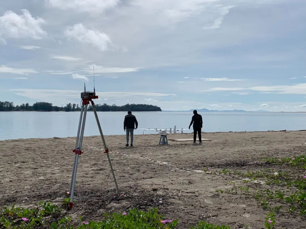
To enhance the city's public safety monitoring and event emergency handling capabilities, the Weinan Municipal Government decided to use the CW-15 VTOL drone combined with the PH-7E multi-rotor to create a 3D model of a 150-square-kilometer area within 30 days. This case study explores the challenges faced during the project and the solutions that were implemented to overcome them.
Challenges
The Weinan Municipal Government faced two main challenges in executing this project. The first challenge was the difficult coordination of airspace. The government had to obtain permission to fly the UAVs in the designated area, which was a complicated process that required coordination with multiple stakeholders, including air traffic control, the police, and the military.
The second challenge was the tight timeline, as the government needed to complete the creation of a 3D model of a 150-square-kilometer area in less than 30 days.
Solutions
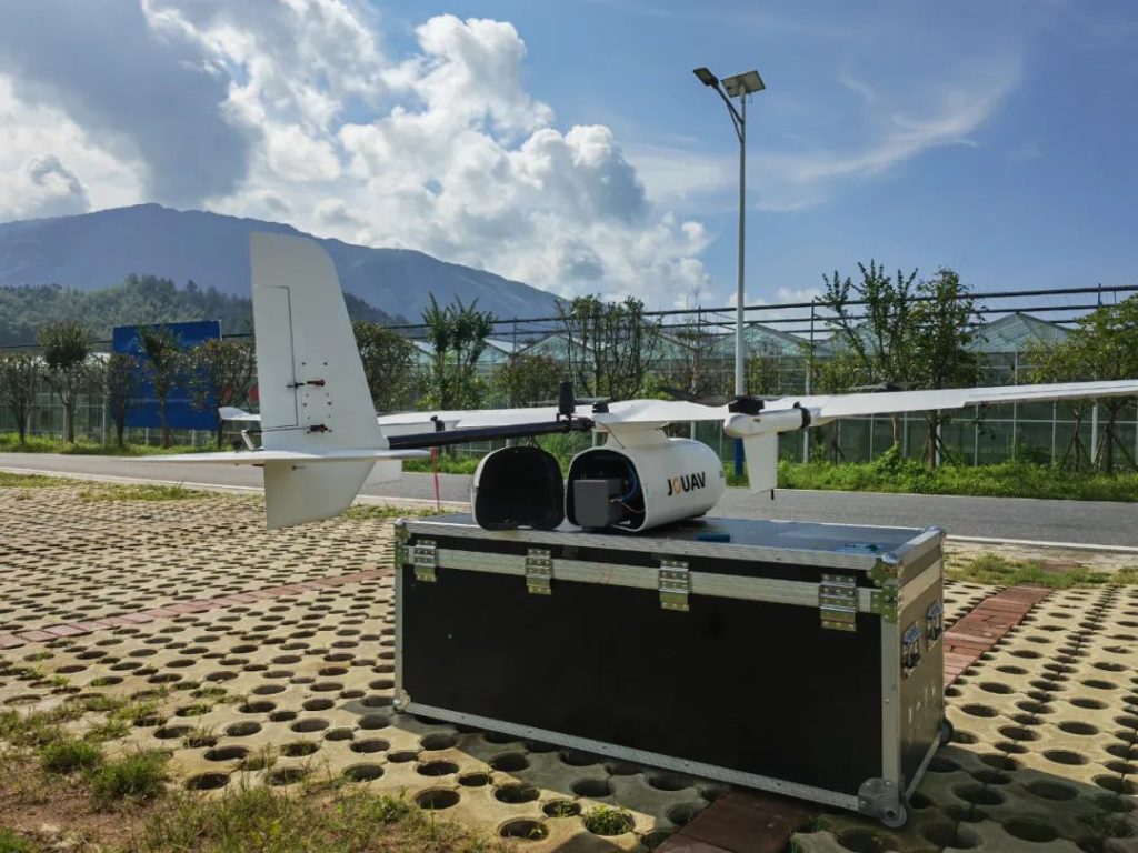
To overcome these challenges, the government utilized the CW-15 VTOL UAV and the PH-7E multi-rotor UAV with the CA-503R oblique camera to capture images from multiple angles.
The CW-15 is a versatile and reliable VTOL drone (Vertical Take-Off and Landing) that can cover large areas quickly and capture high-quality images from high altitudes. With up to 180 minutes of flight time and a control range of up to 50km, the CW-15 is well-suited for large-area mapping and surveillance. It also has fully automated flight capabilities, including one-button take-off and landing, and advanced obstacle avoidance systems that include forward-looking and downward-looking radar, binocular vision obstacle avoidance, and an ADS-B system. These features allow the CW-15 to fly in a variety of challenging weather and terrain conditions, making it an ideal choice for this project.
The PH-7E quadcopter UAV, on the other hand, is designed for more precise and detailed imaging of specific features or structures within the mapped area. With a maximum payload of 3kg and an endurance of up to 63 minutes with payload, the PH-7E can capture highly detailed images and data from a closer distance. It also has a control range of up to 15km and a cruising speed of 23km/h, making it highly maneuverable and flexible in its operations.
To ensure the accuracy and reliability of the 3D modeling process, both drones were equipped with the CA-503R oblique camera, which is considered one of the best quality 5-lens oblique cameras available. With a resolution of 225MP, a full-frame size of 36x24mm, and advanced image processing capabilities, the CA-503R camera can capture high-quality, detailed images from multiple angles and orientations, which is essential for creating a comprehensive and accurate 3D model of the mapped area.
The geotagging process used in this project was also carefully designed to ensure maximum accuracy and efficiency. This process involves using the JOUAV FlightSurv application to extract data from multiple sources, including the images from the CW-503R camera, GNSS data from the CW-15 and PH-7E PPK modules, and basic files (RINEX) from the reference station. By integrating and cross-referencing these different sources of data, the geotagging process is able to generate highly accurate location data for each image, which is essential for creating an accurate and reliable 3D model.
The post-processing was done with the Weinan Municipal government's own post-processing software, which was optimized for maximum efficiency and accuracy using advanced GPU technology and intelligent clustering algorithms.
Results
By utilizing the CW-15 VTOL UAV and the PH-7E multi-rotor UAV, the project team was able to capture high-quality oblique imagery from multiple angles with unprecedented speed and efficiency. This data was then processed into a comprehensive 3D model with a level of accuracy as low as 5cm.
These two drones achieved verification of 3D data under the scene of view height of 150 meters. The elements included in the 3D modeling are comprehensive, and the surface texture of the feature truly reflects the color, texture, shape, and pattern of the feature with coordinated and natural realistic tones, flat planes, straight lines, and clear textures.
"We were blown away by the level of detail and accuracy provided by CW-15 and PH-7E's 3D mapping drones. The ability to capture data from such a high altitude and still have a comprehensive and realistic representation of our site was truly impressive. This technology has completely transformed our approach to urban construction planning and we look forward to utilizing it for future projects", said John Guo, Project Manager from the Weinan Municipal Government.
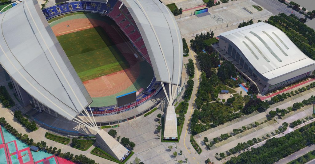
3D model details of the Weinan Gymnasium
The entire 150-square-kilometer area was mapped in just 6 days, which was well within the tight 30-day timeline. “The use of drones enabled our team to quickly and accurately capture data over a large area, which would have been extremely difficult and time-consuming using traditional surveying techniques”, said John.
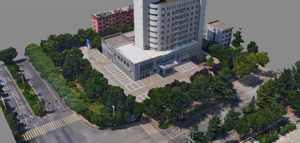
3D model details of the Weinan Management Committee of High-tech New Area
The 3D model created using drone data has played an important role in promoting the urban planning and smart cities of Weinan city. Firstly, the 3D model enables designers to better visualize the layout and design of the entire project to avoid mistakes and unnecessary waste during construction. Secondly, 3D modeling technology helps construction site management and construction monitoring by providing real-time monitoring of the project's progress and quality. Supervisors can identify problems and take appropriate measures to ensure the smooth progress of construction. Thirdly, 3D modeling helps project maintenance and management by creating digital files of existing engineering equipment and infrastructure to enable full lifecycle management of projects. This improves maintenance and management efficiency and provides strong support for the long-term operation of the project.
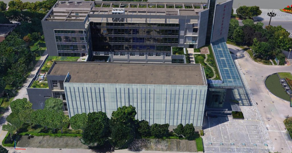
3D model details of the Weinan Intermediate People's Court
Conclusion
Drones have proven to be a valuable tool in urban construction planning and governance. Their ability to capture high-resolution aerial imagery and 3D modeling data can significantly improve decision-making processes and enhance project management efficiency. By utilizing drones, construction companies can save time and resources, while also improving safety on job sites.
However, it is important to address regulatory and privacy concerns and ensure that the use of drones aligns with ethical and legal standards. Overall, the adoption of drone technology has the potential to transform the urban construction industry and drive progress toward more sustainable and resilient cities.
More Use Cases


Chongqing’s Qinba Mountains are basically a giant green wall protecting the region. But there’s a problem – pine wood nematodes are eating through it. Fast.
The forestry department n

When TotalEnergies set out to build one of Southeast Asia’s largest solar and battery storage projects—spanning 12,000 hectares across the dense acacia forests of Riau, Indonesia—they faced a problem

JOUAV Product News and Use Cases
Fixed-Wing VTOL Drones Insights and Industry Trends
Invitations to online demo events