Have you ever watched a drone hover effortlessly over a construction site, inspect a wind turbine blade, or deliver medical supplies to a remote village?
That drone was almost certainly a multirotor.
What is LiDAR?
LiDAR, an acronym for "Light Detection and Ranging," stands as a revolutionary distance-measuring sensor, akin to its counterparts radar and sonar. Functioning by emitting laser pulses that rebound off objects, LiDAR sensors meticulously capture the intricate structure of their surroundings. The process involves recording the energy of the reflected light, enabling the precise determination of distances to objects. This, in turn, facilitates the creation of detailed 2D or 3D representations of the environment.
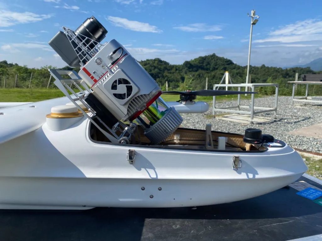
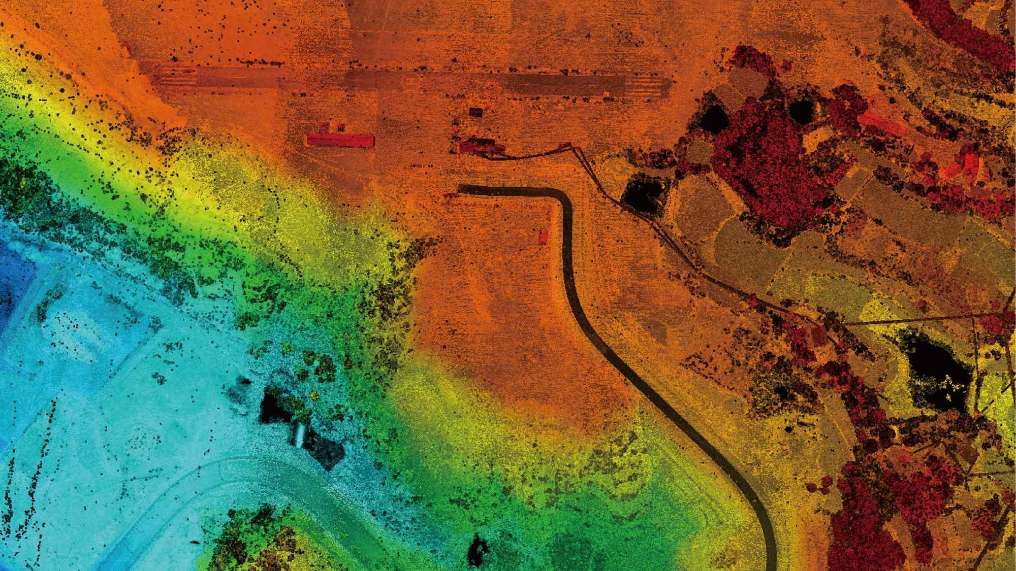
The JOUAV CW-25E VTOL drone with JoLiDAR-LR22S LiDAR sensor
LiDAR's superiority in sensing accuracy, compared to traditional technologies like radar and sonar, stems from its laser precision. It crafts detailed point clouds, essentially translating the features of objects or environments into tangible, solid representations on displays.
Operating across various wavelengths, from infrared (10 micrometers) to ultraviolet (250 nanometers), LiDAR employs different types of scattering (Rayleigh, Raman, Mie) tailored for specific applications. The ability to identify wavelength-dependent changes in the scattering signal extends its utility to the remote mapping of atmospheric composition and object properties.
The versatility of LiDAR extends across multiple platforms, from being mounted on aircraft such as airplanes, helicopters, or drones, to satellites, automobiles, and ground-based or hand-held devices. Remarkably, LiDAR has become so accessible that it's now found in everyday devices, including cell phones.

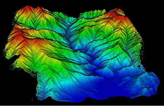
Topographic LiDAR
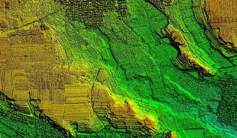
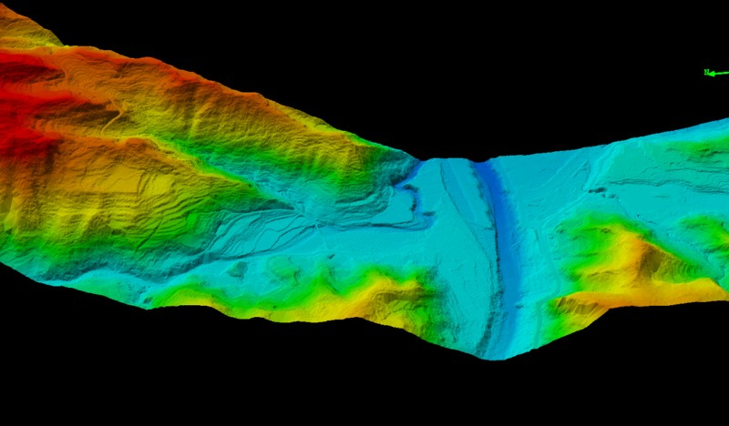
Topographic LiDAR, employing a 1,064 nm near-infrared laser, is extensively used for land-based mapping. This system captures a dense point cloud, enabling the creation of high-precision 3D maps and models of the Earth's surface. To enhance accuracy, UAV topographic LiDAR often integrates a GPS receiver and an inertial navigation system (INS). Post-processing of data further refines precision.
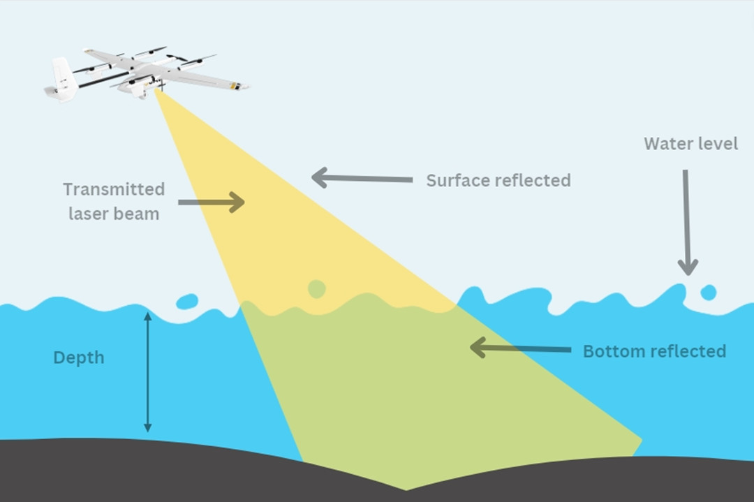
Bathymetric LiDAR
Bathymetric LiDAR systems, utilizing a green wavelength of 532nm, are specifically designed to measure seafloor depths and shoreline elevations. These systems provide valuable information near coastlines, harbors, and shores. The dual functionality involves collecting elevation and water depth simultaneously, utilizing both infrared and green lasers for comprehensive airborne surveys.
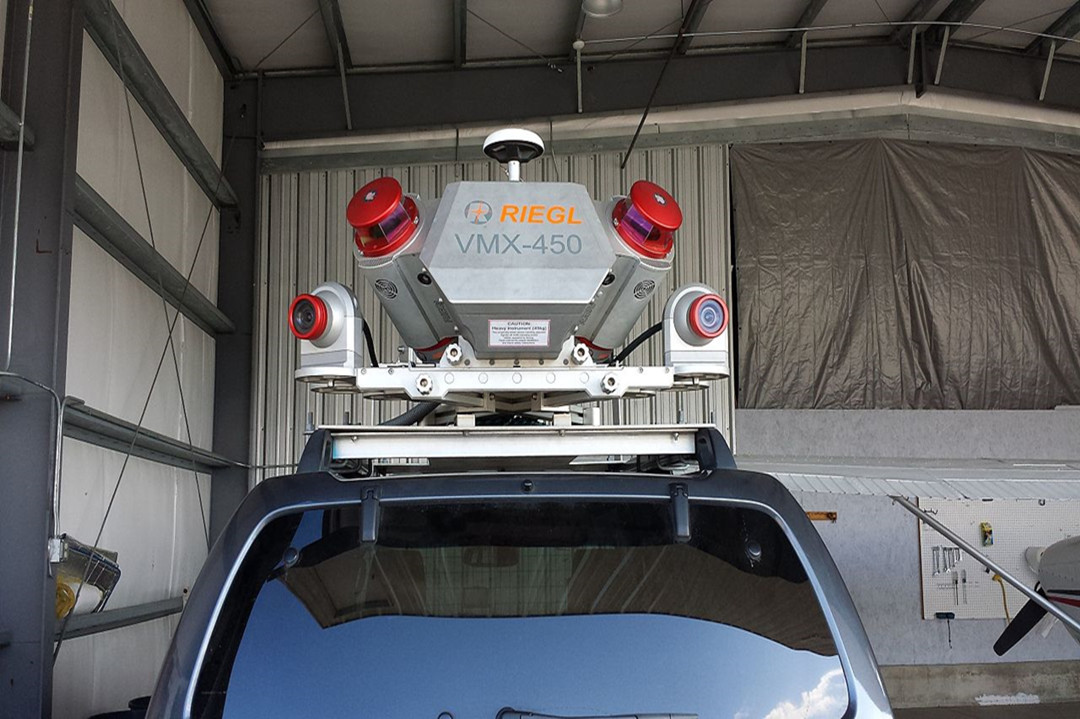
Mobile LiDAR
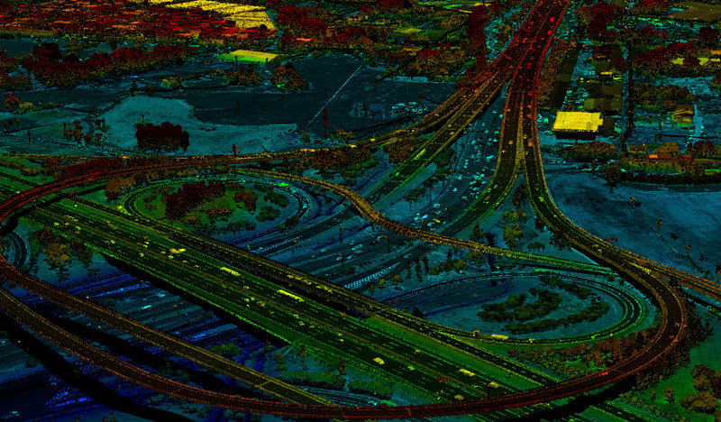
Dynamically mounted on moving platforms such as vehicles, trains, or boats, Mobile LiDAR systems play a crucial role in analyzing road infrastructure, identifying obstacles, and surveying transportation corridors. These systems often integrate LiDAR sensors with cameras, GPS, and inertial navigation systems for comprehensive data collection.
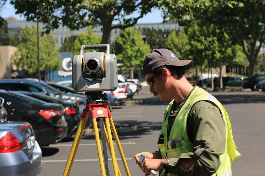
Static LiDAR
Positioned on tripods, Static LiDAR systems bring portability and flexibility to detailed scanning, accommodating both indoor and outdoor environments. Their applications span various industries, including engineering projects, mining operations, land surveying, and archaeological excavations.
2D LiDAR
2D LiDAR operates by emitting laser pulses in a single plane, typically horizontal or vertical. The sensor gauges the time it takes for the laser pulses to return, offering distance information within that specific plane. This design comprises an emitter laser diode and a receiver photodiode, with each color representing a distinct "layer." For instance, a 64-layer LiDAR sends 64 lines of photons. This type of LiDAR finds utility in applications where a flat representation of the environment suffices, such as in industrial automation for basic obstacle detection, inventory management, and fundamental mapping tasks.
3D LiDAR
3D LiDAR captures spatial information in multiple planes (X, Y, Z), generating a detailed three-dimensional point cloud. This is achieved either by employing multiple lasers or a scanning mechanism that steers the laser beam in both horizontal and vertical directions. Ideal for applications demanding a thorough understanding of the three-dimensional structure of the environment, 3D LiDAR is commonly used in autonomous vehicles for obstacle avoidance, mapping, navigation, as well as in urban planning, forestry, and archaeology.
4D LiDAR
4D LiDAR goes beyond the static nature of 3D LiDAR by adding the dimension of time. This enhancement enables the sensor to capture changes and movements in the environment over time. Suited for dynamic environments where tracking moving objects or monitoring changes is crucial, 4D LiDAR finds applications in traffic management, security surveillance, and monitoring the flow of crowds in public spaces. It enhances situational awareness by not only providing a detailed 3D map but also allowing for the tracking of changes over time. This capability enables predictive analysis and monitoring of temporal dynamics.
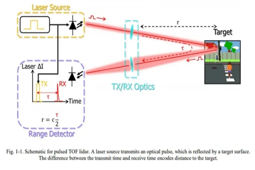
Time-of-Flight (ToF) LiDAR
ToF LiDAR operates based on the principle of measuring the time it takes for a laser pulse to travel to a target and back. This system emits short pulses of laser light and measures the time delay for the reflected light to return. The distance to the object is then calculated using the speed of light. One advantage of ToF LiDAR is its ability to provide accurate distance measurements with high resolution. However, it may face challenges in accurately measuring longer distances and suffers from potential interference issues.
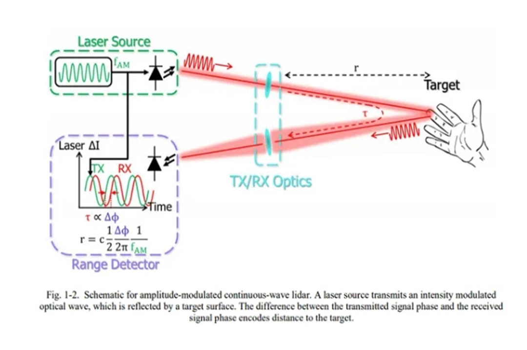
Amplitude Modulated Continuous Wave (AMCW) LiDAR
AMCW LiDAR, on the other hand, utilizes a continuous laser beam with its amplitude modulated at a known frequency. By analyzing the phase shift between the emitted and received signals, the system determines the distance to the target. AMCW LiDAR is known for its capability to measure both distance and velocity accurately. Its advantages include the ability to handle various environmental conditions, but it may have limitations in terms of resolution and susceptibility to interference.
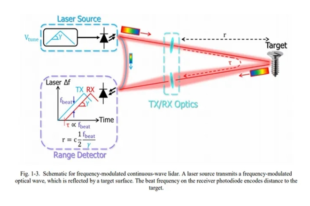
Frequency Modulated Continuous Wave (FMCW) LiDAR
FMCW LiDAR, in contrast, employs a continuous laser beam that is frequency modulated. The distance is calculated by analyzing the frequency difference between the emitted and received signals. FMCW LiDAR offers advantages such as high accuracy and the ability to measure multiple targets simultaneously. However, it may face challenges in terms of complexity and cost.
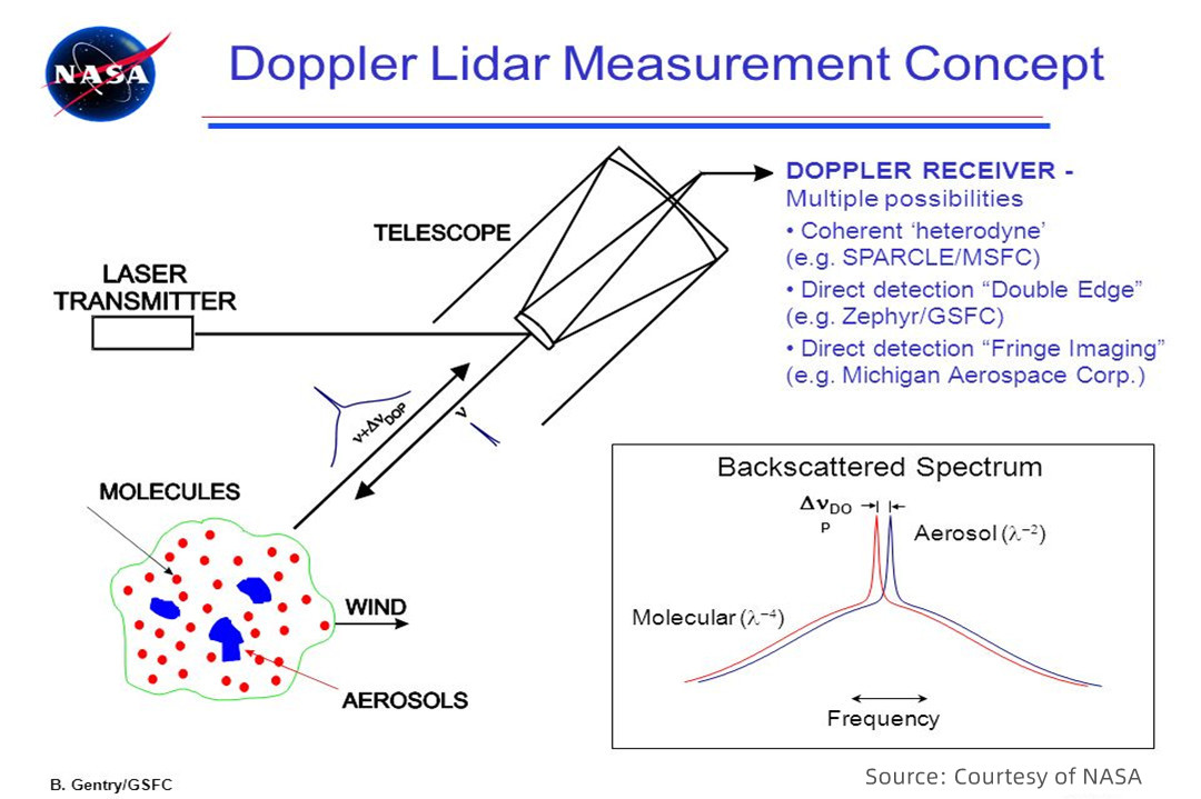
Doppler LiDAR
Doppler LiDAR assesses the velocity of a target by examining the frequency shift of laser light scattered by moving particles in the atmosphere, leveraging the Doppler effect. This frequency change occurs when the target is in motion. Doppler LiDAR is commonly used for measuring wind speed and direction in applications such as atmospheric research and wind resource assessment for wind energy. Its capability to provide velocity information makes it valuable in understanding dynamic atmospheric conditions.
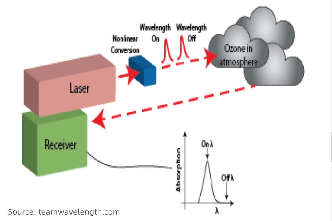
Differential Absorption LiDAR (DIAL)
Differential Absorption LiDAR (DIAL), a specialized Lidar variant, focuses on measuring atmospheric gas concentrations. It utilizes two laser wavelengths - one absorbed by the target gas and another not. By comparing backscattered signals from both wavelengths, DIAL determines the concentration of the specific gas being targeted. This makes DIAL LiDAR crucial for remote sensing of atmospheric composition, commonly employed in monitoring air quality by measuring pollutant concentrations.
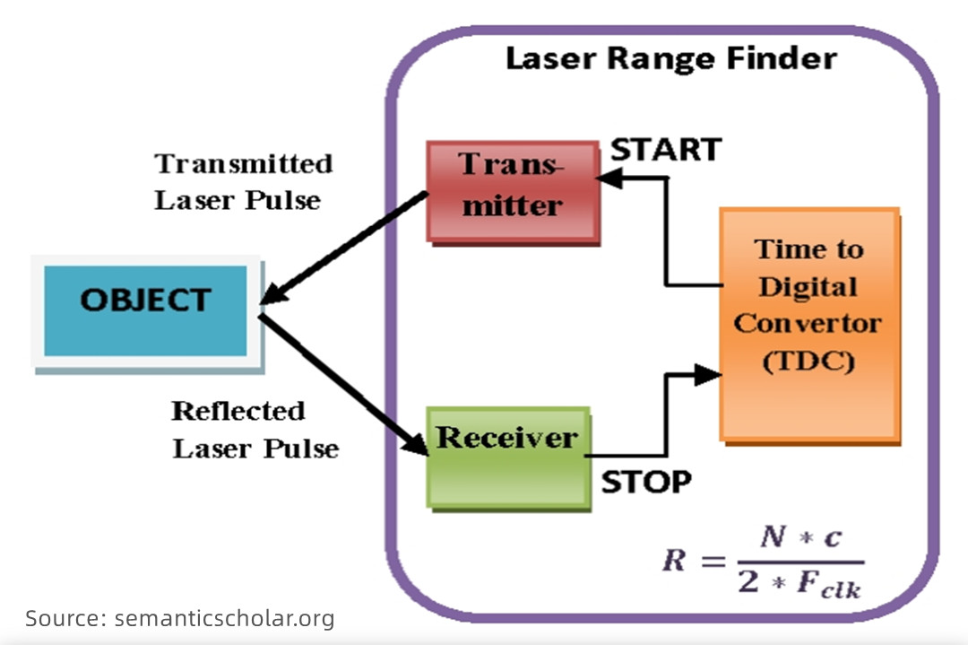
Range Finder
Range Finder LiDAR calculates distances by measuring the time it takes for a laser pulse to travel to a target and back. The distance is determined by multiplying the speed of light by the round-trip time. This type of LiDAR is commonly employed in topographic mapping, forestry, and autonomous vehicles due to its accuracy in distance measurement.
How Does LiDAR Work?
LiDAR, whether deployed on aircraft, drones, or handheld devices, operates on a fascinating principle: shooting a potent laser beam at a target and meticulously measuring its rebound. Think of it as akin to radar and sonar but with light instead of radio or sound waves.
At its core, a LiDAR system consists of three key components: the laser, the scanner, and the Global Positioning System (GPS).
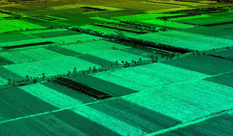
Source: yellowscan.com
1. The Laser
LiDAR systems can employ different types of laser sources, each tailored to specific applications. Continuous wave (CW) sources emit a continuous stream of light, which is commonly used in LiDAR systems for measuring velocity or chemical constituents.
On the other hand, pulsed and chirped sources emit short bursts or pulses of laser light which are particularly useful for precise range measurements in LiDAR systems.
2. The Scanner
Directed by rotating or oscillating mirrors, the laser pulses systematically cover a wide area, scanning the Earth's surface. As these pulses encounter objects, they bounce back toward the LiDAR sensor, creating a comprehensive dataset.
3. Global Positioning System (GPS)
The integration of GPS receivers is paramount for precision. By providing accurate x, y (horizontal), and z (altitude) positions of the LiDAR sensor, GPS ensures the creation of meticulous 3D maps.
The magic of LiDAR unfolds with the laser pulses. Emitting pulses of invisible light, LiDAR maps surfaces by measuring the time it takes for these pulses to return. The formula at play is simple yet powerful:
d = c * t / 2
In the formula, each letter represents:
- d is the distance
- c is the speed of light
- t is the time of the flight
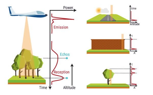
LiDAR doesn't just interact with one surface; a single pulse may encounter multiple surfaces, creating what's known as "first return" (often the topmost object) and subsequent returns, revealing features beneath the initial layer.
To cover extensive areas, LiDAR systems employ scanning mechanisms involving rotating mirrors or similar devices. Meanwhile, precise location data is ensured by integrating multiple GPS or GNSS satellites and receivers, and often, inertial navigation system instruments in aircraft correct for movements induced by air currents.
The culmination of these measurements manifests as a point cloud - a rich 3D representation of the surveyed area. Through meticulous processing and analysis, this data becomes a valuable resource for diverse applications, from urban planning to forestry and the navigation of autonomous vehicles. LiDAR, with its laser precision and technological finesse, paints a vivid picture of our surroundings in three dimensions.
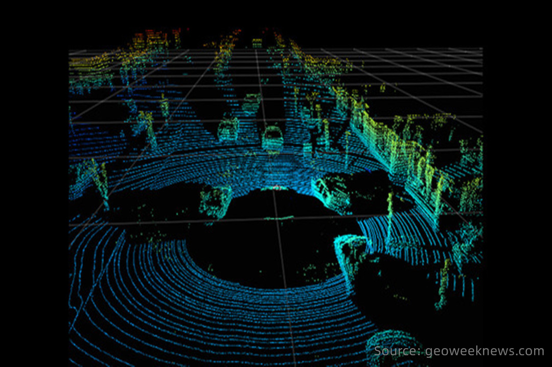
Navigation
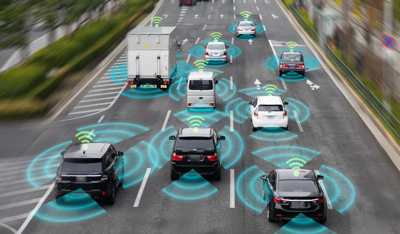
LiDAR, with its laser precision, essentially paints a dynamic picture of the world around an autonomous vehicle. As the car cruises, LiDAR continuously sends out laser beams, creating a detailed 3D map – a sort of digital twin of the real world. This real-time mapping is like a guiding hand, helping the car to precisely position itself and navigate through the maze of the urban or suburban landscape.
Think of it as a constantly evolving GPS but on a much more detailed level. It's not just about knowing where the car is; it's about understanding the surroundings down to the centimeter, allowing the vehicle to make split-second decisions based on the most up-to-date information about its environment.
Collision Avoidance
LiDAR is the watchful eye that spots potential collisions before they happen. Picture this: as the car moves, LiDAR beams go out, bouncing off objects and returning with information about what's ahead. If there's a sudden obstacle, like a pedestrian crossing the street or a car making an unexpected turn, LiDAR detects it in real time.
What makes it truly remarkable is its ability to not just see obstacles but to help the car intelligently respond. If there's a potential collision, the autonomous system can swiftly recalculate the route, making split-second decisions to steer clear of danger. It's like having a co-pilot with superhuman reflexes, always ready to hit the brakes or swerve to keep everyone safe.
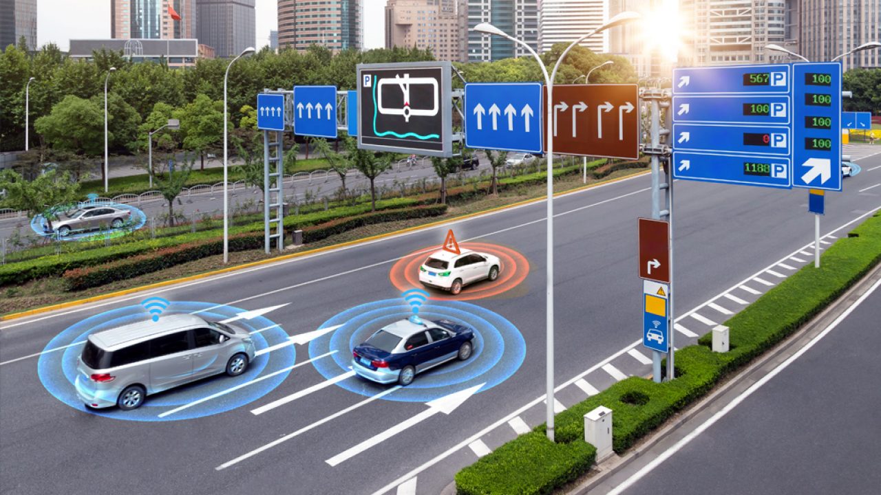
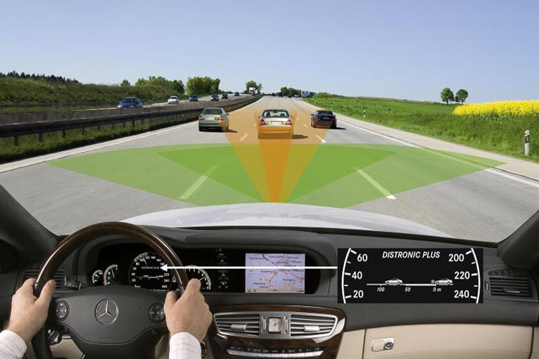
Autonomous Cruise Control (ACC)
Ever been annoyed by a car tailgating you or wished the car in front would speed up? LiDAR is the technology turning that wish into reality. In autonomous cruise control systems, LiDAR is the vigilant sensor on the lookout for the vehicle's surroundings. It's not just maintaining a set speed; it's maintaining a safe distance from the car in front.
By constantly measuring the distance and relative speed between your car and the one ahead, LiDAR enables the vehicle to be a smart and considerate driver. It's not just about cruising on autopilot; it's about doing it in a way that respects the flow of traffic and keeps everyone at a safe distance.
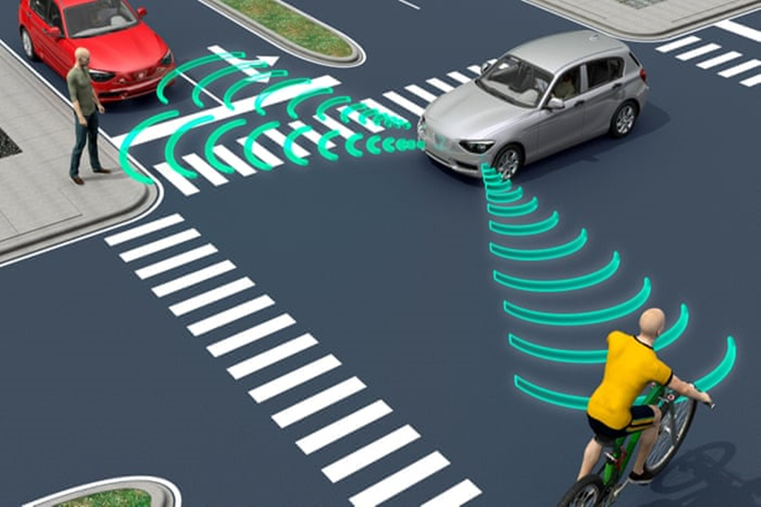
Obstacle Detection
LiDAR turns an autonomous vehicle into a keen observer of its environment. Imagine LiDAR as the eyes of the car, able to see in all directions simultaneously. It doesn't just see objects; it sees them with incredible accuracy, down to the centimeter.
This 360-degree visibility is a game-changer. It means the car not only spots stationary obstacles like lampposts or parked cars but also detects dynamic ones – the pedestrian stepping off the curb or the cyclist coming from the side. And here's the kicker – it does this in all weather conditions. Rain, fog, or sunshine, LiDAR remains a reliable set of eyes, ensuring the car is always aware of what's happening around it.
Bridge Inspections
Consider bridge inspections, where LiDAR-equipped drones swiftly and precisely evaluate conditions. They identify potential problems such as corrosion or structural deformations, enabling engineers to prioritize maintenance effectively and enhance overall safety.
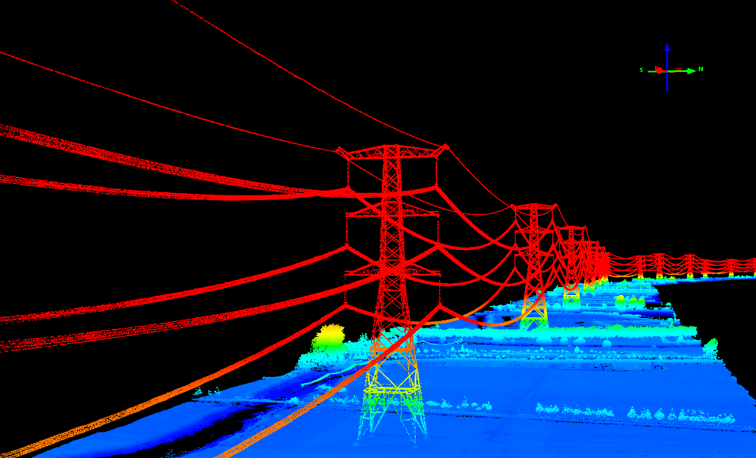
Power Line and Utility Inspections
Power line and utility inspections benefit from LiDAR's detailed data. Drones equipped with LiDAR identify hazards like vegetation encroachment or damaged equipment, allowing for preventive maintenance and ensuring the reliability of energy infrastructure.
Dam and Levee Monitoring
For dam and levee monitoring, LiDAR aids in assessing stability and integrity. By identifying potential issues early on, engineers can take timely steps to address concerns, ensuring the ongoing safety of critical water management systems.
Railway and Transportation Systems
Railway and transportation systems also leverage LiDAR. Drones inspect tracks, tunnels, and infrastructure, detecting issues such as deformations or obstructions. This proactive approach minimizes disruptions and maintains the safety and efficiency of transportation systems.
Soil Insight and Analysis
Utilizing geospatial data from LiDAR for digital soil mapping enhances soil insight. It delves into topsoil quality, soil classification, and drainage efficiency. This knowledge is vital for optimizing irrigation strategies and avoiding waterlogging in specific areas.
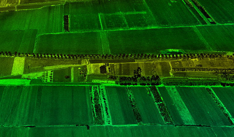
Improving Irrigation
Efficient irrigation planning becomes possible by identifying water sources and mapping out water distribution. LiDAR aids in steering clear of sections prone to water pooling or where soils retain moisture more effectively, ensuring judicious use of water resources.
Minimizing Erosion
Understanding the slope of your land enables erosion minimization. Even minor shifts in elevation, when detected in advance, allow for proactive measures to prevent soil erosion, safeguarding valuable topsoil and sustaining crop health.
Planning Crop Planting
In large-scale farming, variations in sun exposure, water drainage, and erosion necessitate meticulous planning. LiDAR-derived insights empower farmers to strategically plan crop planting, optimize output and minimize losses based on the diverse conditions across the farm.
Forecasting Crop Yields and Output
LiDAR data proves invaluable in forecasting crop yields and monitoring crop conditions throughout the growing season. This analytical advantage enables farmers to predict yields more accurately, facilitating informed decisions to maximize agricultural income.
Determining Crop Damage
In the event of severe weather events or other issues affecting crops, LiDAR provides an accurate assessment of damage severity. Unlike traditional monitoring methods, LiDAR offers a detailed and comprehensive view of the impact, aiding farmers in assessing losses and planning recovery strategies effectively.
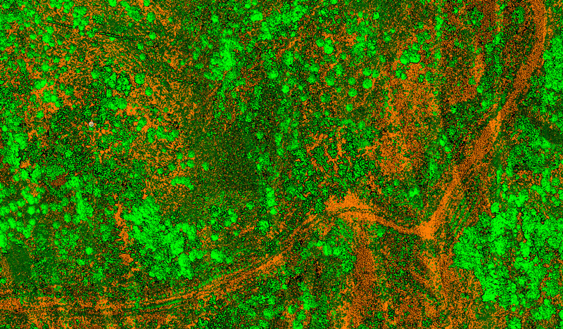
Controlling Deforestation
Aerial LiDAR swiftly evaluates the extent of deforestation by assessing the volume of felled trees. It enables specialists to compare actual volumes with predicted ones, facilitating the identification of inconsistencies and aiding in efforts to control deforestation.
Forest Planning and Management
Utilizing LiDAR drones facilitates powerline scanning to detect potential clashes with tree canopies. It contributes to overall forest planning by mapping digital elevation, assisting in topography assessments, and documenting intricate forest environments.
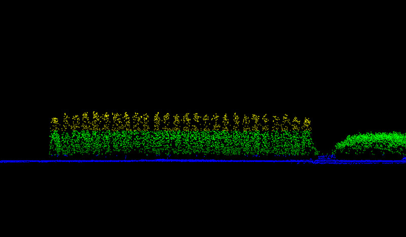
Identifying Tree Stem Attributes
LiDAR captures detailed data, and specialized algorithms are employed to detect individual trees and identify their positions. These algorithms segment trees, enabling efficient tree counts over large areas, a valuable tool for effective forest management.
Measuring Carbon Absorption
LiDAR data analysis is instrumental in determining carbon absorption rates. By examining individual stand attributes, such as tree or crown diameter, scientists gain insights into the carbon absorption properties of the forest, contributing to ecological understanding and carbon accounting.
Wildlife Conservation
Post-processing analysis of LiDAR data provides valuable measurements, including biomass and densitometric data, supporting assessments of forest suitability for specific wildlife species. This aids in strategic forest planning and conservation efforts, ensuring ecosystems are conducive to various forms of wildlife.
Forest Fire Management
In the context of climate change mitigation, LiDAR technology is employed to predict and monitor forest fire risks. LiDAR data identifies wood debris on the ground, serving as potential fire tinder. This information is crucial for tracking wildfire patterns and understanding historical fire paths, aiding in effective forest fire management strategies.
Robotics
LiDAR technology is a game-changer for robotics, bringing precision and adaptability to various crucial functions:
Navigation
Navigational prowess is heightened as LiDAR sensors furnish real-time insights into the robot's surroundings. Through emitting laser beams, LiDAR crafts a dynamic 3D map, empowering robots to chart their course autonomously.
Obstacle Avoidance
Obstacle avoidance becomes seamless with LiDAR, enabling robots to swiftly detect and sidestep barriers like walls and doors. This real-time obstacle detection is pivotal for ensuring safe and efficient robot movement in ever-changing environments.
Localization
Accurate localization is a forte of LiDAR. By cross-referencing real-time sensor data with existing maps, robots pinpoint their exact location with precision, elevating the reliability of their navigation.
Mapping
Mapping capabilities reach new heights as LiDAR's laser beams meticulously measure distances in three dimensions. This detailed mapping equips robots with a comprehensive understanding of their environment, aiding decision-making processes.
Perception
Perception takes center stage as LiDAR sensors provide intricate details about the surroundings. Robots leverage this information to discern objects and people, enabling them to make nuanced decisions and adapt to diverse scenarios.
Real-time Environment Monitoring
The real-time monitoring prowess of LiDAR is indispensable. Continuously observing the environment, LiDAR sensors offer crucial data about dynamic changes, ensuring that robots can flexibly adapt to evolving conditions and navigate with confidence.
Climate Monitoring
LiDAR technology is a linchpin in climate monitoring, seamlessly integrating into various facets of environmental research:
Carbon Sequestration
LiDAR's laser beams penetrate forest canopies, measuring the vertical structure of vegetation. This information assists in estimating biomass and assessing forest health. Researchers can use these measurements to understand carbon sequestration capacity, helping in the development of effective strategies for carbon management and climate change mitigation.
Glacier Monitoring
LiDAR plays a crucial role in monitoring changes in glacier volume and extent. By comparing successive LiDAR scans over time, scientists can precisely measure glacial retreat or advancement, contributing valuable data for understanding the impact of climate change on glacial systems and predicting potential sea-level rise.

Coastal Zone Management
LiDAR assists in studying coastal dynamics by monitoring shoreline changes and erosion. This information is essential for coastal zone management and understanding the vulnerability of coastal areas to rising sea levels and extreme weather events.
Air Quality Monitoring
LiDAR, when integrated with other sensors, provides high-resolution data for monitoring air quality. It can detect and quantify pollutants such as particulate matter, ozone, and gases. This information contributes to assessing the impact of air pollution on climate and human health, supporting the development of effective pollution control measures.
Site Discovery and Mapping
LiDAR captures high-resolution data that allows archaeologists to identify subtle features on the landscape, such as ancient roads, walls, and foundations. The precision of LiDAR aids in mapping extensive areas efficiently, revealing potential archaeological sites that might be missed through traditional survey methods.
Topographic Modeling
LiDAR creates accurate topographic models, offering a detailed representation of the land surface. This is particularly valuable for studying archaeological sites in varying terrains, enabling researchers to analyze elevation changes and understand how ancient communities interacted with their surroundings.
Identification of Anthropogenic Features
LiDAR aids in the identification of anthropogenic features such as earthworks, mounds, and terraces. By detecting subtle changes in elevation, archaeologists can pinpoint these features, contributing to a more comprehensive understanding of past human activities.
Landscape Analysis
LiDAR facilitates the analysis of settlement patterns by providing a broader view of the landscape. Researchers can study the layout of ancient civilizations, including the distribution of settlements, agricultural areas, and resource usage, contributing to a holistic understanding of past societies.
Cultural Resource Management
LiDAR assists in cultural resource management by providing critical information for assessing the impact of development projects on archaeological sites. This proactive planning ensures the preservation of cultural heritage amid urbanization and infrastructure development.
Vegetation Penetration
In areas covered by dense vegetation, LiDAR's ability to penetrate through the canopy unveils archaeological features that might be hidden. This is especially useful in tropical forests, where vegetation can make ground-based surveys challenging.
Police and Law Enforcement
Police use LiDAR technology primarily for traffic enforcement and speed detection. Here's how police use LiDAR devices:
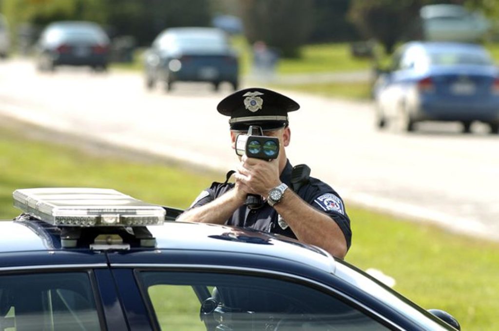
Speed Detection
Police use a LiDAR (laser) gun to measure a vehicle's speed. LIDAR uses a short burst of infrared laser light to reflect off a vehicle and back to the gun. By analyzing the time it takes for the laser beam to travel to the vehicle and back, the LIDAR gun can calculate the speed of the vehicle with high precision.
Distance Measurement
LiDAR technology is employed to measure the distance between vehicles, aiding in enforcing regulations related to safe following distances. This is particularly important for preventing accidents caused by tailgating.
Traffic Flow Analysis
LiDAR devices can be strategically positioned to monitor traffic flow on roads and highways. The data collected helps law enforcement agencies understand traffic patterns, identify congestion points, and optimize traffic management strategies for improved safety and efficiency.
Accident Reconstruction
In the aftermath of a traffic accident, LiDAR technology is used for forensic analysis and accident reconstruction. LiDAR captures detailed information about the accident scene, including the positions of vehicles, road conditions, and other environmental factors. This aids in determining the sequence of events leading to the accident.
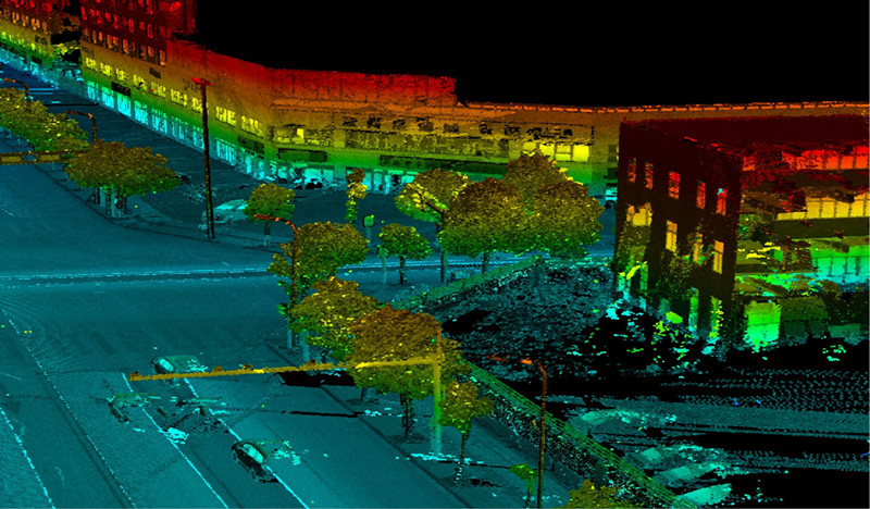
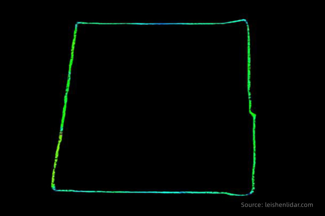
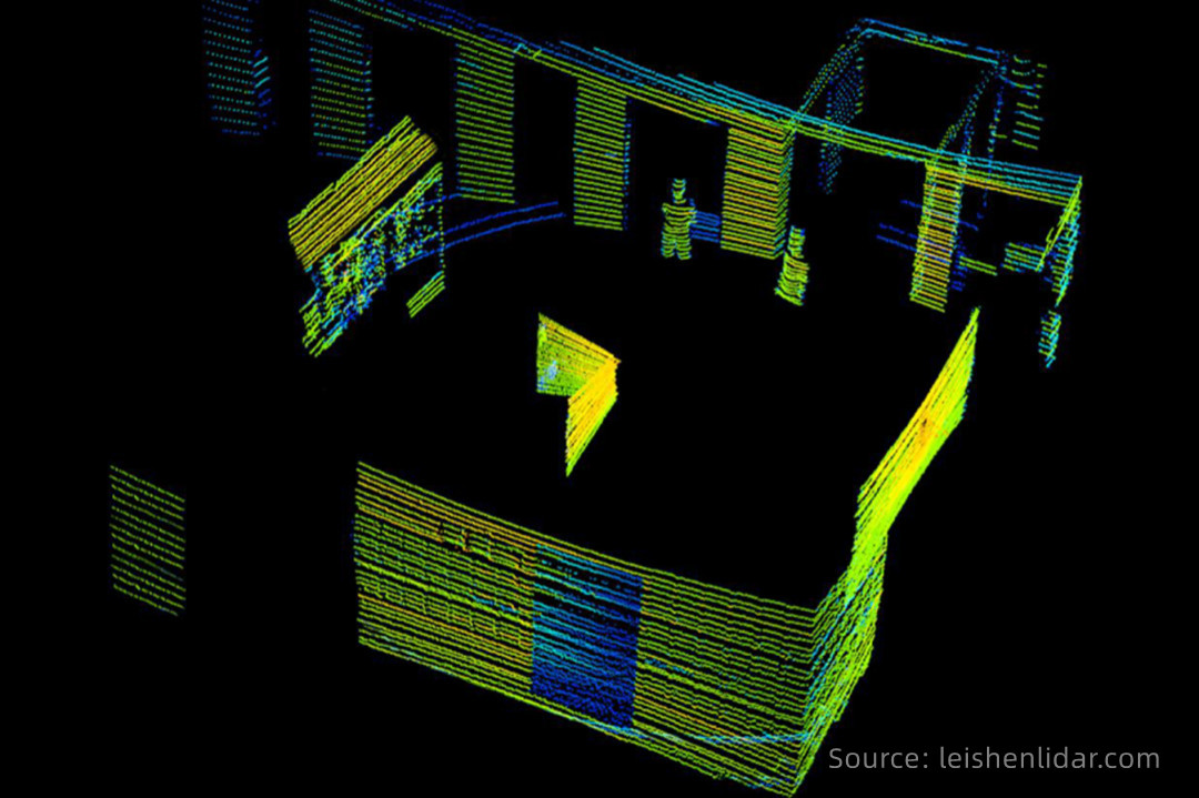
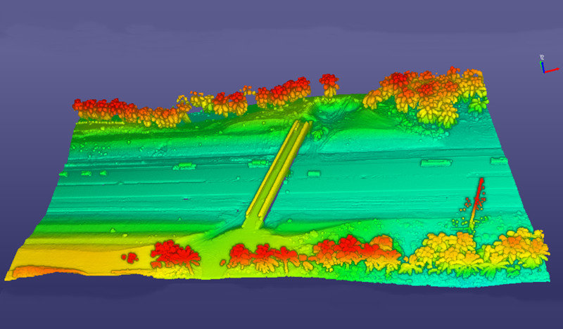
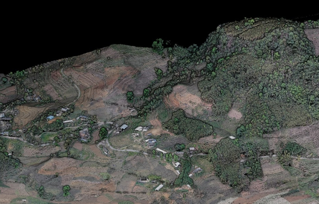
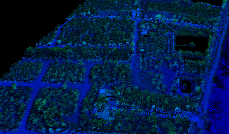
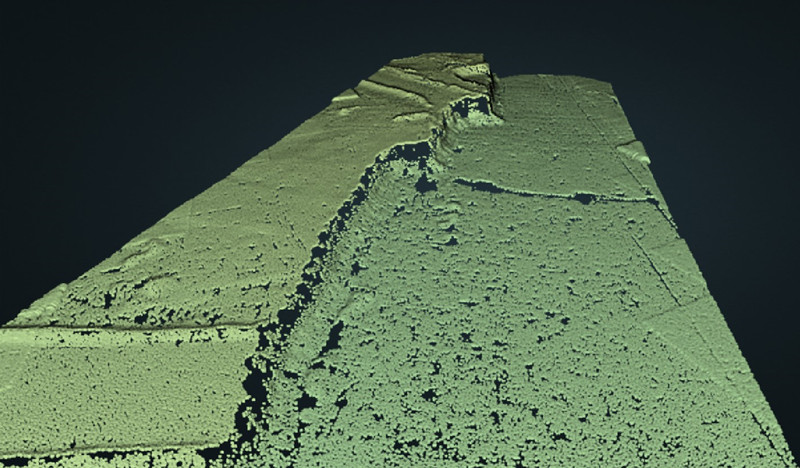
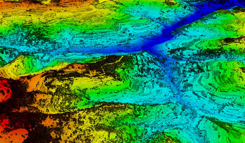
What is LiDAR Mapping?
LiDAR mapping employs a laser scanning system equipped with an Inertial Measurement Unit (IMU) and a Global Navigation Satellite System (GNSS) receiver. The simultaneous use of the Simultaneous Localization and Mapping (SLAM) algorithm and Real-Time Kinematic (RTK) technology ensures precise georeferencing of each measurement point in the resulting point cloud.
LiDAR's laser beams create a 3D representation of the target object or area. Each point in the point cloud corresponds to a precise location, allowing for an accurate and detailed spatial model.
LiDAR maps provide both absolute and relative positional accuracy. This means that not only can the viewer determine the geographical location of the data collected, but they can also understand the spatial relationships between points in terms of distance. This dual accuracy is crucial for various applications, from infrastructure planning to environmental monitoring.
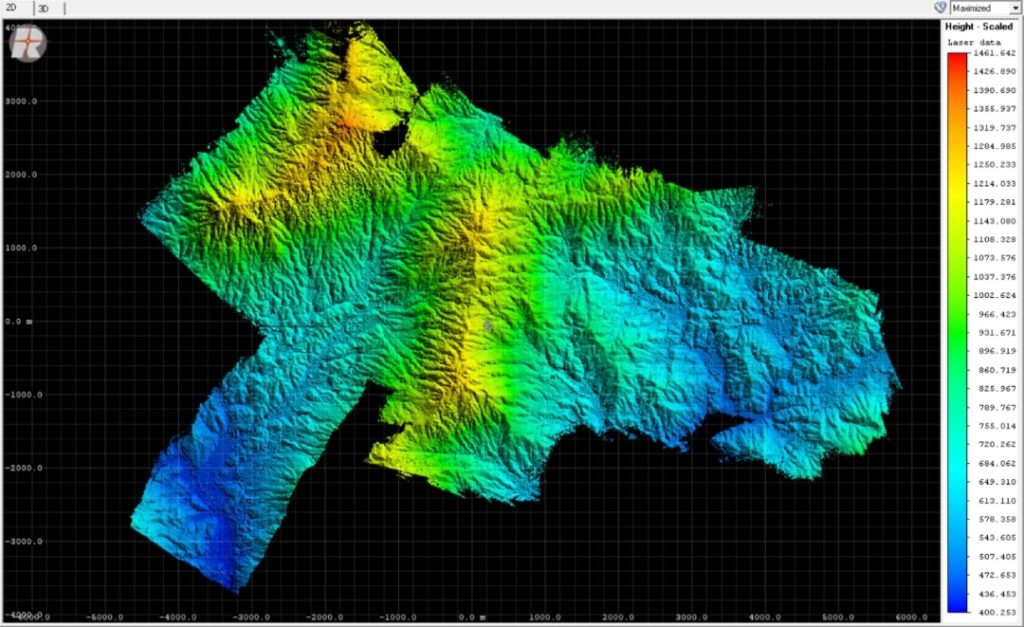
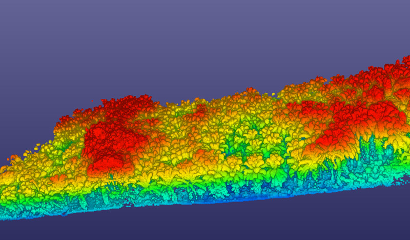
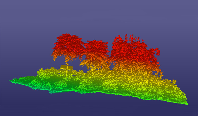
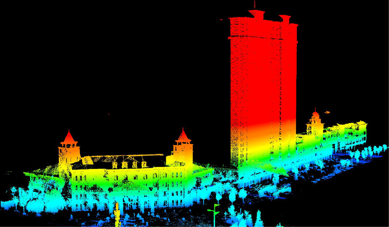
What is LiDAR Accuracy?
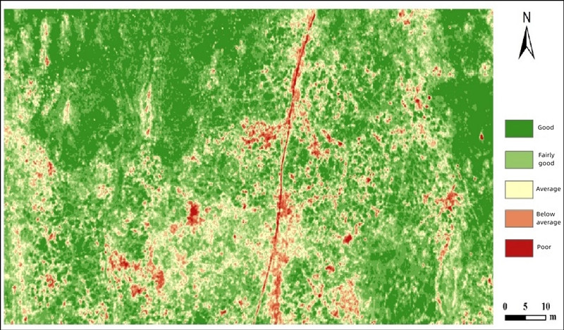
LiDAR accuracy, essentially how closely the collected data aligns with the real-world values, is crucial for its various applications. We often gauge accuracy by calculating the Root Mean Square Error (RMSE), which gives us a measure of the discrepancies between the LiDAR data and the ground truth.
Typically, LiDAR sensors are pretty impressive – they can be accurate within 0.5 to 10mm compared to the sensor itself. When it comes to mapping, they can nail it with up to 1cm accuracy in horizontal (x, y) and 2cm in vertical (z). So, basically, they're really good at capturing details with a high level of precision!
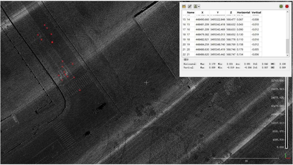
The JOUAV CW-25E VTOL drone equipped with JoLiDAR-1500 acquired vertical accuracy as low as 0.6cm and horizontal accuracy as low as 0.5cm at an altitude of 310m.
There are two main types of LiDAR accuracy: absolute and relative.
Absolute Accuracy
Absolute accuracy involves both horizontal and vertical dimensions. Horizontal accuracy is determined by comparing LiDAR data with ground-surveyed checkpoints, which are well-defined points on the ground with accurately surveyed horizontal positions. Vertical accuracy, on the other hand, is assessed by comparing LiDAR data with surveyed points on flat and open terrain, minimizing interpolation errors. Fundamental vertical accuracy, achieved in such terrain, serves as a benchmark for assessing LiDAR dataset vertical accuracy. The distribution of checkpoints is contingent on land cover type and terrain, with guidelines provided by standards like the ASPRS 2014 Standard.
Relative Accuracy
Relative accuracy focuses on the internal quality of LiDAR elevation data without relying on surveyed ground control points. It assesses local differences between points in the point cloud and is influenced by LiDAR system calibration. This calibration is essential for ensuring stability both within the same swath (within-swath accuracy assessment) and between swaths or flight lines (swath-to-swath accuracy assessment).
Factors Affecting LiDAR Accuracy:
Sensor Calibration
LiDAR sensors must undergo meticulous calibration processes to ensure accurate measurements. Calibration involves aligning and adjusting various components of the sensor, such as the laser transmitter, receiver, and internal timekeeping systems. Any misalignment or error in calibration can lead to inaccuracies in the captured data.
Georeferencing (GPS and IMU Data)
Global Positioning System (GPS) data is crucial for determining the precise location of LiDAR measurements. Accurate georeferencing relies on high-quality GPS data to correctly place each point in three-dimensional space.
Inertial Measurement Units (IMUs) help account for the sensor's orientation and motion. Any errors or drift in IMU data can result in inaccuracies in the LiDAR point cloud.
Environmental Conditions
Adverse weather conditions, such as rain, fog, or snow, can scatter laser beams and interfere with the accurate detection of objects. Some LiDAR systems may incorporate algorithms to compensate for such environmental factors, but extreme conditions can still pose challenges.
Data Processing and Filtering
Proper data processing techniques, including filtering and noise reduction algorithms, are vital for cleaning and refining raw LiDAR data. Inaccuracies can be introduced during the processing stage if not handled appropriately.
While high resolution is valuable, it should not compromise accuracy. Striking the right balance is essential to ensure that the detailed information provided by high-resolution data is also trustworthy and aligns with the true characteristics of the surveyed area.
The ideal balance between resolution and accuracy depends on the specific requirements of the project. For applications where precise details are critical, a higher resolution might be prioritized. However, for tasks where overall accuracy is paramount, a balance that leans towards accuracy may be preferred.
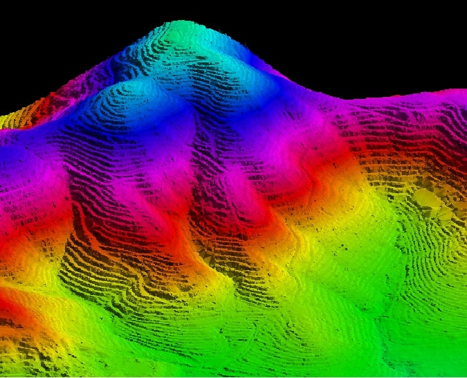
What is a DTM in LiDAR?
A Digital Terrain Model (DTM) in LiDAR applications meticulously represents the Earth's ground surface by meticulously excluding objects such as buildings and vegetation. This specialized model concentrates solely on the intrinsic topography, affording a nuanced understanding of the natural terrain. It proves invaluable in hydrological modeling, where precise delineation of ground features is pivotal for accurate water flow simulations, and in geological studies where unadulterated landform analysis is essential.
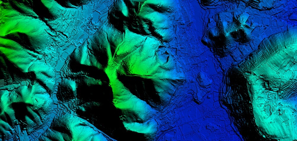
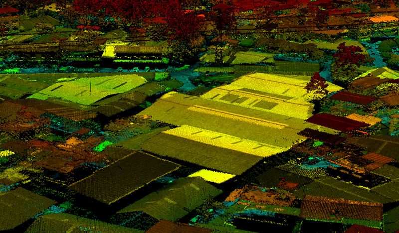
What is a DSM in LiDAR?
A Digital Surface Model (DSM) in the LiDAR context encapsulates the entirety of the Earth's surface, seamlessly integrating both the ground and above-ground elements. This model yields a holistic representation, offering rich visual detail encompassing features like buildings, trees, and other structures. DSMs find applicability in urban planning endeavors, facilitating the modeling of cityscapes, assessing building heights, and aiding in infrastructure development planning. Additionally, in forestry applications, DSMs prove instrumental for gauging canopy structures, tree heights, and overall vegetation density.
What is DEM in LiDAR?
The overarching term Digital Elevation Model (DEM) serves as a comprehensive framework that encompasses both DTMs and DSMs. Its adaptability allows it to be tailored to specific requirements, serving as a foundational dataset for various applications. In practice, DEMs can be derived from LiDAR point cloud data, incorporating either the meticulously refined terrain focus of a DTM or the all-encompassing detail of a DSM. This versatility makes DEMs fundamental for terrain analysis, including slope and aspect assessments, as well as their indispensable role in cartography, forming the basis for creating detailed topographic maps.
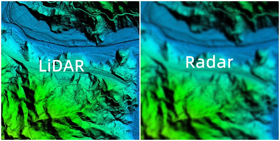
What is the Difference Between Radar and LiDAR?
Radar and LiDAR are technologies designed for object detection, each with its distinct features.
Radar employs radio waves to gauge the time taken for signals to return after hitting objects. This adaptability makes it ideal for various weather conditions, commonly finding use in aviation and weather monitoring due to its ability to penetrate obstacles and work in adverse weather.
LiDAR, on the other hand, uses laser light to measure distances and create detailed 3D maps. Known for its precision, LiDAR calculates distances by analyzing the time taken for laser pulses to return after hitting objects. It excels in accuracy and is extensively utilized in autonomous vehicles, environmental monitoring, and forestry, contributing to the creation of precise digital elevation models.
The choice between radar and LiDAR often depends on the specific demands of the application. Radar, with its adaptability and longer range, suits broader surveillance contexts, while LiDAR, with its precision and detailed mapping capabilities, excels in scenarios requiring accurate object recognition and intricate environmental modeling.
Read More


Every drone needs a brain.
Without it, you’re holding an expensive paperweight with spinning blades.
That brain is called a flight controller—but most people have no idea what it actually does.

Let’s be honest: the drone world loves its acronyms. UAV, UAS, drone, RPAS, UCAV, FPV–it’s an alphabet soup. And most people use them like they’re the same thing.
They’re not.
And here’s why that matt

JOUAV Product News and Use Cases
Fixed-Wing VTOL Drones Insights and Industry Trends
Invitations to online demo events