Every drone needs a brain.
Without it, you’re holding an expensive paperweight with spinning blades.
That brain is called a flight controller—but most people have no idea what it actually does.
What Exactly is LiDAR for Archaeology?
LiDAR (Light Detection and Ranging) is a revolutionary remote sensing tool that has become indispensable to modern archaeology.
By emitting laser pulses and measuring their reflection, LiDAR creates precise 3D maps of landscapes, revealing hidden archaeological features invisible to the naked eye.
Unlike traditional methods that rely on labor-intensive excavation or satellite imagery limited by vegetation, LiDAR penetrates dense forests, arid plains, and even urban sprawl to expose the fingerprints of ancient civilizations.
How Does LiDAR Work in Archaeology?
At its core, a LiDAR system combines lasers, GPS, and advanced software to map terrain. Here's how it works:
- Emitting the Laser Pulse: A LiDAR system sends out a focused laser pulse toward the ground. These pulses are emitted at staggering speeds—up to a million times per second—from an aircraft, drone, or ground-based scanner.
- Capturing the Reflection: When the laser hits an object (a tree, a building, or an ancient stone structure), it reflects to the LiDAR sensor. The sensor records the exact time it takes for each pulse to complete its round trip.
- Calculating Distance: Using the formula Distance = (Speed of Light × Time Elapsed) / 2, the system determines how far each object is from the source. The division by two accounts for the laser's round-trip journey (to the object and back).
- Building a 3D Point Cloud: By repeating this process millions of times, LiDAR generates a dense "point cloud"—a massive collection of data points in three-dimensional space. Each point represents a precise location on the surveyed landscape.
- Filtering and Analysis: Advanced software filters out noise (e.g., vegetation, modern infrastructure) to isolate the ground surface. Archaeologists then analyze the remaining data to identify anomalies: the faint imprint of a buried wall, the geometric shape of a plaza, or the elevation changes of an ancient mound.

Different Types of LiDAR Used in Archaeology
LiDAR versatility makes it a cornerstone of modern archaeology, with different systems tuned to specific environments and research objectives.
Airborne LiDAR
Mounted on aircraft, helicopters, or unmanned drones, airborne LiDAR projects laser pulses downward as an aircraft heads over a target location. The pulses penetrate gaps in vegetation (e.g., forests, mangroves) to produce a map of the ground surface below.
The advantage of airborne LiDAR is its speed and extent. A single survey can cover several square kilometers in hours, giving a regional context to ancient civilizations.
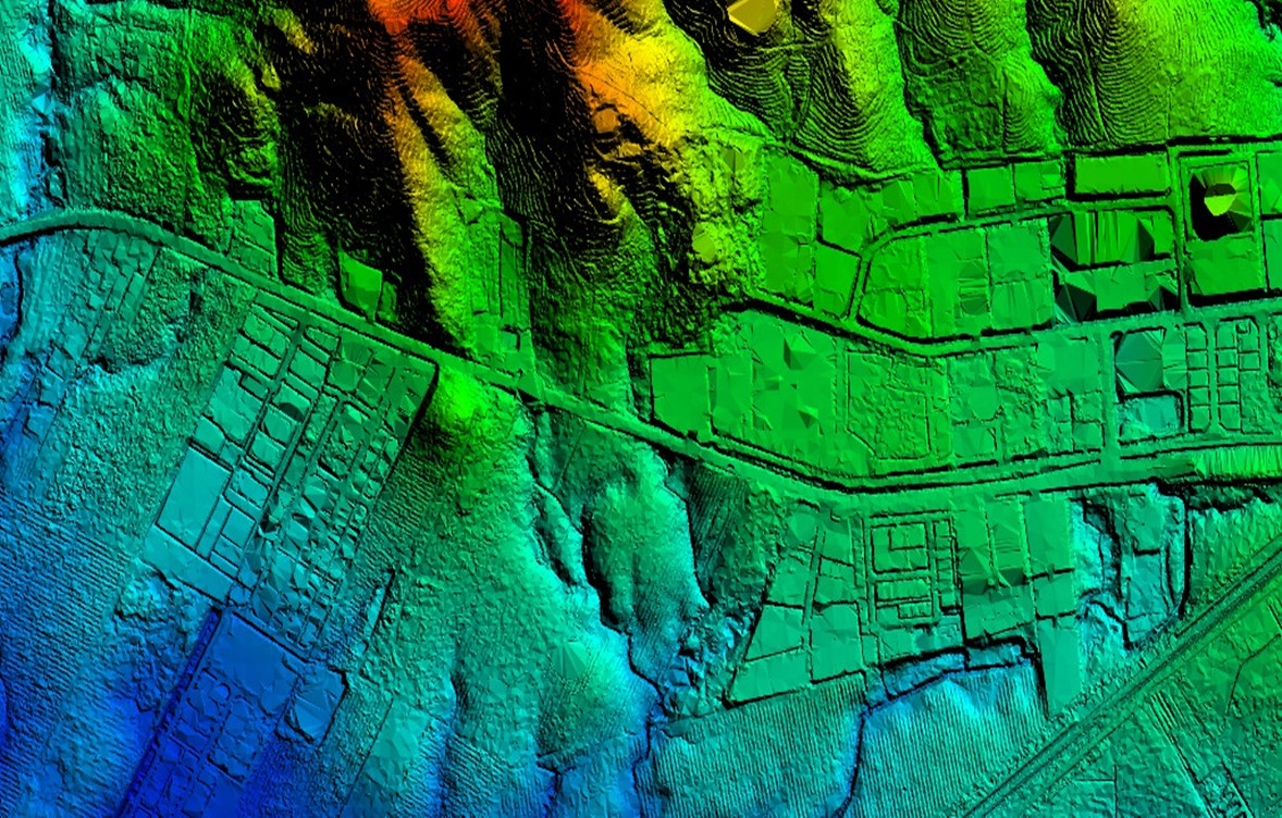
For example, the JOUAV PH-20, equipped with the JoLiDAR-1000 LiDAR system, operates at a laser pulse frequency of 500 kHz and flies at an altitude of 200 meters. With a 50% sidelap, it can map up to 5 square kilometers in a single flight, delivering imagery with a ground resolution of 3 centimeters.

In Zhaoqing, Guangdong Province, the JOUAV PH-20 drone, equipped with the JoLiDAR-120, was deployed to take off along a highway for a geological hazard inspection. Read the full case here.
Watch the full video below to learn more about this case study:
What is LiDAR Used for in Archaeology?
By stripping away natural and modern obstructions, LiDAR answers questions about how ancient societies lived, adapted, and interacted with their environments. Below, we explore its core applications
Discovering Hidden Structures Beneath Vegetation
Dense forests and jungles have long shielded archaeological sites from discovery. LiDAR's ability to penetrate vegetation has rewritten maps of ancient civilizations.
In Mexico's Yucatán Peninsula, lasers exposed a vast Maya ceremonial complex beneath a 30-foot-tall jungle canopy, complete with pyramids and ball courts.
Similarly, airborne LiDAR in the Amazon Basin revealed sprawling pre-Columbian settlements with geometric earthworks, challenging the notion of an "untouched" rainforest.
These discoveries highlight LiDAR's role in correcting historical biases, proving that regions once deemed marginal were hubs of human activity.
Mapping Ancient Urban Networks
LiDAR excels at reconstructing entire cities, revealing infrastructure invisible to ground surveys.
In Cambodia, it mapped Angkor Wat's medieval urban sprawl, including reservoirs, roads, and neighborhoods that supported a population rivaling modern cities.
In 2023, a LiDAR survey of the ancient Mayan city of Calakmul uncovered a hidden network of elevated highways (sacbeob) connecting political and religious centers.
Such maps provide insights into urban planning, trade, and social hierarchies, showing how civilizations managed resources and connectivity.
Documenting Cultural Heritage at Risk
War, climate change, and urbanization threaten archaeological sites. LiDAR provides a non-invasive way to digitally preserve endangered heritage.
In Syria, terrestrial LiDAR documented the ruins of Palmyra before and after ISIS destruction, creating a blueprint for potential reconstruction
In coastal regions like Bangladesh, bathymetric LiDAR tracks submerged settlements threatened by rising sea levels, preserving records of human adaptation to environmental change.
Studying Agricultural and Land-Use Patterns
Ancient societies shaped landscapes to sustain populations, and LiDAR reveals these adaptations.
In Peru’s Andes, lasers identified terraced fields and irrigation canals that supported Inca agriculture at high altitudes.
In England, LiDAR detected medieval "ridge and furrow" farming patterns under modern pastures, illustrating how feudal communities maximized arable land.
Such data helps archaeologists understand food production, labor organization, and resilience to climate shifts.
Investigating Ritual and Funerary Landscapes
LiDAR uncovers sacred spaces, burial sites, and ceremonial infrastructure.
In Ireland, airborne surveys revealed a 5,500-year-old megalithic tomb hidden under a peat bog, its entrance aligned with the solstice sunrises.
In Ohio, USA, LiDAR mapped the Hopewell culture's geometric earthworks—ceremonial enclosures used for rituals 2,000 years ago. These findings deepen our understanding of spiritual practices and cosmologies.
Tracking Human-Environment Interactions
By reconstructing ancient landscapes, LiDAR shows how societies responded to environmental pressures.
In the American Southwest, it identified Ancestral Puebloan cliff dwellings built during prolonged droughts, highlighting strategies for survival.
In the North Sea, bathymetric LiDAR located Doggerland—a submerged Mesolithic hunting ground flooded 8,000 years ago—offering clues about early human migration as ice sheets melted.
Supporting Indigenous Knowledge and Collaboration
LiDAR often validates oral histories and Indigenous land stewardship.
In British Columbia, Canada, lasers exposed 150-year-old salmon traps designed by the Heiltsuk Nation, aligning with elders' accounts of ancestral fishing practices.
Similarly, in Australia, LiDAR mapped ancient Aboriginal aquaculture systems, reinforcing Indigenous claims to land and water management expertise.
Enhancing Public Engagement and Education
High-resolution LiDAR models are used in museums, virtual tours, and augmented reality apps to make archaeology accessible.
For example, a 3D LiDAR reconstruction of Pompeii's ruins allows users to "walk" through the city's streets before the volcanic eruption.
Such tools democratize history, fostering global interest in cultural preservation.
Why LiDAR Outshines Traditional Archaeology?
Traditional archaeological methods, while foundational to the discipline, often face limitations in speed, invasiveness, and scalability.
Speed and Efficiency
LiDAR dramatically accelerates data collection. Airborne systems can survey vast landscapes—thousands of square kilometers—in a matter of hours or days, a task that would take decades using ground-based surveys.
This efficiency allows researchers to focus on analysis rather than labor-intensive fieldwork, enabling rapid progress in mapping ancient urban networks, agricultural systems, or ceremonial landscapes.
Non-Invasive Preservation
Excavation inherently disturbs archaeological sites, risking damage to fragile artifacts or contextual layers. LiDAR eliminates this risk by capturing data remotely. It preserves sites in their original state, allowing future generations of researchers to study them with more advanced technologies.
This non-invasive approach is especially critical for culturally sensitive locations, such as burial grounds or sacred sites, where physical intrusion is ethically problematic.

Cost-Effectiveness
While LiDAR technology requires an initial investment in equipment and expertise, its long-term savings are significant. By identifying promising sites before excavation, it reduces wasted time and resources on unproductive digs.
Large-scale surveys that once demanded extensive funding for labor, permits, and logistics are now streamlined, making archaeological projects more accessible and sustainable.
Reduced Risk in Dangerous Areas
Archaeological sites often lie in challenging environments: dense jungles, politically unstable regions, or areas contaminated by landmines. LiDAR allows researchers to survey these locations remotely, avoiding physical danger.
For example, drones equipped with LiDAR can map volcanic slopes, war-torn regions, or unstable coastal zones without exposing teams to risk.
Limitations of LiDAR in Archaeology
While LiDAR has revolutionized archaeology, it is not a panacea. The technology faces significant hurdles, from financial barriers to technical constraints, that researchers must navigate to maximize its potential.
High Costs
LiDAR systems, particularly airborne and bathymetric variants, require substantial financial investment. High-resolution sensors, aircraft rentals, and specialized software can push project costs into the hundreds of thousands of dollars—a prohibitive sum for many academic teams or underfunded heritage organizations.
Even when equipment is accessible, processing raw data demands expertise in geospatial analysis, adding labor and training expenses. While drone-based systems have lowered costs for smaller projects, large-scale surveys remain financially out of reach for many.
Data Overload
LiDAR generates colossal datasets. A single airborne survey can produce terabytes of data, including millions of 3D points that require filtering, classification, and interpretation.
Without advanced software or machine learning tools, distinguishing archaeological features (e.g., ancient walls) from natural formations (e.g., rock outcrops) becomes a needle-in-a-haystack challenge. This overload risks overwhelming researchers, delaying analysis, or leading to missed discoveries buried in the noise.
Terrain Limits
LiDAR's effectiveness varies dramatically across landscapes:
- Dense Vegetation: While LiDAR penetrates forest canopies better than satellites, extremely thick foliage (e.g., bamboo groves) can block pulses, leaving gaps in data.
- Flat or Featureless Terrain: Deserts, grasslands, or plowed fields offer little topographic contrast, making it difficult to identify subtle human-made structures.
- Underwater Environments: Bathymetric LiDAR struggles in murky waters or depths beyond 50 meters, limiting its use for marine archaeology.
- Urban Areas: Modern infrastructure (e.g., buildings, roads) can obscure or mimic ancient features, complicating analysis.
Case Studies of LiDAR in Archaeology
The Maya Megalopolis of Guatemala
Guatemala's Petén jungle, dense and nearly impenetrable, hid countless Maya structures for centuries. Traditional surveys uncovered only fragments of the civilization's urban footprint.
The 2018 PACUNAM LiDAR Initiative scanned 2,100 km² of jungle, firing billions of laser pulses to strip away vegetation.
The lasers revealed 61,000+ structures, including pyramids, elevated highways, irrigation systems, and defensive fortifications. The data showed the Maya Lowlands supported millions of people—far more than previously estimated—with advanced infrastructure rivaling modern cities.
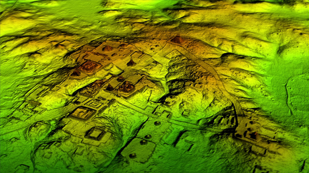
In the jungles of Guatemala, a high-tech laser mapping technology has uncovered previously unknown cities and thousands of interconnected structures. Image credit: National Geographic.
Angkor Wat's Hidden Metropolis (Cambodia)
Angkor Wat's temples were well-studied, but the surrounding landscape remained a mystery due to dense forest and modern development.
Airborne LiDAR surveys in the 2010s mapped 3,000 km² around the temple complex.
Researchers uncovered a sprawling medieval urban network with canals, roads, and neighborhoods, suggesting Angkor supported up to 900,000 people at its peak. The lasers also revealed massive water management systems that failed due to climate shifts, contributing to the city's collapse.
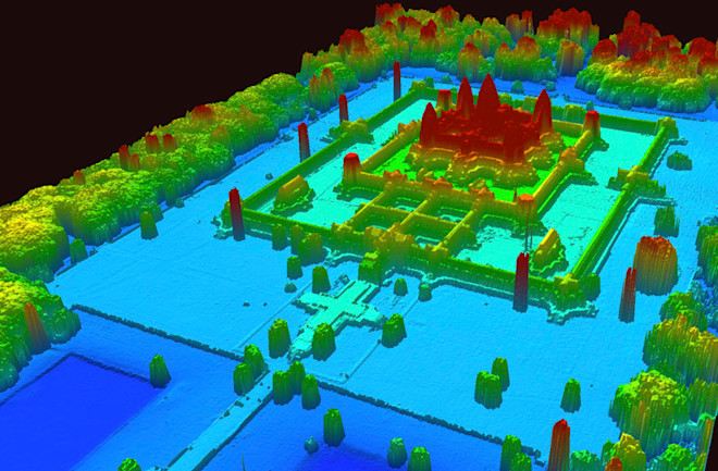
A 3D elevation map of Angkor Wat, created using LiDAR, reveals variations in terrain. Image credit: PT McElhanney / Khmer Archaeology LiDAR Consortium.
The "Lost City of the Monkey God" (Honduras)
Legends of a mythical "White City" in Honduras' Mosquitia rainforest persisted for centuries, but the jungle's remoteness thwarted explorers.
A 2012 airborne LiDAR survey targeted the region, penetrating layers of untouched rainforest.
The lasers exposed a sprawling settlement with pyramids, plazas, and terraces dating to a mysterious pre-Columbian culture (1000–1400 CE). Artifacts later confirmed the site's significance, including ritual vessels and stone sculptures.
Viking Age Secrets in Scandinavia
Norway's rugged terrain and agricultural landscapes obscured Viking burial sites and settlements.
High-resolution airborne LiDAR scanned coastal regions, identifying subtle elevation changes in farmland.
Researchers located Viking ship burials, longhouses, and agricultural fields invisible to ground surveys. In Denmark, LiDAR revealed a massive 10th-century Viking fortress near Copenhagen, suggesting a centralized defense network.
The Amazon's Ancient Garden Cities
The Amazon was long considered a "pristine" wilderness with no large-scale pre-Columbian settlements.
A 2022 survey of Bolivia's Llanos de Mojos region deployed LiDAR to scan savannahs and forest islands.
The lasers mapped 26 interconnected settlements with ceremonial centers, causeways, and water reservoirs, built between 500 and 1400 CE. The cities were surrounded by intentional "forest islands" for agriculture, proving Indigenous societies shaped the Amazon millennia before European contact.
Read More


Let’s be honest: the drone world loves its acronyms. UAV, UAS, drone, RPAS, UCAV, FPV–it’s an alphabet soup. And most people use them like they’re the same thing.
They’re not.
And here’s why that matt
An airborne cargo drone is exactly what it sounds like: an unmanned aircraft built to carry stuff. Not tiny packages for a suburban backyard – real cargo. From medical supplies to industrial parts.
An

JOUAV Product News and Use Cases
Fixed-Wing VTOL Drones Insights and Industry Trends
Invitations to online demo events