At 2:27 PM on a storm-lashed afternoon in July 2025, a small fishing boat capsized off the coast of Gulei, Zhangzhou.
Two men were thrown into violent waters. Winds howled at gale force. Waves surged
When Thailand’s Geo-Informatics and Space Technology Development Agency (GISTDA) decided it was time to refresh the digital maps of Khon Kaen, Nakhon Ratchasima, and Nakhon Si Thammarat, the motivation was simple: cities were changing too fast. Roads had shifted, new neighborhoods appeared out of nowhere, and decades-old basemaps no longer matched what was happening on the ground. For urban planners, working with outdated geospatial data was like driving a car with fogged-up windows.
To clear that fog, GISTDA launched an ambitious aerial survey initiative—one that demanded high accuracy, complete coverage, and the reliability to support national-level decision-making.
Why Systronics Needed More Than Just a Drone?
GISTDA turned to Systronics Co., Ltd., a trusted local partner with deep geospatial experience. But Systronics knew that this wasn’t a routine survey job. Each municipality included dense residential cores, narrow alleyways, intricate infrastructure, and growing suburbs that stretched far beyond their official boundaries.
“We needed a platform that wouldn’t just get the job done—it had to get the job right,” said a Systronics project lead. “Urban areas punish the wrong drone choice. We needed accuracy, endurance, oblique coverage, and zero excuses.”
The answer was JOUAV’s CW-15 VTOL fixed-wing UAS, paired with the CA502R oblique camera and RTK/PPK positioning. With this setup, Systronics could capture every rooftop, road, and façade with the clarity and accuracy GISTDA required.
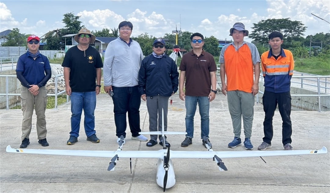
GISTDA and Systronics survey teams on-site with the JOUAV CW-15 during large-scale urban mapping operations.
Taking Off Where Others Can’t
Urban mapping projects usually start with a headache: where do you take off?
The CW-15 dissolved that problem instantly. Vertical takeoff meant no runways, no long fields, and no special infrastructure. The drone lifted smoothly from compact open spaces at the edge of each city before transitioning to fixed-wing flight to cover the entire municipality.
“The CW-15 took away so many operational worries,” said a Systronics flight operator. “We could fly from places other drones simply couldn’t.”
Once airborne, the CA502R camera got to work. With more than 120 megapixels of combined vertical and oblique imagery, the system captured buildings from every angle, preserving details that traditional nadir-only mapping misses. In cities with tight urban canyons and complex building clusters, this made all the difference.
Accuracy That Holds up to National Scrutiny
Collecting imagery is only half the story. To produce authoritative 2D and 3D geospatial datasets, Systronics established an extensive network of GCPs and Checkpoints using GNSS-Static surveying tied directly to Thailand’s National CORS network. This ensured centimeter-level UTM coordinates (WGS84) and elevations referenced to mean sea level.
“GISTDA’s standards are strict—very strict,” a Systronics survey engineer said with a laugh. “But with the CW-15’s RTK/PPK system and our ground control work, we knew we could match their benchmarks.”
Every dataset—from orthophotos to DTMs, DSMs, point clouds, and 3D textured meshes—was processed with rigorous photogrammetric workflows. Overlapping flight paths, precise georeferencing, and multi-angle coverage made the resulting models startlingly realistic.
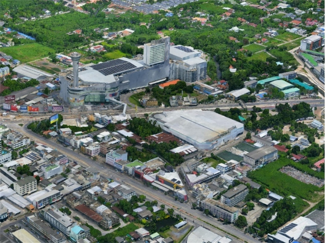
High-resolution 3D reconstruction produced from CW-15 oblique data, capturing complex urban features with survey-grade accuracy.
Turning Raw Imagery into Living Digital Twins
As the processing progressed, the three cities began to reveal themselves digitally, more detailed than planners had ever seen. Rooflines popped with definition. Building façades appeared with a clear texture. Terrain surfaces aligned precisely with known elevations. Roads, canals, power lines, and alleyways looked exactly as they do in everyday life.
“You could zoom into any corner of the city and see the data respond instantly and accurately,” one GISTDA analyst commented during validation. “It felt like we were looking at a true digital twin.”
The datasets were seamlessly integrated into Thailand’s national geospatial platform, Sphere, giving planners, engineers, and policymakers a modern, reliable foundation for smart-city development, infrastructure management, and land-use planning.
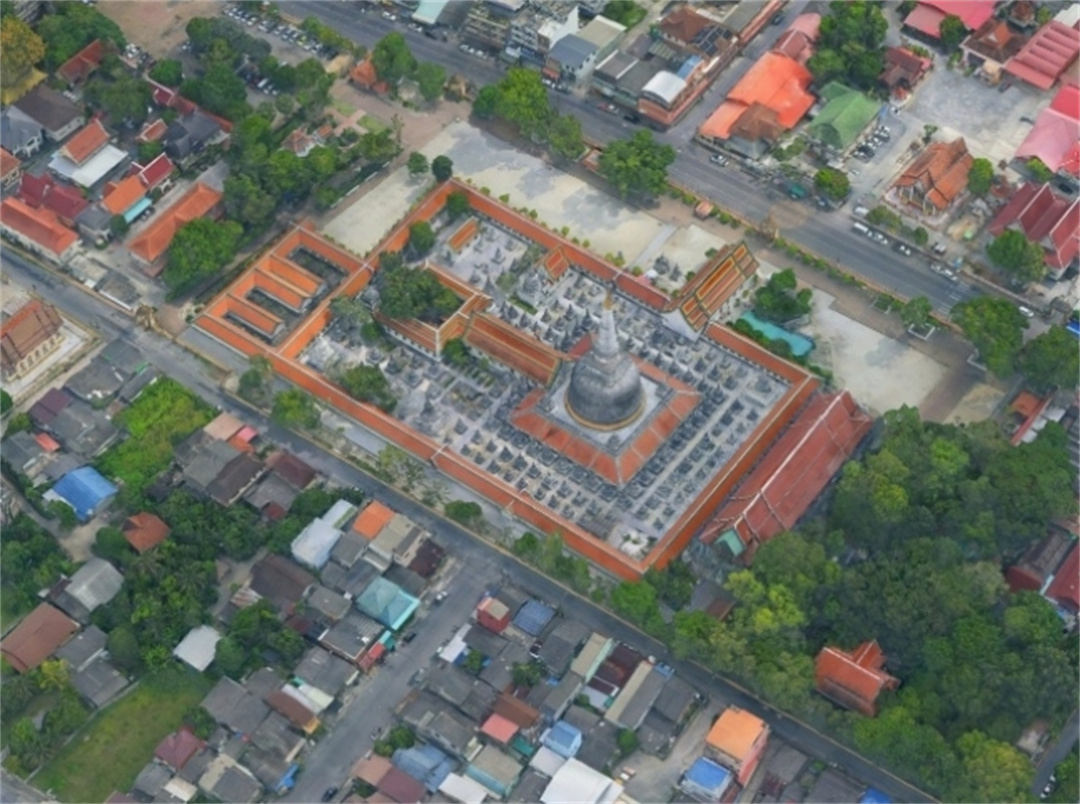
High-detail 3D model generated from CW-15 oblique imagery, showing precise building structures and urban surfaces.
A Quality Assessment With No Surprises
When GISTDA conducted its final accuracy checks, the results came back exactly as Systronics expected:
fully compliant, complete, and consistent with every technical requirement.
“The data quality didn’t just meet the specifications—it set a new benchmark for what urban drone mapping can deliver in Thailand,” said a GISTDA project manager.
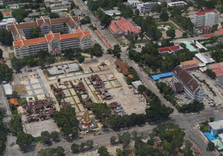
Close-up view of the CW-15–derived 3D textured model, revealing accurate rooftop geometry and façade details.
A Project That Redefined What’s Possible
This three-city initiative wasn’t simply a technical exercise—it was a demonstration of what can happen when advanced UAV technology meets experienced hands. The CW-15’s endurance, imaging clarity, and positioning precision provided Systronics with a dependable tool for producing national-grade geospatial information under challenging real-world conditions.
For GISTDA, the result is more than a set of maps. It is a modern spatial foundation for urban governance, planning, and development—one that reflects cities as they truly are today.
And for organizations facing similar mapping challenges, this project offers a clear takeaway:
When accuracy matters, when the landscape is complex, and when the data will shape real decisions, the JOUAV CW-15 consistently delivers.
“We’ve flown many systems over the years,” a Systronics team leader reflected, “but the CW-15 gave us the confidence to take on large, urban, high-precision projects without hesitation. It’s not just a drone—it’s a dependable partner.”
Contact us today to discuss your next aerial surveying project and learn how JOUAV can help you achieve compliance and superior data quality.
More Use Cases


Chongqing’s Qinba Mountains are basically a giant green wall protecting the region. But there’s a problem – pine wood nematodes are eating through it. Fast.
The forestry department n

When TotalEnergies set out to build one of Southeast Asia’s largest solar and battery storage projects—spanning 12,000 hectares across the dense acacia forests of Riau, Indonesia—they faced a problem

JOUAV Product News and Use Cases
Fixed-Wing VTOL Drones Insights and Industry Trends
Invitations to online demo events