At 2:27 PM on a storm-lashed afternoon in July 2025, a small fishing boat capsized off the coast of Gulei, Zhangzhou.
Two men were thrown into violent waters. Winds howled at gale force. Waves surged
Guangdong Power Grid Company invests in, constructs, and operates power grids in the southern provinces of Guangdong. This company manages 19 municipal power supply bureaus, a multitude of production sites, and more than 2,000 substations.
Mountainous terrain makes power line inspection difficult
Power line inspection plays a key role in a power transmission system to confirm the safety and the continuous operation of power services. Traditional methods need a team of people to climb poles, inspect vegetation, and cover tens of miles per day. But Guangdong has complicated terrains with many high rough mountains and dense forests. The lack of roads makes walking or driving nearly impossible, not to mention extremely time-consuming.
Using drones for power line inspection
Guangzhou Power Grid Company, as one of the forward-thinking grid operators, has relied on drone data for the past few years as a way to collect inspection data of power line defects and obstacles from vegetation to infrastructure. They began mapping with DJI Phantom 4, and over the next few years, they had a large fleet.
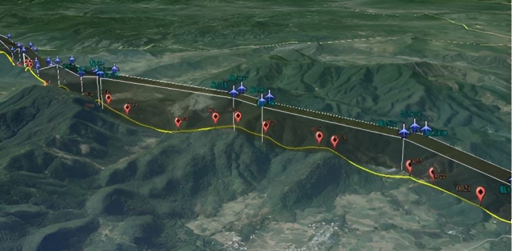
A map of the CW-25D's patrol route as displayed by the ground control station.
"So the DJI Phantom 4 was a helpful tool because it acquire detailed pictures by hovering in the air at a closer distance to the objects. But their patrol distance and time duration from the ground control station is very small", Will Chow said, Technical Manager at Guangdong Power Grid company.
VTOL drones for long-distance inspection
In 2018, this company upgrade to the JOUAV CW-25D VTOL drone. "Power lines are often built on top of mountains and in deep valley areas. So we choose CW-25D, which can take off anywhere and hover over the power lines. Meanwhile, the drone has 6 times longer flight time than DJI Phantom 4", Will said.
Improved wind-tolerance and water-proof features
The weather in Guangzhou is very changeable, at one moment it is sunny, and at another, it will rain. Fortunately, the JOUAV drone is wind and water-resistant and can fly smoothly in extreme weather.
"We are enjoying the work. Also, when you look at the wind endurance, you can fly in 17 m/s winds. All I witnessed was the flight of the JOUAV and even in extreme winds it landed safely", Will described.
High inspection efficiency
In more than 20 days, CW-25E had more than 60 flights to cover 1060km transmission lines. On average, each flight can inspect 120 tower bases. Its work efficiency is 36 times that of a multi-rotor.
"Data collected by CW-25E allows us to create 3D models that can be used for defect detection and analysis. We primarily find sagging power lines and vegetation close to power lines." Mark Xu commented, head of UAV operations at Guangdong Power Grid.
JOUAV CW-25E | Multi-rotor | |
Coverage | 72km | 2km |
Number of towers | 144 | 4 |
Different payloads can be carried
With a maximum payload capacity of 6kg, CW-25E is a multipurpose and modular vehicle that allows carrying different payloads like ortho cameras, oblique cameras, LiDARs, and gimbal cameras, depending on the specific task to fulfill.
- Read more: 3 case studies of power line inspections using UAV LiDAR
- Read more: Inspecting 52km of Powerlines for China Southern Power Grid in 2hrs
Guangdong Power Grid company has used CW-25E equipped with a CA502R 120MP Oblique Camera that shows every cm of the power lines or tower construction to detect the defects. Besides, they also deployed CW-25E with JoLiDAR-LR to detect overgrown vegetation close to the power lines or poles.
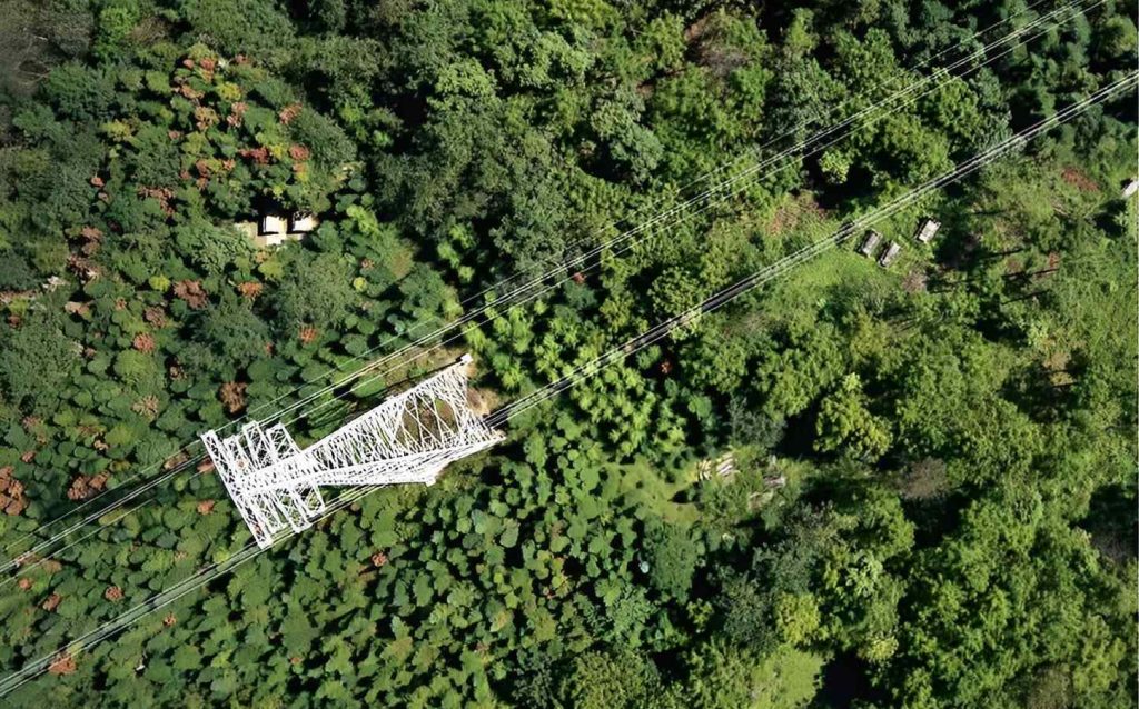
Oblique imagery of Guangdong power line inspection
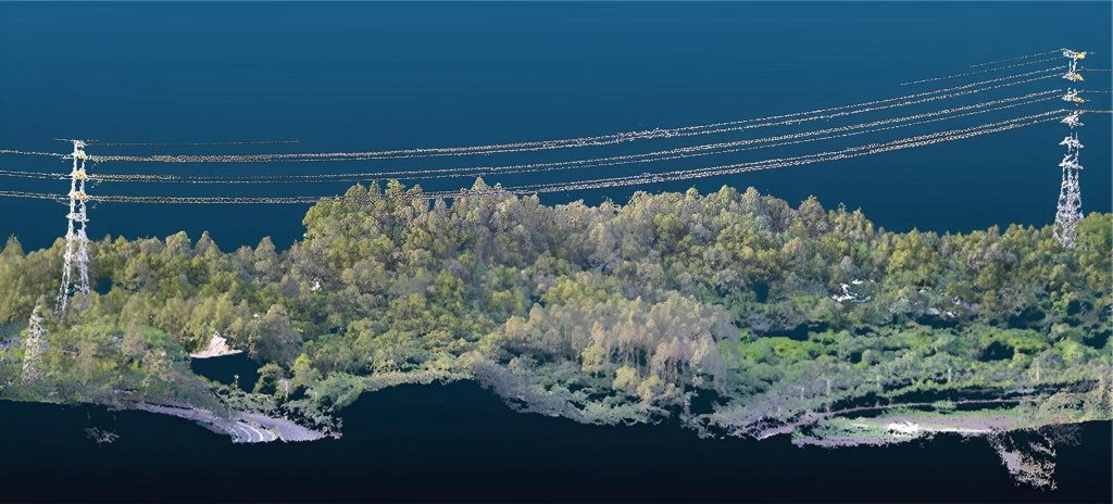
3D point cloud of Guangdong power line inspection
Fully automated, safe, and convenient drones
On top of that, the automation integrated into JOUAV allows the inspection team to thoroughly check the entire system before takeoff and see that these checks are fully executed. It is impossible for a drone to take off unless it is ready in terms of its motors, camera connections, and other vital signs. This gives pilots great peace of mind that they can both fly safely and capture the best data possible.
After the operator presses the takeoff button, the CW-25D will fly autonomously on a planned course. With Terrain Follow Flight Mode, CW-25D will keep a set distance from the ground to achieve a consistent GSD. That means you can fly the drone up a hill without having to constantly adjust its height to keep it from running into the ground.
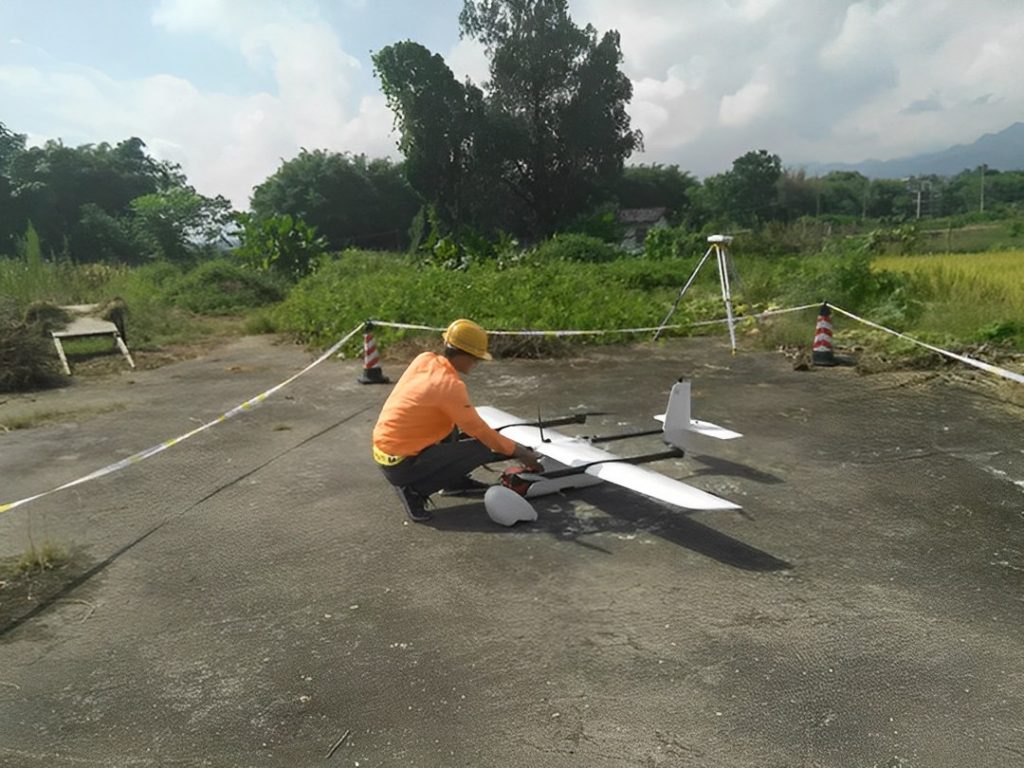
The pilot of Guangdong power line inspection
Will drones revolutionize power grid operations?
But drones aren't just valuable for inspections. They can also be used during the development of power lines to survey and scan locations and create 3D models and simulations of future installations. They can be used throughout the process of developing and setting up power lines to ensure that the development work goes smoothly. And they can be used for other elements of the power system, such as inspecting electrical equipment and power facilities.
As technicians become more accustomed to working from photographs, bird's-eye views, and mockups, they will also be more effective at quickly diagnosing problems without having to introduce high-risk human intervention. The energy market is being transformed by drone technology, leading to lower costs, reduced risk, and better uptime.
More Use Cases


Chongqing’s Qinba Mountains are basically a giant green wall protecting the region. But there’s a problem – pine wood nematodes are eating through it. Fast.
The forestry department n

When TotalEnergies set out to build one of Southeast Asia’s largest solar and battery storage projects—spanning 12,000 hectares across the dense acacia forests of Riau, Indonesia—they faced a problem

JOUAV Product News and Use Cases
Fixed-Wing VTOL Drones Insights and Industry Trends
Invitations to online demo events