Have you ever watched a drone hover effortlessly over a construction site, inspect a wind turbine blade, or deliver medical supplies to a remote village?
That drone was almost certainly a multirotor.
What is Hydrographic Surveying?
In essence, hydrographic surveys are like underwater X-rays, measuring and mapping the physical characteristics of oceans, seas, rivers, and lakes. This detailed information provides a wealth of knowledge about the underwater terrain, including:
- Water depth: This is the primary focus, crucial for safe navigation and understanding the underwater landscape.
- Seafloor Composition: Knowing the type of seabed (sand, rock, etc.) is essential for planning infrastructure projects and understanding marine ecosystems.
- Submerged hazards: Identifying shipwrecks, underwater ridges, or other obstacles is vital for safe navigation.
- Water properties: Some surveys may measure factors like salinity, currents, and tides, depending on the project's specific needs.
This comprehensive data is typically presented in nautical charts – the GPS of the sea. However, the applications of hydrographic surveys extend far beyond navigation. The information is crucial for environmental research, civil engineering projects, managing marine resources like fisheries, and even understanding delicate marine ecosystems.
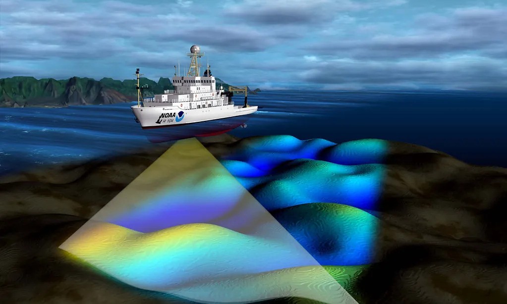
Image credit: NOAA's National Ocean Service
Equipment and Techniques Used in a Hydrographic Survey
Gone are the days of manual labor and guesswork. Modern hydrographic surveys rely on a sophisticated arsenal of equipment, employing sonar, lasers, and other cutting-edge technologies to ensure accuracy and efficiency.
Marking Equipment
Every hydrographic survey starts with proper marking. Surveyors use high-visibility, low-tack marking tape to designate survey points, GPS measurement endpoints, and underwater hazards like rocks, shipwrecks, and reefs. This brightly colored tape comes in various hues, each signifying a specific purpose:
- Orange: The universal color for marking underwater dangers.
- Yellow: Often used to designate GPS measurement endpoints.
- Red & White: Offer flexibility for marking various features.
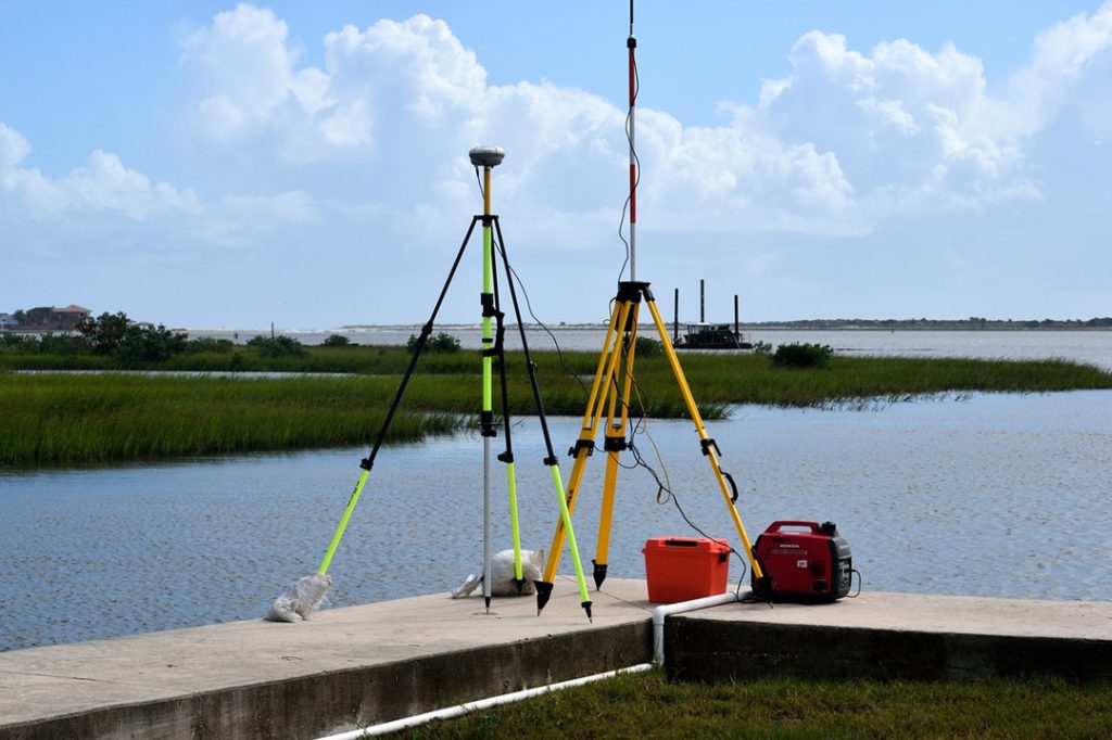
GPS and Optical Devices
Global Positioning Systems (GPS) are a cornerstone of modern hydrography. These devices provide surveyors with real-time, accurate coordinates for each survey point, eliminating the need for physical markers. Many advanced GPS units boast built-in inclinometers to determine elevation at each point.
For situations where GPS isn't an option, traditional surveying instruments like theodolites, alidades, and levels offer valuable alternatives, albeit with varying degrees of accuracy and portability. Theodolites reign supreme in terms of precision, while alidades provide a more portable option with a slight compromise on accuracy. Levels, while less precise, still hold a place in specific hydrographic surveys.
Sonar
Sonar technology revolutionized hydrographic surveys by using sound waves to measure water depth. These marvels of underwater exploration come in various forms, each catering to specific needs:
- Side-scan sonar: Ideal for surveying large, near-shore areas, creating a detailed image of the seabed, and revealing submerged obstructions.
- Echo sounders: Perfectly suited for measuring depths in shallow waters.
- Multi-beam sonar: The undisputed champion of accuracy, multi-beam sonar transmits sound pulses in all directions, offering a comprehensive picture of the underwater terrain and pinpointing potential hazards.

Video Equipment
Video cameras play a crucial role in hydrographic surveys. They capture invaluable footage of underwater features, aiding surveyors in monitoring crew members in low-visibility conditions. Additionally, video documentation allows for post-survey review and adjustments.
Commonly used video equipment includes video cameras, digital still cameras, and GoPros. When selecting a camera, water resistance and the ability to withstand movement and vibrations are key considerations.
Electronic Navigation Tools
Electronic navigation tools are a surveyor's trusted companion. These versatile devices provide essential information like current and tidal data, weather forecasts, and marine traffic alerts. Some models boast mapping software for creating surveys and overlaying existing charts.
Additionally, many integrate GPS technology for seamless navigation and some even feature sonar functionality, referred to as Electronic Navigation with Sonar (ENSON). ENSON systems are invaluable for hazard identification, charting survey progress, and conducting surveys in low-visibility environments.
Depth Measurement Tools
Beyond sonars, hydrographic surveys employ specialized equipment for precise depth measurement. Rotating beams determine depths directly below a stationary position, while strainers (weighted lines with buckets) estimate average depths over a designated area. While highly accurate, these methods require meticulous execution and choosing the right tool for the job.
Bottom Profiling Equipment
For shallow water exploration and hazard identification, bottom profiling equipment steps up. This category encompasses side-scan sonar, multi-beam sonar, echo sounders, video cameras, rotating beams, and strainers.
Similar to multi-beam sonar, bottom profiling tools transmit sound pulses and interpret echoes to create a detailed picture of the seabed, which is particularly valuable in shallow areas or locations with limited visibility.
How is a Hydrographic Survey Being Done?
Hydrographic surveying is a meticulous process that involves several stages, each crucial in ensuring the accuracy and reliability of the data collected.
Planning and Preparation
The first step in conducting a hydrographic survey involves meticulous planning and preparation. This stage includes defining the survey's objectives, scope, and the area to be surveyed. It's also essential to identify potential challenges, such as varying water depths, currents, and obstructions.
Depending on the survey's purpose, the team may need to consider tidal predictions, weather forecasts, and safety measures. The choice of equipment and technology to be used, such as sonar systems, GPS, and marking devices, is also determined at this stage.
Data Collection
Once the survey plan is in place, the next step is data collection. Survey vessels equipped with sonar systems, GPS, and other necessary equipment navigate the predetermined routes, collecting data continuously. Sonar systems emit sound waves, which bounce back upon hitting the seafloor or any underwater object.
The time it takes for the sound wave to return is recorded, providing data on water depth and the presence of any underwater features. GPS systems track the vessel's exact location, ensuring that the depth data is accurately linked to the corresponding geographic coordinates.
Data Processing
After data collection, the raw data is processed and analyzed. This involves converting the sonar readings and GPS data into a format that can be interpreted and used to create a detailed map of the surveyed area.
Data processing includes correcting any anomalies or inaccuracies in the data, such as those caused by waves, tides, or equipment errors. The processed data provides a comprehensive and accurate representation of the underwater terrain, including water depths, seabed composition, and the location of any features or obstructions.
Charting and Reporting
The final stage of the hydrographic survey process is charting and reporting. The processed data is used to create detailed charts or maps of the surveyed area. These charts provide a visual representation of the underwater terrain and include crucial details such as water depths, seabed features, and potential hazards.
In addition to the charts, a comprehensive survey report is prepared, detailing the survey's findings, any challenges encountered, and conclusions drawn from the data.
What are Hydrographic Surveys Used for?
Hydrographic surveys are the meticulous measurement of underwater landscapes, utilizing advanced technology to generate precise data with real-world consequences. Let's explore the impact of these surveys with specific examples:
Safeguarding Navigation
Bathymetric surveys, the cornerstone of hydrography, measure water depths to within centimeters. This data is used to create detailed nautical charts that guide ship captains.
Imagine a captain receiving a real-time update on their electronic navigation system, highlighting a previously unknown underwater pinnacle just meters from their course.
Hydrographic surveys prevent such near misses, ensuring the safe passage of billions of dollars worth of cargo and countless passengers each year.
Civil Engineering
Before embarking on massive infrastructure projects like harbor construction or dam building, engineers rely heavily on hydrographic surveys. These surveys provide a detailed picture of the underwater terrain, including water depth and the composition of the seabed.
This critical information allows engineers to design structures with the necessary support to withstand the forces of nature and ensure the longevity of these vital projects.
Land Reclamation Projects
Hydrographic surveys play a pivotal role in land reclamation projects. By meticulously mapping the seabed topography and composition, engineers can identify suitable locations for land expansion and assess the feasibility of such endeavors.
This precise data empowers them to make informed decisions that shape coastlines for future development.
Flood Control System Design
Understanding the underwater landscape is essential for designing effective flood control systems. Hydrographic surveys reveal potential flooding zones with centimeter-level accuracy.
Imagine city planners being able to pinpoint exactly where levees need to be reinforced or where natural drainage channels can be restored. This precise data allows for the creation of targeted flood control measures that protect lives and property.
Resource Management
Hydrographic surveys are not limited to the physical landscape. By mapping alluvial and silt deposits near water bodies, they aid in identifying fertile land with high agricultural potential.
Additionally, studying river discharge patterns using hydrographic data allows for a deeper understanding of erosion risks.
Armed with this knowledge, land management strategies can be implemented to promote sustainable agricultural practices.
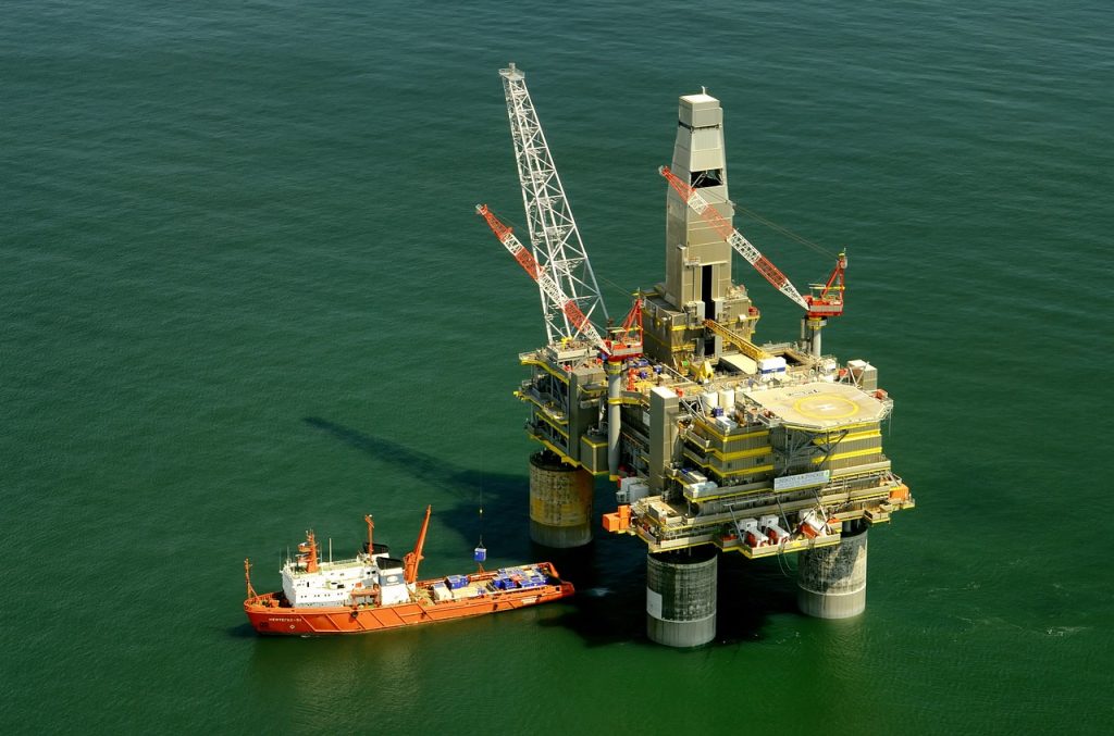
Offshore Industries
The offshore oil and gas industry heavily relies on hydrographic surveys. These surveys are used to remotely inspect underwater pipelines and oil rigs, identifying potential damage or wear and tear with pinpoint accuracy.
This allows for preventative maintenance, minimizing the risk of costly accidents and environmental disasters.
Additionally, hydrographic surveys ensure the safe and precise laying of new pipelines on the seabed.
Read More


Every drone needs a brain.
Without it, you’re holding an expensive paperweight with spinning blades.
That brain is called a flight controller—but most people have no idea what it actually does.

Let’s be honest: the drone world loves its acronyms. UAV, UAS, drone, RPAS, UCAV, FPV–it’s an alphabet soup. And most people use them like they’re the same thing.
They’re not.
And here’s why that matt

JOUAV Product News and Use Cases
Fixed-Wing VTOL Drones Insights and Industry Trends
Invitations to online demo events