Every drone needs a brain.
Without it, you’re holding an expensive paperweight with spinning blades.
That brain is called a flight controller—but most people have no idea what it actually does.
What is a Pipeline Right-of-Way?
A pipeline right-of-way (ROW) is a safety zone, typically around 50 ft (or 25 ft on either side of the pipe), established by the operator to ensure smooth and secure pipeline operations.
It spans across state lines, highways, fields, and parks, often cutting through places like residential neighborhoods, businesses, and schools.
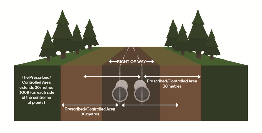
Pipeline right-of-way. Source from enbridge.com
These right-of-ways come into existence through agreements with landowners, also known as easements.
These agreements give the pipeline company limited rights, specifying the corridor area, permissions for inspections, repairs, testing, or emergencies, and whether multiple pipelines can be built.
Easements can be either permanent or temporary, providing extra space for construction.
Why do they matter? Well, they define clear paths, preventing damage to existing infrastructure and minimizing disruptions to large areas.
They act as a buffer zone, reducing the risk of accidents and unauthorized activities, and ensuring smooth pipeline operations.
Crucially, they respect landowners' rights by granting limited land access to the pipeline operator, striking a balance between both parties' interests.
Types of Pipelines and Their ROW Variations
Pipelines aren't a one-size-fits-all deal! Each type serves a unique purpose, leading to variations in size, pressure, and right-of-way (ROW) characteristics.
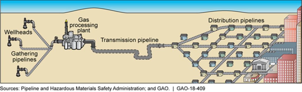
Gathering Pipelines
These small-diameter workhorses handle unrefined products within oil and gas facilities, linking wells to processing, refining, or storage areas.
Exploration companies own and operate them, and their ROWs are confined to production sites.
With diameters of 2-12 inches and lower pressures, their ROWs are narrower, usually 15-30 feet wide.
Key concerns include vegetation clearing and access maintenance.
Feeder Pipelines
Feeder pipelines transport processed or refined oil and natural gas from facility hubs to the main transmission lines.
Similar to gathering lines, their ROWs stay within facility boundaries and are managed by exploration companies.
With diameters of 6-24 inches, their ROWs are slightly wider, typically 20-40 feet, to accommodate increased volume and pressure.
Crucial considerations involve vegetation control and safety protocols.
Transmission Pipelines
These giants carry oil and gas across vast distances, often spanning provinces or even countries.
Specialized transmission companies own and operate them, and they boast large diameters, ranging from 24-48 inches, and high operating pressures.
Compressor stations strategically boost pressure along the route.
With the widest ROWs, typically 50-150 feet, careful planning and environmental considerations ensure safe operation and maintenance.
Distribution Pipelines
Finally, distribution pipelines deliver goods directly to end-users, such as natural gas for heating and cooking.
Local utility companies own and operate them, featuring diameters of 2-12 inches and lower pressures.
Their ROWs are typically narrow, ranging from 10-25 feet, following established infrastructure like roads and sidewalks.
Key concerns involve minimizing disruption and ensuring safety in populated areas.
How to Get A Pipeline ROW?
Getting a Pipeline Right of Way (ROW) involves a systematic approach that respects landowners' rights and addresses legal and practical considerations. Here is a detailed guide:
Route Selection and Planning
When you're in the business of transporting oil and gas through pipelines, choosing the right route is a critical first step that can make or break your project. It's not just about figuring out how much pipe you need; it's also about navigating legal and environmental considerations.
The goal is to move oil and gas safely, economically, and with minimal impact on the environment and landowners. This means taking into account factors like pipeline size, terrain, soils, and engineering requirements.
Pipeline Planning
Don't assume that the shortest route is the best route. Physical obstacles and environmental constraints often force you to take detours. To avoid costly oversights, your surveys need to equip engineers with detailed data on typography, geography, boundaries, and the environment.
This data helps in making decisions about corridor selection, route survey, and identifying foreign pipelines.
Selecting a Route During an Oil and Gas Pipeline Construction Project
Choosing the final route involves a deep dive into survey information. Highlight and map the constraints within the route corridor, setting the stage for negotiations, addressing construction limitations, predicting potential impacts, and planning construction methods and traffic management. Your survey should cover:
- A thorough examination of the route and the pipeline's construction environment.
- Surveying access roads, construction camps, staging, facilities, cathodic protection, and mainline valve sites.
- Conducting corridor design and above-ground facilities location surveys in the field.
- Collaborating with authorities and third parties to gather information about unknown developments, encroachments, underground obstructions, and other pipelines, services, and structures along the route.
- Engaging with landowners and land agents along the proposed route.
- Land and environmental corridor surveys should be wide enough to catch any features that could mess with pipeline installation and operation.
- Documenting the selected route on appropriately scaled alignment sheets, including significant point coordinates and contour lines.
- Identifying and dealing with geo-hazards through terrain evaluation and risk analysis to ensure the most suitable pipeline route.
- Early-stage terrain evaluations and assessments are a must. They cut down on design and construction time and costs, prevent the need for expensive fixes, make sure the site is restored, and keep the pipeline operational.
Traditionally, surveying for pipeline construction has been a slow, labor-intensive, and often dangerous process. But the rise of drone technology has brought a revolutionary change.
The JOUAV'S CW-15 VTOL Drones with JoLiDAR-120, combining 26MP cameras and 1430 LiDAR sensors. This provides detailed topographic maps for pipeline routes, identifying obstacles, slopes, and sensitive areas. The 3D models derived from drone data offer a visual understanding of terrain and obstacles, aiding in planning access roads, staging areas, and pipeline crossings with precision. This streamlined approach ensures efficient construction processes while minimizing environmental impact.
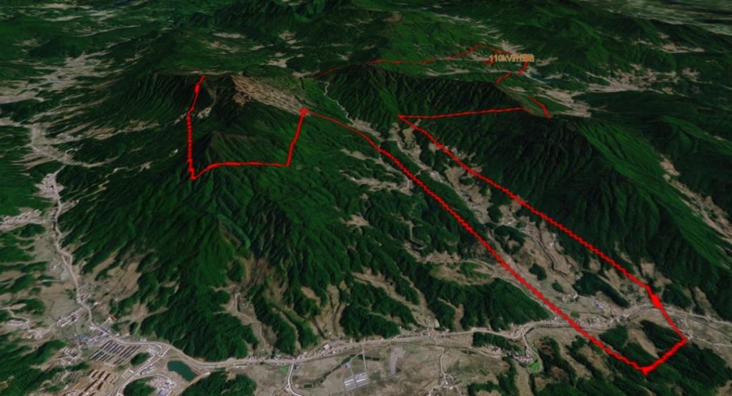
Guohong New Energy Company employed the CW-15, equipped with JoLiDAR-120, to gather precise 1:2000 point cloud data for an oil and gas pipeline construction project in Fengxin County. Despite the substantial height differences exceeding 1200 meters in the survey area, the elevation error was impressively minimal, measuring only 10.4 cm.
Negotiation and Acquisition
A skilled right-of-way agent plays a pivotal role in the success of any project, relying on the ability to establish connections, listen effectively, and employ strategic negotiation techniques. The initial meetings set the tone for future relationships, emphasizing the importance of impressions.
Educational qualifications are crucial, and modern agents adhere to higher standards due to educational advancements, ethical guidelines, and associations like the International Right of Way Association. The emphasis is on creating partnerships that endure, backed by both words and deeds, resulting in win-win outcomes.
- Initial Planning: Collaboration with engineers, construction managers, and surveyors allowed for planning the pipeline route. While the ideal route would be a straight line, practical considerations such as existing structures, trees, and landowners had to be factored in.
- Identifying Landowners: Researching ownership through county appraisal districts helped compile a preliminary line list. This step involved gathering names, addresses, and phone numbers of affected landowners.
- First Meeting: Gaining survey permission was crucial, as it served as the introduction to landowners. Keeping project details minimal, the agent sought permission for surveyors to access properties.
- Confirming Ownership: Verification of ownership through deed records at the County Clerk's office was a vital task, ensuring clarity and avoiding complications during the acquisition phase.
- Negotiation: Engaging with landowners involved open communication and a focus on minimizing impact. Negotiations, though predominantly smooth, centered around financial considerations, with efforts made to keep acquisitions reasonable.
- Post-Acquisition Steps: After acquiring the right of way, the agent emphasized due diligence in ensuring contractual agreements were followed through. Regular visits to construction sites and ongoing communication with landowners maintained transparency and progress updates.
Ongoing Relationships
Beyond the acquisition phase, the importance of maintaining positive relationships with landowners becomes evident. As the construction phase concludes and throughput begins, ongoing maintenance and repairs necessitate continued contact with landowners. Building solid relationships from the outset contributes to time and cost savings over the pipeline's anticipated fifty-year lifespan.

Permits and Approvals
In many countries, government approval is required before starting pipeline construction. A construction authorization from the Minister of Energy and Natural Resources or planning permission from the relevant authority is necessary, depending on the pipeline's length.
Long pipelines often intersect roads, railways, and waterways. The pipeline promoter must secure consent from various authorities, including local bodies, utility boards, and transportation agencies. Providing adequate information to all affected parties is the promoter's responsibility.
Special attention is needed for water authorities to prevent water pollution risks. Vulnerable water areas, lacking impermeable layers over aquifers, require careful consideration. Consultation with local Planning Authorities, the Ministry of Agriculture, Fisheries, and Food, and the Country Fire Authority is crucial for addressing land use, livestock protection, and firefighting access concerns.
How to Manage and Maintain Pipeline ROWs?
Maintaining a clear, accessible right-of-way (ROW) for pipelines is important for protecting pipelines, the surrounding communities, the environment, and properties.
Vegetation Management
Trees, brush, and obstacles pose significant challenges for pipeline operators, hindering their ability to perform duties and respond to emergencies. Uncleared vegetation leads to various consequences:
- Root Damage: Tree roots can corrode protective coatings on pipelines, escalating the risk of leaks and failures.
- Monitoring Impediment: Operators struggle to efficiently monitor pipeline activity, and detecting leaks or unauthorized excavation becomes challenging.
- Emergency Access: Excess vegetation obstructs emergency responders' access during crises.
- Maintenance Issues: Authorized personnel face obstacles in conducting routine maintenance and inspections.
Management Methods:
- Mowing: Regular mowing is the go-to solution for controlling low-growing vegetation like grasses. It prevents encroachment and ensures unobstructed pipeline access.
- Brush Cutting: Dealing with taller vegetation? Enter brush cutters or specialized equipment. They swiftly clear unwanted growth, leaving the pipeline corridor clean.
- Herbicides: Precision is key when using herbicides to target specific unwanted vegetation species. Backpack sprayers and specialized equipment minimize overspray and environmental impact.
- Integrated Vegetation Management (IVM): IVM promotes stable, low-growing plant communities resistant to tall tree invasion. It employs a blend of chemical, biological, cultural, mechanical, and manual treatments.
- LiDAR Drone Usage: Utilizing a drone equipped with LiDAR, like the CW-15 VTOL drone with JoLiDAR-120, can capture LiDAR data over the entire right-of-way land. This data can then be stitched together to create a comprehensive digital map of the vegetation. This 3D map is incredibly precise, allowing operators to pinpoint the exact location and type of vegetation that needs to be managed. This enables them to target specific areas for clearing or trimming, minimizing the impact on healthy vegetation and reducing costs.
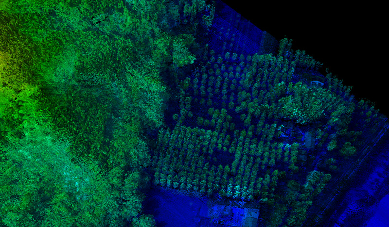
The CW-15, paired with the JoLiDAR-120, transforms forest mapping by collecting 144 points per square meter, creating detailed 3D maps capturing the smallest branches and leaves. With 32 returns, it classifies trees, shrubs, groundcover, and individual plant species. This wealth of information empowers users to develop precise vegetation management plans, allowing for strategic identification of areas requiring clearing, trimming, or herbicide application.
Read More


Let’s be honest: the drone world loves its acronyms. UAV, UAS, drone, RPAS, UCAV, FPV–it’s an alphabet soup. And most people use them like they’re the same thing.
They’re not.
And here’s why that matt
An airborne cargo drone is exactly what it sounds like: an unmanned aircraft built to carry stuff. Not tiny packages for a suburban backyard – real cargo. From medical supplies to industrial parts.
An

JOUAV Product News and Use Cases
Fixed-Wing VTOL Drones Insights and Industry Trends
Invitations to online demo events