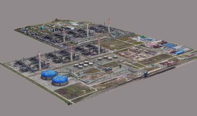
Environmental Protection Sand Table
Utilize advanced technologies such as GIS technology, remote sensing technology, oblique photography automatic modeling technology, computer technology, electronic sand table technology, etc. Realize the visual query, display, and browse of various production, operation, emission, and status in the area. Fully demonstrate the achievements of environmental protection information and provide a carrier for in-depth information applications.
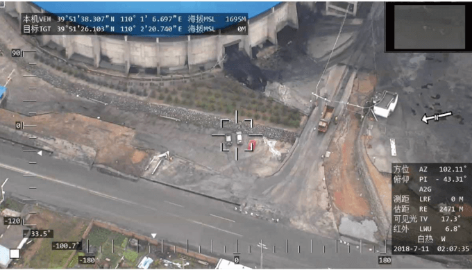
Real-time Inspection of Environmental Violations
Using a JOUAV VTOL drone to carry high-definition aerial photography equipment and related water resources monitoring equipment can inspect various water areas to monitor sewage discharge. For example, in terms of wastewater discharge treatment and monitoring, the lightweight dual-light pod carried by the UAV platform can be used to monitor wastewater and heat pollution at night by the infrared lens. It is also possible to use a 30x zoom visible light camera to monitor sewage discharge through changes in water color. The UAV transmits video data in real-time to operators and supervisors. The UAV inspection system cooperates with ground maintenance personnel, and when problems are found, they can be transmitted to the nearby inspectors in time to guide the inspectors to be in place in time, discover pollution facilities or suspicious discharge points, and continue to track and store evidence. At the same time, the collected data is kept at any time to prepare for further analysis by experts.
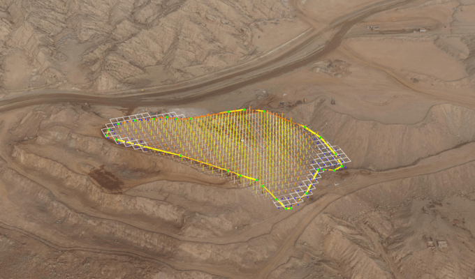
Water and Soil Conservation Monitoring Data Extraction
UAV low-altitude remote sensing information extraction can obtain image features and spatial features of images through visual interpretation and computer information extraction methods. The data extraction of low-altitude remote sensing soil and water conservation monitoring data by drones includes:
1) Direct observation of data, which can directly observe the prevention and control of soil erosion from the DOM;
2) Directly extract data, using Global-Mapper 15, using software measurement tools and polygon creation function, you can extract the length and area data required for monitoring;
3) Indirect calculation of data, through direct extraction of data combined with drone surveying and measurement, the volume of data required for monitoring can be indirectly calculated. The extraction of these data provides a data basis for the comprehensive evaluation of soil erosion and soil conservation and provides a data basis for the quarterly report form and monitoring summary report of soil and water conservation monitoring.
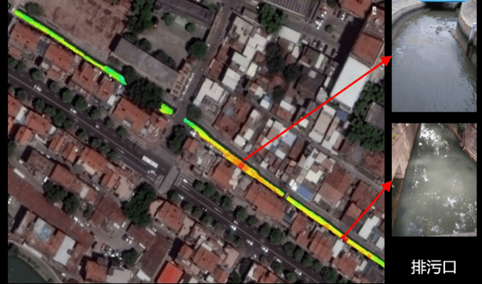
Sewage Outlet Investigation
Because the inland water environment is complex, the water area is relatively small, the pollution types are diverse, and the data accuracy requirements are high, drone applications to monitor the inland water environment has unique advantages. Short-period monitoring of the cleanliness of water bodies, and real-time acquisition of corresponding monitoring indicators for different types of pollution sources, mainly including water temperature, red tide, water depth, transparency, algae blooms, etc. The main task and goal of the sewage outlet survey are to fully grasp the location of the sewage outlet, the types of sewage, and the concentration of main pollutants, and scientifically evaluate the monitoring results to provide a scientific basis for the management of the sewage outlet.
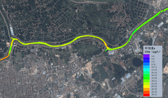
Water Quality Parameter Inversion
Water pollution contains a lot of content. There are more than 40 monitoring data in routine testing. Remote sensing can be used to monitor many components of water quality, such as suspended solids concentration, chlorophyll a, total phosphorus, total nitrogen, ammonia nitrogen, and chemical oxygen demand Among them, chlorophyll in the problem of eutrophication is the most accurate indicator of remote sensing monitoring methods. The remote sensing image data obtained by the UAV equipped with imaging spectroscopy equipment, combined with the measured data of the water quality at a fixed point in the water area, construct a monitoring index inversion model to achieve a rapid and comprehensive prediction of the corresponding index concentration of the entire water area.
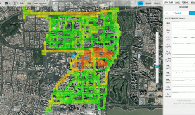
Real-time Monitoring of Atmospheric Component Concentration
Nowadays, many environmental protection agencies have adopted remote sensing technology as the main means of regional monitoring. Drone surveillance has the advantages of 3D monitoring, fast response speed, wide monitoring range, and low terrain interference. It is one of the important development directions for the identification of pollution sources and concentration monitoring of atmospheric emergencies in the future. At the same time, multi-UAV collaborative monitoring of atmospheric pollutants will be carried out for environmental map modeling, task allocation, and path planning, mainly for the monitoring and research of indicators such as ozone, particle concentration, temperature, humidity, NO2, and SO2. The system can be applied to air quality monitoring, dust monitoring, environmental emergency, environmental protection, fire rescue, pollution source traceability, chemical park inspection, gas pipeline inspection, and other fields.
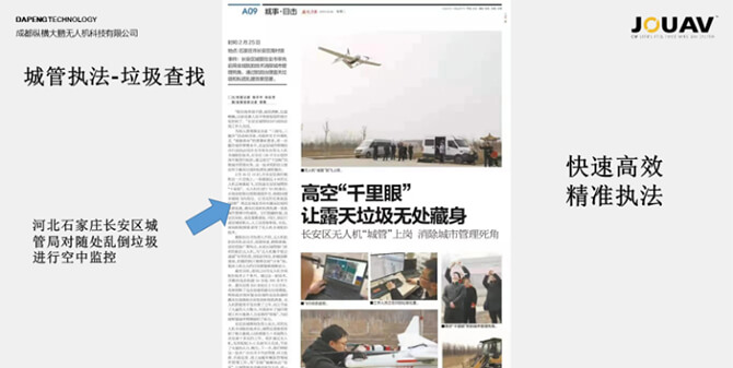
White Garbage Pollution Treatment in Shijiazhuang, Hebei
In February 2019, Chang'an District, Shijiazhuang, Hebei Province, used UAV to obtain orthophotos of the entire region and carried out illegal disposal of garbage dumps around the city. By acquiring orthophotos, illegal garbage dumps around the suburbs can be found, and environmental law enforcement vehicles can be arranged for proper disposal.
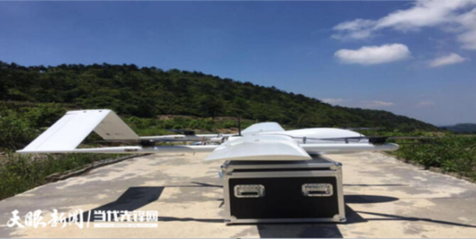
Construction of Remote Sensing Monitoring Platform for Ecological Conditions in Guizhou Province
From July 15 to August 3, 2019, the Guizhou Provincial Environmental Engineering Assessment Center used a medium-to-large gasoline-electric hybrid VTOL drone, equipped with precision digital aerial cameras, to control the Chishui River and Wujiang River Basins. Along the bank, the inspection and flight operations of the sewage outlets into the river will be carried out, and the basic data will be provided for the next step of manual inspection work. The inspection and remediation work has been successfully completed.
Satellite Environmental Application Center, Ministry of Ecology and Environment, Air Pollution Prevention and Control
Use satellites and UAVs to participate in the assessment of the completion of the key tasks of air pollution prevention and control, and participate in the adjustment and optimization of industrial structure, clean production, coal management, industrial air pollution control, urban dust pollution control, building energy conservation and heating metering, and atmospheric Assessment of pollution prevention and control capital investment and atmospheric environment management.
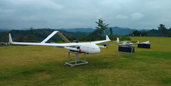

More information about JOUAV and our drones
Provide the suitable solution for your needs
Help for your project promotion
Get a product quote