Overview
GCS-303 Ground Control Station is capable of controlling the flight operations and gimbal cameras at the same time. With a terminal control and transmission Base (GCS-1000), this ground station is easy to carry and suitable for any harsh environment.
grid-image
Benefits and Features
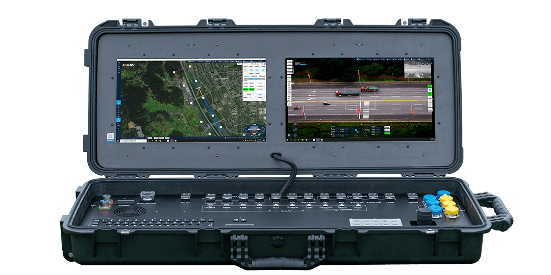
GCS-303 ground control station has a professional graphics card, enabling the operator to plan, execute and track the UAV in real-time. In addition to this, it is equipped with two batteries and 1T of memory, giving it a longer endurance and more memory storage than other ground control stations.
product-detail
Portable Ground Control Station
Well suited for typical flight operations in field environments
product-detail
Screen Brightness up to 480cd/m2
Allow the system to work under extreme sunlight conditions
product-detail
Two Different Screen Monitors
One displays information about the mission plan while the other screen shows video streams
product-detail
Integrated 3 Ethernet Ports
3 x 100M RJ45 Ethernet ports for fast network communication
product-detail
Equipped with professional GPU
Enable High-performance Processing Capacity
product-detail
2 Power Supply Batteries Included
Provide seamless battery switching for long endurance
product-detail
With a Large Onboard Memory of 1T
Store up to 200 hours of high-resolution video and 100 mission plans
product-detail
Include a Joystick for Payloads
Enable 3600 controls of the gimbal including pan, tilt, rotate and zoom
Technical Specification
Computer System
CPU
Intel 8th I7
Memory
16GB
Stoarge
SSD 1TB
GPU
NVIDIA P1000
Display System
Dimension
22.7 Inch
Brightness
Max. 480cd/m2
Resolution
1920×1080
Connection Port
Power Port
Y50DX-2 pin *2
USB Port
USB-TYPEA*3
Lan Port
RJ45*3
VGA
HDMI-TYPEA*1
LiPo Battery Supply
Input
24V
Voltage
6S3P/22.2V
Capacity
42Ah
Other
Working Temperature
0℃ -40℃
Dimension Size
970.5mm×413.5mm×158.5mm(L×W×H)
Weight
17.5kg(without package)
Endurance
4.5h (single LiPo Battery )
Map Display
Google, Bing, Google Satellite, Google Terrain, SRTM, 3D DEM, Geo-rectified Orthomap
Commanding Capability
UAV, EO & IR payload
Software
JOUAV Eagle Map
* All performance data in the foregoing pages are theoretical values obtained by JOUAV® internal laboratories through tests carried out under particular conditions. For more information on the specific testing conditions, refer to the aforementioned product details. Actual performance may vary owing to differences in individual product configuration, software versions, application conditions, and environmental factors. All data is subject to actual usage.