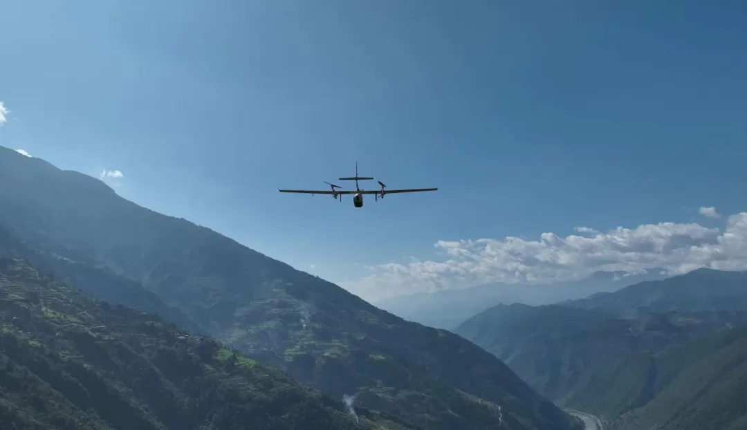
Class E airspace is everywhere, but it’s rarely obvious. It can start at the surface, at 700 feet, or at 1,200 feet—and if you’re a drone pilot, that difference changes everything.

So how do you read it on a chart, know the rules, and fly legally within it?

This guide breaks down what Class E is, where it begins and ends, and why it’s essential knowledge for safe flight, both manned and unmanned.

What is Class E Airspace?

What is Class E Airspace?

Class E is the most common and widespread type of controlled airspace. Its primary job is to provide a seamless, controlled environment for aircraft flying on instrument flight rules (IFR), especially during transitions between busy terminal areas and the high-altitude en-route structure.

Think of it as the "default" controlled airspace. If you picture a map, the vast majority of the sky not explicitly designated as Class A, B, C, D, or G is, in fact, Class E. This has earned it informal nicknames like "Class Everywhere" among pilots. It acts as the essential bridge between the highly structured airspace around major airports and the truly uncontrolled freedom of Class G.

what is class E airspace

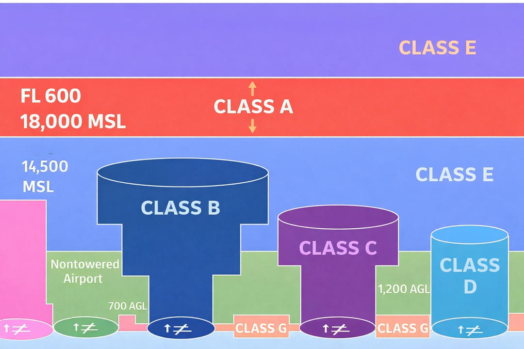
What makes Class E unique, and sometimes confusing, is its accessibility. Unlike Classes B, C, and D, a pilot in a small aircraft generally does not need to talk to Air Traffic Control (ATC) or obtain explicit permission to enter Class E airspace under visual flight rules (VFR). It provides ATC services to IFR aircraft automatically, while being permissive to VFR traffic. This creates a hybrid environment: controlled for separation and safety of instrument traffic, but open for visual flight.

However, "less restrictive" does not mean "rule-free." Class E maintains important regulations, particularly regarding weather visibility, cloud clearances, and, at higher altitudes, equipment. For instance, specific gear like a transponder and ADS-B Out becomes mandatory in Class E at and above 10,000 feet MSL.

JOUAV CW-30E - 100/200km Range Drone for Surveillance

How to Identify Class E Airspace on a Sectional Chart?

Identifying Class E on a sectional chart is honestly one of the most confusing parts of ground school. Unlike Class B or C, which are always drawn as a bold, clearly defined ring, Class E is shown through a combination of colors, shading, and subtle boundary cues.

1. The Dashed Magenta Line

This is your highest-priority signal. When you see a dashed magenta line (--- --- ---) forming a circle or shape around an airport, it’s telling you one critical thing: Class E airspace starts at the ground here. It resembles a loosely stitched, pinkish border around the airport's symbol.

You are looking at a Class E Surface Area. From the grass on the runway up to 18,000 feet, this is controlled airspace. For your drone, this means you must have an FAA authorization (like an LAANC clearance) before you take off inside this line. No exceptions. It’s commonly found at non-towered airports that have instrument approaches.

Dashed magenta line on an aviation sectional chart

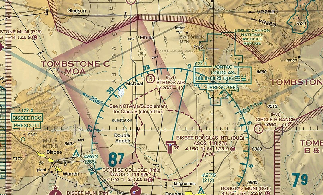
2. The Shaded Magenta Fade

This one is subtler. Look for a wide, fuzzy, faded band of magenta color surrounding an airport. It doesn’t have a hard edge; it looks more like a soft glow or shadow. Imagine someone took a magenta highlighter and gently shaded a wide ring around the airport, letting it fade out.

This marks a Class E shelf starting at 700 feet Above Ground Level (AGL). Inside this shaded band, the airspace from 700 ft and up is controlled. But here’s the key for drone pilots: the airspace from the surface up to 700 ft is Class G (uncontrolled). Since you’re flying below 400 ft, you’re operating in this uncontrolled layer. You do not need a specific Class E airspace authorization here. You just need to follow standard Part 107 rules.

Shaded magenta fade on an aviation sectional chart

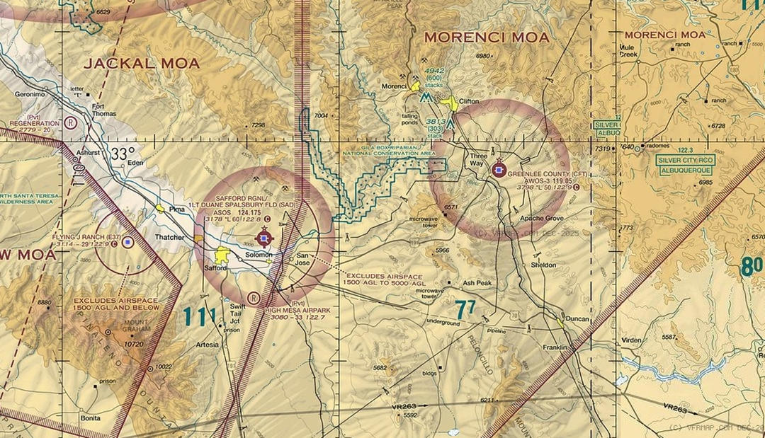
3. The Shaded Blue Vignette

This is the most common, yet least obvious, clue. The entire chart is printed on a light cyan (a soft blue-green) background. This isn't just pretty coloring; it's meaningful. The paper itself seems tinted a very light bluish-green. It’s the canvas on which everything else is printed.

Wherever you see this cyan background and you don't see one of the magenta markings described above, you are in an area where Class E airspace starts at 1,200 feet AGL. The sky from 1,200 ft up is controlled. Everything below that, down to the dirt, is Class G. Your drone at 400 ft is safely in uncontrolled territory. No authorization is needed based on the Class E airspace.

Shaded Blue Vignette on an aviation sectional chart

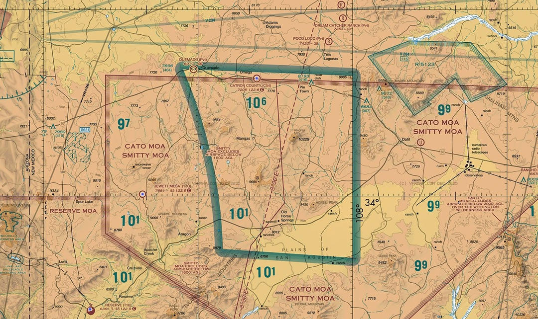
4. Blue Zipper Lines

In areas of complex terrain or special use airspace, the Class E floor isn't a nice round number. Here, you’ll see a zig-zagging or scalloped blue line that looks like a zipper or a series of bumps. Next to this line, a number like 8000 is printed.

This line marks a sudden change in the Class E floor. The number (e.g., 8000) indicates the floor on the controlled side of the line is 8,000 feet Mean Sea Level (MSL). The floor on the other side is different (usually higher).

For all practical drone purposes, this is irrelevant, as 8,000 ft MSL is far above your operational ceiling. It’s included here so you won’t be puzzled when you see it.
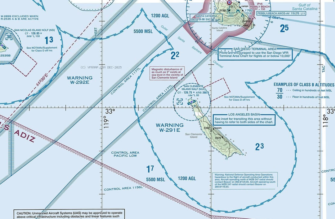
Blue zipper lines on an aviation sectional chart

5. The Blue Lines

The light blue, double-lined corridors labeled with a "V" and a number (e.g., V12) are Federal Victor Airways. These airways are tubes of Class E airspace. They are 8 nautical miles wide (4 nm on either side of the centerline) and extend from 1,200 ft AGL up to, but not including, 18,000 ft MSL.

You are extremely unlikely to conflict with this airspace laterally, as it’s designed for cruising aircraft. However, it reinforces that the sky above 1,200 ft is a structured network of controlled routes.

Federal victor airways

What Are the Dimensions of Class E Airspace?

What Are the Dimensions of Class E Airspace?

Knowing where Class E airspace ends completes the picture and is essential for comprehensive mission planning, especially for long-range BVLOS operations.

Vertical Limits:

  • Lower Limit: As defined above—the surface, 700 ft AGL, or 1,200 ft AGL.
  • Upper Limit: In the continental United States, Class E airspace typically extends upward to, but does not include, 18,000 feet Mean Sea Level (MSL). At this point, it transitions to Class A airspace.
  • The High-Altitude Exception: Class E airspace resumes above 60,000 feet MSL (Flight Level 600), extending to the edge of controlled airspace. While far beyond the realm of drone operations, this fact underscores its role as the foundational "fill-in" category for the entire National Airspace System.

Lateral Limits (Horizontal Spread):

Class E is not standardized in shape. Its lateral boundaries are defined by the depictions on the chart.

  • For Surface Areas and 700-foot shelves, the lateral limit is the specific magenta line drawn around the airport.
  • For the default 1,200-foot layer, it has no defined lateral boundary; it exists everywhere unless specifically replaced by another class of airspace (like a Class B, C, or D area). Effectively, it ends where another class begins.
Weather Minimums for Operating in Class E Airspace

Weather Minimums for Operating in Class E Airspace

The weather requirements in Class E change depending on your altitude. The "magic number" to remember is 10,000 feet MSL.

Below 10,000 Feet MSL: The "3-152" Rule

For most general aviation and almost all drone flights, this is the rule you’ll live by. You can remember it using the mnemonic "Cessna 152" (a common training plane) prefixed with a 3.

  • 3 Statute Miles Visibility: You must be able to see at least 3 miles from your control station.
  • 500 Feet Below: You must stay at least 500 feet below the base of any clouds.
  • 1,000 Feet Above: If you are flying above a cloud layer (not common for drones, but possible for manned flight), you must stay 1,000 feet above them.
  • 2,000 Feet Horizontal: You must stay at least 2,000 feet (about 0.38 miles) away from clouds horizontally.

At or Above 10,000 Feet MSL: The "5-111" Rule

Once you go above 10,000 feet, the rules get significantly tighter. Why? Because planes fly much faster at higher altitudes (over 250 knots), and they need more "buffer" time to see you.

  • 5 Statute Miles Visibility: Visibility requirements jump up to give pilots more reaction time.
  • 1,000 Feet Below: A larger vertical buffer from clouds.
  • 1,000 Feet Above: Consistent vertical spacing.
  • 1 Statute Mile Horizontal: You need a massive horizontal gap from clouds so you don't "pop out" in front of a fast-moving jet.

Why Does This Matter for Drones?

You might be thinking: "My drone is capped at 400 feet AGL. Why do I care about rules for 10,000 feet?"

There are two critical reasons:

1.The "500-Foot Below" Trap: If the cloud ceiling is at 700 feet AGL, and the law says you must stay 500 feet below the clouds, your maximum legal flight altitude is now 200 feet AGL—not 400 feet. The weather has effectively "shrunk" your available airspace.

2.High-Altitude Operations: If you are using a drone for a mission in high-altitude regions (like the Rockies or the Andes), you might easily be at a ground elevation of 9,500 feet MSL. If you fly 600 feet up to inspect a peak, you have crossed that 10,000-foot MSL threshold and must now follow the much stricter "5-111" rule.

Why Does This Matter for Drones?

Why Does This Matter for Drones?

You might be thinking: "My drone is capped at 400 feet AGL. Why do I care about rules for 10,000 feet?"

There are two critical reasons:

1.The "500-Foot Below" Trap: If the cloud ceiling is at 700 feet AGL, and the law says you must stay 500 feet below the clouds, your maximum legal flight altitude is now 200 feet AGL—not 400 feet. The weather has effectively "shrunk" your available airspace.

2.High-Altitude Operations: If you are using a drone for a mission in high-altitude regions (like the Rockies or the Andes), you might easily be at a ground elevation of 9,500 feet MSL. If you fly 600 feet up to inspect a peak, you have crossed that 10,000-foot MSL threshold and must now follow the much stricter "5-111" rule.

CW-15 flew in mountains

Tips for Operating in Class E Airspace

Tips for Operating in Class E Airspace

Efficiency and safety in Class E require more than just knowing the rules; they require a high level of situational awareness.

1. Master the "See and Avoid" (and Hear) Principle

In Class E, there is often no air traffic controller (ATC) telling pilots where you are. The burden of collision avoidance sits squarely on your shoulders.

  • Listen to the Radio: Even though drone pilots aren't required to have an aviation radio, we highly recommend using a handheld VHF airband transceiver. Tune into the local CTAF (Common Traffic Advisory Frequency) or UNICOM of nearby airports. Hearing a pilot say, "Five miles out on the 45 for runway 19," gives you minutes of lead time to descend or land before they ever see your drone.
  • Scanning Technique: Don't just stare at your controller. Use the "block scanning" method—look at a section of the sky for 2–3 seconds, then move to the next.

2. The "Buffer" Strategy for Weather

We talked about the 3-152 rule (3 miles visibility, 500' below, 1,000' above, 2,000' horizontal from clouds). In the real world, you should treat these as minimums, not targets.

  • The Cloud "Pop-Out" Risk: Small planes can emerge from clouds at 120+ knots. If you are exactly 2,000 feet horizontally from a cloud, a fast-moving plane will cover that distance in about 10 seconds.
  • Pro-Tip: If the sky is "patchy" (scattered clouds), keep your drone well below the 400ft ceiling to give yourself more vertical separation from aircraft descending through those gaps.

3. Precision Planning for Surface Areas (E2)

If you are operating in a Class E Surface Area (dashed magenta), your pre-flight routine needs to be airtight.

  • Check the Grid: Use a LAANC provider (like AirControl or UAS Sidekick) to check the UAS Facility Maps. Some Class E airports have "0-foot" zones near the runway where you cannot fly without a manual waiver.
  • The "Shadowing" Trick: If you are doing a bridge or tower inspection in a Class E surface area, try to stay close to the structure. Manned pilots are trained to stay away from obstacles, so "shadowing" the structure adds an extra layer of physical safety.

4. High-Altitude Density Considerations

Many drone missions happen in remote, high-elevation areas where the Class E floor might be 1,200ft AGL, but the MSL (Mean Sea Level) altitude is 8,000ft or higher.

  • Performance Check: Remember that as you go higher in Class E, the air gets thinner. This affects your drone's lift and battery efficiency. Always calculate your density altitude before a high-elevation Class E mission to ensure your VTOL can perform its transition and landing maneuvers safely.

5. Managing Long-Range (BVLOS) in Class E

If you are performing Beyond Visual Line of Sight (BVLOS) operations (with the necessary FAA waiver), Class E is particularly challenging.

  • DAA (Detect and Avoid): Use technical aids like ADS-B In. While your drone must have Remote ID, having an ADS-B In receiver allows you to see manned aircraft on your ground station map long before they are audible.
  • Note: In 2026, many industrial drones are equipped with onboard AI vision systems to help spot "non-cooperative" traffic (planes without transponders).
Class E vs. Class G Airspace

Class E vs. Class G Airspace

At the highest level, the difference is categorical: Class E is "Controlled" airspace, while Class G is "Uncontrolled." But in practice, it's more nuanced. Think of them not as separate zones, but as vertical layers.

Class G (Uncontrolled Airspace)

This is the aviation equivalent of an open field or a country road. Air Traffic Control (ATC) provides no separation services. It is the pilot's responsibility—or the drone pilot's responsibility—to see, avoid, and navigate safely.

Typically, it's the airspace from the surface upward until it meets the floor of overlying Class E (at 700 ft or 1,200 ft AGL). It can also exist in pockets from the surface up to 14,500 ft MSL in rare, remote mountainous areas.

Class E (Controlled Airspace)

This is the "managed" airspace, even if quietly so. Its primary purpose is to provide a controlled environment for Instrument Flight Rules (IFR) traffic. ATC separates all IFR aircraft here. For Visual Flight Rules (VFR) pilots in manned aircraft, it's more structured than Class G but doesn't require talking to ATC.

Everywhere else. It exists from a designated floor (surface, 700 ft, 1,200 ft) upward to 17,999 ft MSL, forming a nationwide network.

Class E vs. Class G at a Glance

Factor

Class G (Golf)

Class E (Echo)

Status

Uncontrolled

Controlled

Default Floor

Surface

1,200' AGL (usually)

Day Visibility

1 SM

3 SM

Cloud Rules

Clear of Clouds

500' below, 1000' above, 2000' horizontal

ATC Services

None

Separation for IFR traffic

Drone Permit?

No

Only in Surface Areas (E2)

The Critical Drone-Specific Implications

This is where theory meets the tarmac. For a drone pilot limited to 400 feet AGL, the question isn't just "E or G?" It's: "At my location, what is the floor of Class E?"

1. If the Class E floor is 1,200 ft AGL: You are operating entirely in Class G airspace. No airspace authorization is needed. This is common in rural areas.

2. If the Class E floor is 700 ft AGL: You are operating in Class G airspace (from 0-700 ft). No airspace authorization is needed for the Class E above you. This is common around many non-towered airports.

3. If the Class E floor is the SURFACE (Class E2/E4): You are operating in controlled airspace the moment you take off. FAA authorization is mandatory. This is the key operational trigger.

FAQ

FAQ

How to Tell If Class E Starts at 700 or 1200?

You determine this by reading a VFR Sectional Chart. The chart uses specific visual codes to indicate the floor of Class E airspace.

  • If it starts at 700 feet AGL: You will see a wide, faded (or "fuzzy") magenta line or band surrounding an airport. This is often called a "magenta vignette." The airspace inside this shaded band has a Class E floor of 700 ft AGL. The airspace below that, down to the surface, is Class G.
  • If it starts at 1,200 feet AGL: This is the default and most common configuration. It is depicted by the light cyan (blue-green) background that covers most of the chart. If you are in an area with this cyan background and there is no faded magenta band or dashed magenta line nearby, then Class E begins at 1,200 ft AGL. The airspace below is Class G.

Since drones operate below 400 ft AGL, if you are outside of any dashed or faded magenta markings, you are virtually always in Class G airspace. Your primary concern is to look for the dashed magenta line that indicates a surface-based Class E area, which requires authorization.

Can You Fly VFR in Class E Airspace?

Yes, absolutely. VFR (Visual Flight Rules) flight is perfectly legal and common in Class E airspace. In fact, it's where a significant portion of general aviation cross-country VFR travel occurs.

  • For Manned Aircraft: Pilots do not need to establish two-way radio communication with ATC or receive a clearance to enter Class E. However, they must adhere to the VFR weather minimums (3 statute miles visibility, 500 ft below/1000 ft above/2000 ft horizontal from clouds below 10,000 ft MSL). They may contact ATC for optional flight following (traffic advisories).
  • For Drone Aircraft (Part 107): The term "VFR" is not directly applicable in the same way. Drones operate under Part 107 rules, which have their own weather minimums (3 statute miles visibility and a mandate to never fly in clouds). A drone pilot with authorization can operate in surface-based Class E, but they are not "flying VFR" in the traditional sense—they are conducting a controlled operation under a specific set of unmanned aircraft regulations.

Can I Fly over Class E Airspace?

This question has two interpretations, both with a "yes, but" answer.

Interpretation 1: "Can my drone fly above the Class E airspace layer?"

The Short Answer: This is largely irrelevant for drones. Class E airspace typically extends up to 17,999 ft MSL. Drones are limited to 400 ft Above Ground Level (AGL), with a waiver. Therefore, your drone will always be operating well below the vast majority of Class E airspace. You are almost always flying in the Class G airspace beneath the Class E floor (700 or 1200 ft AGL), not "over" it.

Interpretation 2: "Can I fly my drone in the sky above an area marked as Class E on the chart?"

The Short Answer: Yes, but you must confirm where the Class E starts.

  • If the Class E starts at the surface (dashed magenta line), you are flying IN it, not over it, and you need authorization.
  • If the Class E starts at 700 ft or 1200 ft AGL, and you fly your drone below 400 ft, you are flying in the Class G airspace that is underneath it. You are legally "over" the ground but operationally "under" the Class E layer. No authorization is needed for the airspace in this scenario.

For Advanced Operations: If you have a waiver to fly a drone above 400 ft AGL (e.g., for inspecting a tall structure), and that altitude places you above the 700 ft AGL floor of Class E, then you would be operating within Class E airspace and would need the appropriate authorization for that altitude block. This is a complex scenario requiring careful coordination.

Share :
Read More
thumbnail
Drones are now more than just toys. At first, they were a hobby for a few people, but now they are a big industry. They change how we film, map, check things, and even farm. In 2026, drones are fast,
thumbnail
If you’ve ever watched a drone race or a breathtaking chase scene filmed from the sky, you’ve probably already seen an FPV drone in action. FPV stands for First-Person View, and it’s exactly what it s
thumbnail
If you’ve ever planned a hike and opened a topographic map covered with contour lines and symbols, you know it can look overwhelming at first. Learning how to read a topographic map is an essential ou