Millions lost, projects delayed: Construction site theft is a costly reality.
According to the National Equipment Register,a staggering $300 million to $1 billion lost annually in stolen construction
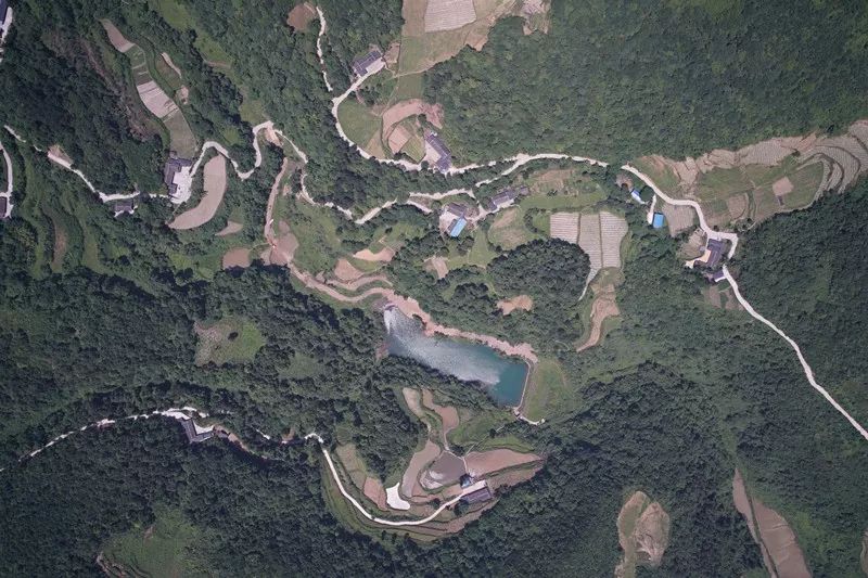
With the development of surveying and mapping, new technologies are gradually replacing traditional surveying and mapping methods. At the same time, it has brought significant changes to surveying and mapping workers. The most notable is the drone surveying and mapping technology that has emerged in recent years. Aerial surveying and mapping have the characteristics of flexibility, high efficiency, rapidness, precision and accuracy, low operating cost, wide application range, short production cycle, etc. However, in the surveying and mapping process of UAVs, there will be many external factors that significantly impact the accuracy of the data. Therefore, while using new technology, we must also avoid the influence of these external factors on the results.
Factors affecting the accuracy of aerial drone surveys
Flight Control Technology
The UAV is small in size and light in weight, and it is greatly affected by airflow, wind, and wind direction during aerial photography. The flight of the UAV is unstable, and the attitude angles such as the yaw angle, pitch angle, and roll angle are relatively large during flight. In addition, due to the low flying altitude of the UAV and the relatively fast-moving speed of objects on the ground, the structure of the ground objects on the imaging surface will be displaced during the exposure process. The appearance of the displacement of the system will blur the image and affect the imaging quality.
Camera quality
The camera objective lens has significant chromatic aberration and distortion.
The camera objective lens has different refractive indexes for the light of different wavelengths, so it forms a focal point on the focal plane, which produces lateral and longitudinal chromatic aberration, making the image blurred and unclear. A camera objective lens is a lens group that uses aspherical grinding technology, and specific residuals are generated during processing, installation, and debugging. Poor distortion makes it impossible to maintain distinct similarities between the subject and the image, resulting in geometric distortion.
CCD chip size and resolution
The resolution is the resolution capability of the CCD chip of the index code camera to the object. The number of pixels is a crucial factor in measuring the resolution of a digital camera. In the same area, the more pixels and the smaller the unit pixels, the higher the image definition, the better the detail performance, and the more realistic color reproduction. Otherwise, the image quality will be worse.
Digital noise
Each roll of the traditional film corresponds to a sensitivity value, and the same digital camera has many different "equivalent sensitivity" values. When shooting with high sensitivity, the sensor signal is amplified, and the interference current is also amplified, causing more noise.
The noise of the digital camera is the performance of its components, the noise reduction technology used in the circuit design, the use of higher sensitivity when shooting, underexposure, long exposure, and other factors. Digital noise causes more noise to the image, which degrades the image quality.
Photo overlap degree, base height ratio
Small digital cameras are mostly CCDs with rectangular fronts, not traditional squares. The greater the degree of photo overlap, the shorter the baseline and the smaller the base-to-height ratio. The base-to-height balance of a compact digital camera is about 0.15, much smaller than the 0.50 of traditional photography. Under the three-dimensional model, the intersection angle of the objects with the same name is slight, which reduces the effect of three-dimensional observation and directly affects elevation measurement accuracy. If under the premise of ensuring three-degree overlap, try to minimize the degree of overlap of the photos or make the long side of the CCD array consistent with the photography route, which can significantly increase the base-to-height ratio and improve the accuracy of elevation measurement.
Image control point target selection
Infield image control point measurement, the selection of the target point mainly depends on the richness of the image texture. Rough image texture, poor intersection angle of arc-shaped features, and linear features will directly affect the accuracy of field point selection. The office processing also has a more significant impact on the transfer of the image control point, which reduces the accuracy of the drawing. Suppose the method of shooting after laying ground points is adopted. In that case, the accuracy of spot selection in the field and the accuracy of turning points in the area can be effectively improved, and it is helpful to improve the quality of the image.
Atmospheric conditions
For photographic imaging, what is more, important than the brightness of the features is the density difference between the images of adjacent features on the photo. If there is no density difference between the features and images, there is no image contrast. The features cannot be distinguished from the images. In addition to the features of the object itself, the factors that determine the image contrast also depend on the difference between the sunlight part and the shadow part. If you choose to shoot in bad weather conditions, the image quality will inevitably deteriorate.
Solutions to improve the accuracy of aerial drone surveys
Improve the accuracy of image control points
The image control point accuracy includes the measurement accuracy and the image target accuracy. The accuracy of using GPS to measure image control points is high, and the error is less than 5cm, which can meet the technical requirements of large-scale mapping. The accuracy of the image control point image target depends on the richness of the image texture. If the image texture is lacking, the office turning point error will reach at least 2 to 3 pixels. Due to the high degree of overlap of images in the UAV route design, if the image control points are first deployed, and then aerial photography is adopted, the accuracy of the internal business turning point can be improved to within 1.5 pixels. The accuracy of image control points can be increased to 0.1 m, and the problem of the uneven layout of photo control points can also be solved.
The quality of the image control point layout plays a very critical role in the last drawing. First of all, at least 5 phase control points are required for each sortie. If the terrain undulates considerably and the number of vegetation is complex, the image control points need to be encrypted. Suppose the image control points are not encrypted, or the distribution is uneven to cover the flight area. In that case, it will cause warpage and result in the adjustment data not meeting the accuracy requirements.
Improve the accuracy of camera distortion parameters
The non-measurement camera carried by the UAV has significant image distortion and varying calibration results. This problem can be solved by improving the accuracy of the camera's distortion parameters. One is to establish a three-dimensional control field to detect the camera distortion parameters before and after UAV aerial photography; the second is to fix the camera lens to reduce the impact of changes in camera distortion parameters on the encryption results.
Improve image clarity
The clarity of drone aerial images is affected by flight speed, shutter speed, and degree of flight turbulence. The flying speed of the drone is controlled at 80km per hour, and the camera shutter speed is 1/120s to reduce image noise.
The exposure time of the camera is closely related to the weather. When the light conditions are not good, the exposure time should be increased as much as possible, and at the same time, the two selected exposure times should be taken separately. Compare the ISO value of the camera. The smaller the ISO value, the better the photo quality, so choose a smaller ISO value.
Flying height control
The flight altitude mainly affects the GSD (the actual size of each pixel) in the flight photo. The change of flight altitude will inevitably affect the size of the photo frame. The closer the aircraft is to the ground and the smaller the GSD value, the higher the accuracy. It was also found that selecting a suitable flight altitude in areas with large ground fluctuations is also essential to improve accuracy.
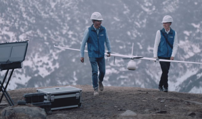
JOUAV is a professional flight control and navigation system of the AP System series developed for professional medium and large drones. It integrates Novatel's high-precision real-time differential GPS module with centimeter-level positioning accuracy. JOUAV independently developed a lightweight gimbal camera payload -MG-120E gimbal camera, equipped with an advanced 30x optical zoom movement and an infrared thermal imaging movement, with a high-performance graphics processor. Using the Nivida Jetson module has ultra-high performance and energy efficiency, this thermal drone can run modern AI workloads, run multiple neural networks in parallel, and process data from various high-definition sensors simultaneously. Improve the accuracy of aerial drone surveys for users.
Read More

Have you ever wondered why Greenland appears larger than South America on a world map? This is a prime example of map distortion, a necessary consequence of transforming our spherical Earth onto a fla
Our modern world relies on hidden resources – the metals in our phones, the minerals in buildings, and the coal that once powered our societies. However, extracting these materials has an environmenta

JOUAV Product News and Use Cases
Fixed-Wing VTOL Drones Insights and Industry Trends
Invitations to online demo events